Spatial database synthesis method in land utilization information multi-scale expression

A comprehensive method and database technology, applied in data processing applications, electronic digital data processing, special data processing applications, etc., can solve problems such as unseen technical methods and inability to meet the comprehensive needs of special information such as land use types and structures. Achieve the effect of realizing dynamic association

Inactive Publication Date: 2009-12-09
WUHAN UNIV
View PDF0 Cites 30 Cited by
  • Summary
  • Abstract
  • Description
  • Claims
  • Application Information

AI Technical Summary

Problems solved by technology

Since the thematic map database not only has the same spatial data as the ordinary map database, but also includes rich semantic information and thematic information, the existing comprehensive technology cannot meet the comprehensive needs of thematic information such as the invariance of land use types and structur

Method used


Image

  • Spatial database synthesis method in land utilization information multi-scale expression
  • Spatial database synthesis method in land utilization information multi-scale expression
  • Spatial database synthesis method in land utilization information multi-scale expression

Examples


Embodiment Construction

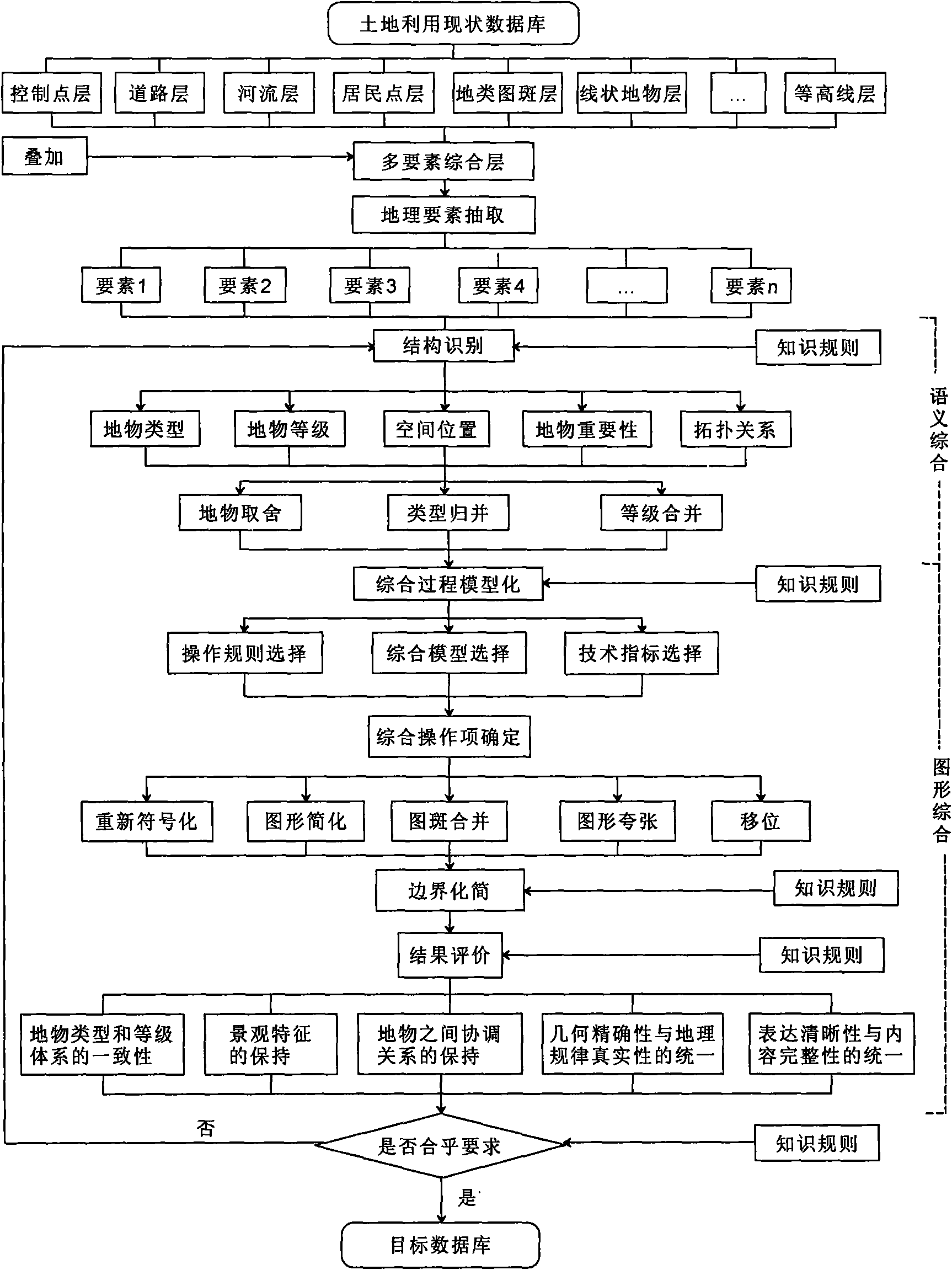
[0020] The method of the present invention will be further described below in conjunction with the accompanying drawings and specific examples.

[0021] The method flow process of database synthesis of the present invention is as figure 1 shown, including the following steps:

[0022] (1) Define the element layers to be synthesized, including the control point layer, road layer, river layer, settlement layer, terrain map patch layer, linear object layer, and contour layer, etc., by superimposing the element layers , to get a multi-element synthesis layer.

[0023] (2) Extract the geographical elements in the multi-element comprehensive layer to determine various elements to be processed.

[0024] (3) Semantic similarity calculation and structural identification of each element to be processed, that is, to determine the feature type, feature level, spatial position, feature and topological relationship importance semantic information of each element;

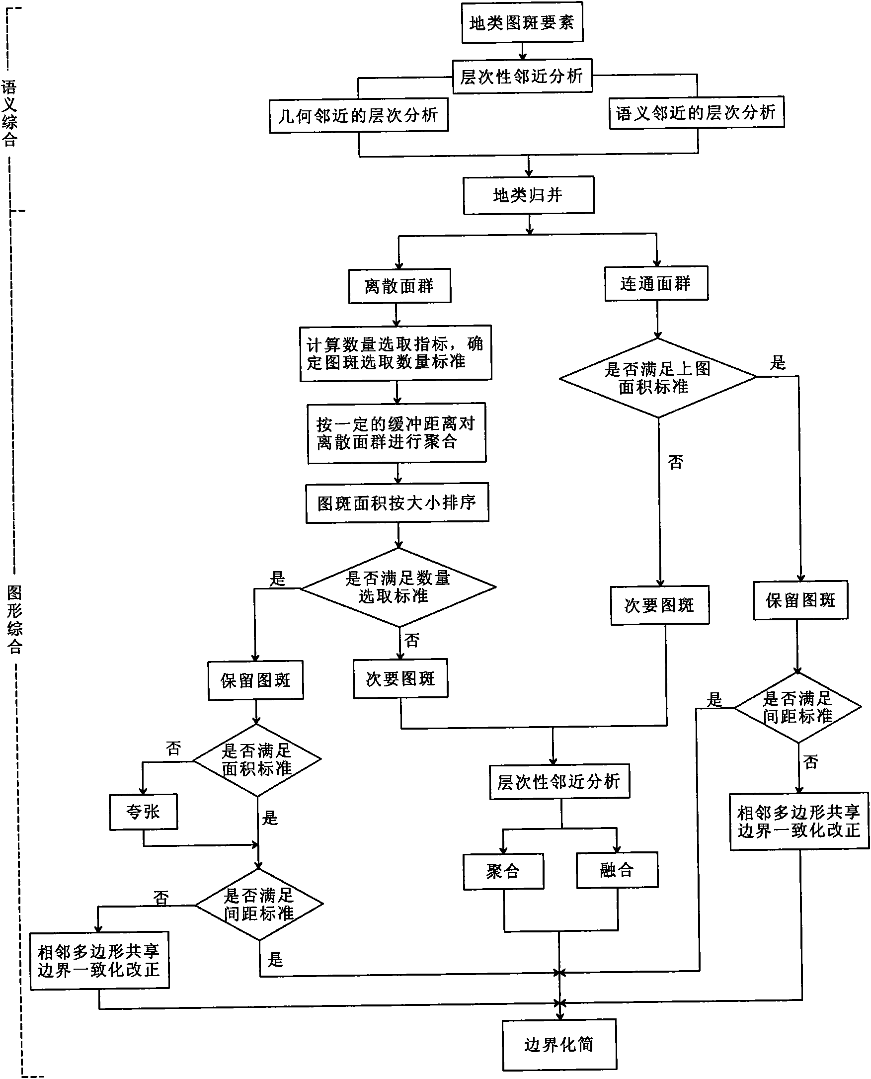
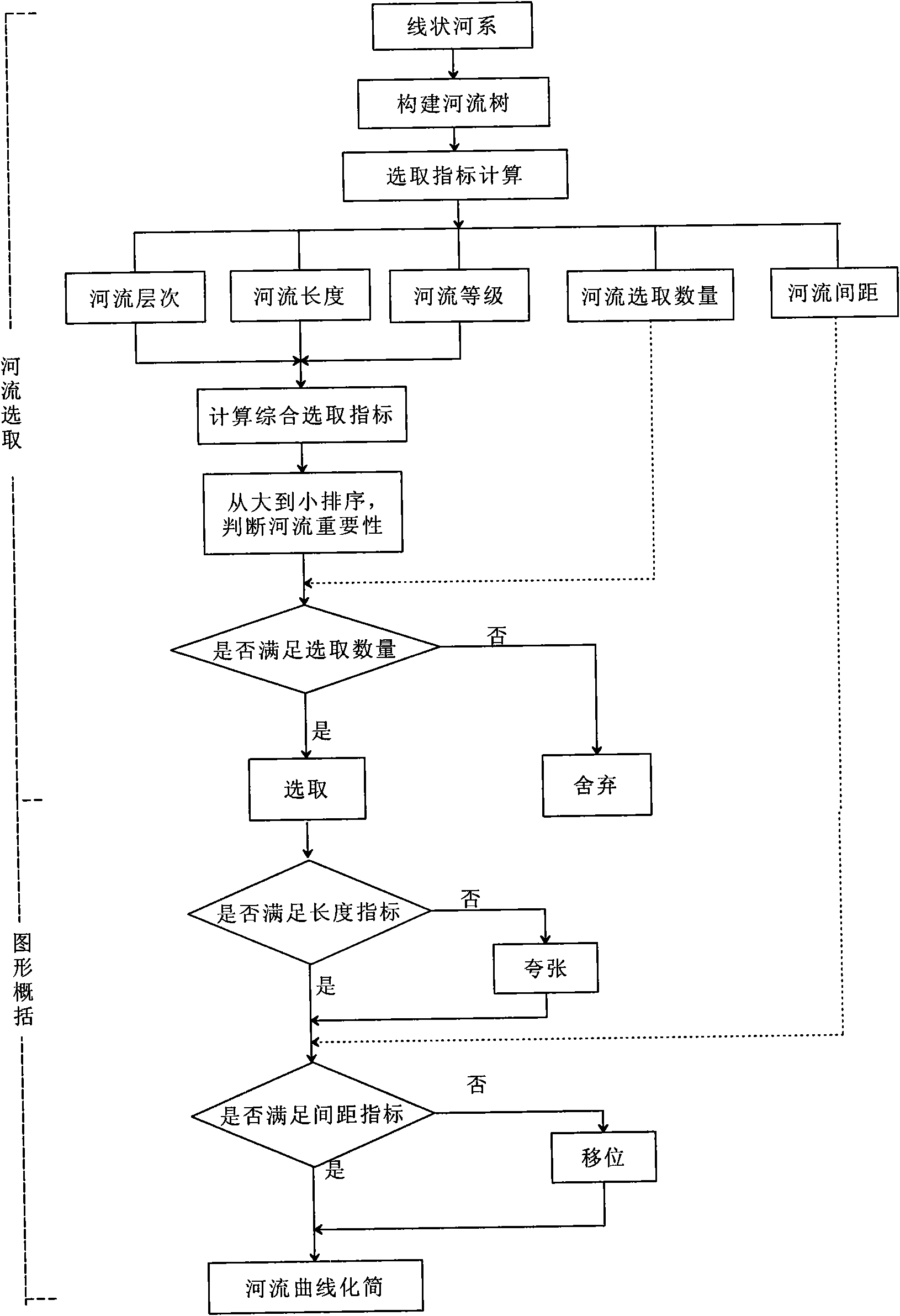
[0025] Computing the s...


PUM


Abstract

The invention discloses a spatial database synthesis method in land utilization information multi-scale expression; a spatial database in the land utilization information multi-scale expression is synthetically divided into two steps: semantics synthesis and graphics synthesis, wherein, the process of the semantics synthesis is synthesis constraint based on a thematic data base, under the control and guidance of knowledge inference, the geographic characteristics of land features in the database is judged, comprising the steps of identifying the spatial relation of land feature types, land feature grades, spatial position and other land features and determining the importance of the land features, therefore, the process is structural identification. The graphics synthesis is the synthesis of point features, line features and surface features under the guidance of cartography theory. The synthesis model based on the database is built, the standardization of database synthesis is realized, and the disadvantages that the traditional cartography synthesis only concerns graphics synthesis and neglects special semantics synthesis are overcome.

Description

technical field [0001] The invention relates to a spatial database synthesis method, in particular to a spatial database synthesis method in the multi-scale expression of land use information, which belongs to the field of geographic information system and its application. technical background [0002] Cartographic synthesis is a method of selecting and summarizing cartographic materials and cartographic objects according to the purpose of map compilation in order to reflect the basic and typical characteristics of cartographic objects and their internal relations. Its essence is to solve the problem of multi-scale expression generated by the change of map content with the scale. Its task is to comprehensively transform the increase or decrease of map content in the process of changing the scale with the requirements of cartography theory. Cartographic generalization technology is widely used in the field of geospatial information science, and it is the core technology to r...

Claims


Application Information

Patent Timeline
IPC IPC(8): G06F17/30G06Q10/00G06Q50/00G06Q50/26
Inventor 刘耀林何建华夏寅
Owner WUHAN UNIV
Why Eureka
Try Eureka