
Method for calibrating spatial coordinate measuring system of electronic theodolite

An electronic theodolite and measurement system technology, which is applied to radio wave measurement systems, measuring devices, instruments, etc., can solve problems such as inaccurate calibration values, difficulty in standard ruler calibration, and inconvenient carrying of standard rulers, and achieve the effect of reducing dependence

Active Publication Date: 2010-02-24
BEIJING AEROSPACE INST FOR METROLOGY & MEASUREMENT TECH
View PDF0 Cites 50 Cited by
  • Summary
  • Abstract
  • Description
  • Claims
  • Application Information

AI Technical Summary

Problems solved by technology

However, since the standard ruler is a physical benchmark, its length should not be too large (generally within 3m), otherwise, not only is it difficult to calibrate the standard ruler, but also when the environmental conditions such as temperature change or the ruler body is deformed, the calibration value will be inaccurate, and the benchmark If the ruler is too long, it will be inconvenient to carry
Therefore, this solution cannot meet the calibration requirements of the electronic theodolite system in the range of tens of meters
[0015] So far, there is no other report on the calibration of electronic theodolite space three-dimensional coordinate measurement at home and abroad

Method used


Image

  • Method for calibrating spatial coordinate measuring system of electronic theodolite
  • Method for calibrating spatial coordinate measuring system of electronic theodolite
  • Method for calibrating spatial coordinate measuring system of electronic theodolite

Examples


Embodiment Construction

[0066] The present invention will be described in detail below in conjunction with the accompanying drawings and embodiments.

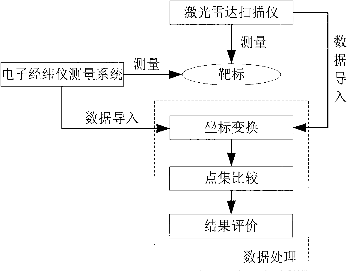
[0067] The basic principle of electronic theodolite system calibration is as follows: Figure 8 As shown, it includes a target 33, an electronic theodolite measuring system 32, a laser radar scanner 34, and an electronic theodolite 32. The basic principle is to use the high-precision laser radar scanner 34 to locate the target, and use this data to judge the electronic theodolite , since the target marks the same point in space for both instruments, the results obtained are highly reliable.

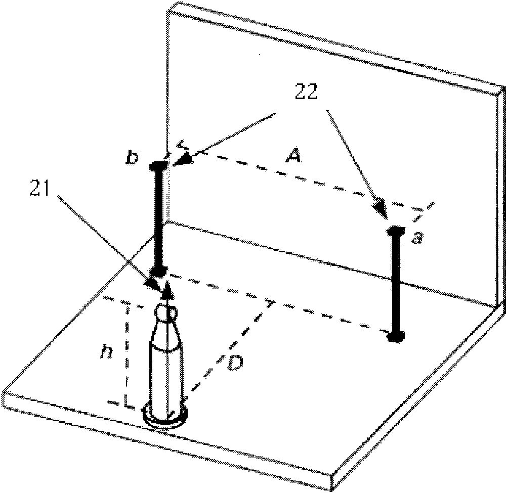
[0068] The measurement process is as image 3 As shown, the specific steps of this calibration method are:

[0069] Step 1. Place the instrument and target;

[0070] Place instruments and targets in the calibration laboratory. The instruments include a laser radar scanner and a set of electronic theodolite system to be calibrated composed of multiple electroni...


PUM


Abstract

The invention discloses a method for calibrating a spatial coordinate measuring system of an electronic theodolite, which aims to meet the need that the measuring system of the electronic theodolite calibrates in the range of tens of meters in any direction at an angle of horizontal 360 DEG and pitching + / -45 DEG. The method comprises the following steps of: placing instruments and targets; 2, using a laser radar scanner to assign a value to the targets to form a standard instrument group; step 3, the calibrated system of the electronic theodolite measures each target to obtain measured values; step 4, converting the measured values of the electronic theodolite to a measurement coordinate system of the laser radar scanner; and step 5, comparing the converted measured values of the electronic theodolite with a standard value thereof, and obtaining the measurement deviation and measurement uncertainty evaluation of the measuring system of the electronic theodolite through software analysis. The method meets the need that the measuring system of the electronic theodolite calibrates in the range of tens of meters in any direction at the angle of horizontal 360 DEG and pitching + / -45 DEG.

Description

technical field [0001] The invention relates to a calibration method of a space three-dimensional coordinate measurement system, in particular to a calibration method of an electronic theodolite measurement system. Background technique [0002] There are many types of large-scale spatial measurement instruments, including theodolite measurement system, laser measurement system, photogrammetry system, etc. The measurement principles of various instruments are different, and different measurement principles lead to different methods for evaluating their measurement accuracy. Therefore, large-scale spatial measurement Calibration of instruments has long had no fully formed standards. [0003] In the national "JJG425-2003 Optical Theodolite Verification Regulations" and "JJG100-2003 Total Station Electronic Speed ​​Meter Verification Regulations", the calibration of the angle measurement of a single theodolite is stipulated, and the space of the measurement system composed of mu...

Claims


Application Information

Patent Timeline
Patent Type & Authority Applications(China)
IPC IPC(8): G01B7/00G01C25/00G01S7/40
Inventor 方芳陈晓晖沈兆欣刘勇殷晴贺燕
Owner BEIJING AEROSPACE INST FOR METROLOGY & MEASUREMENT TECH
Learn More