High spatial resolution remote sensing image crown outline delineation system and method

A high-spatial-resolution, remote-sensing image technology, applied in the field of high-spatial-resolution remote-sensing image canopy outline delineation system, can solve the problems of cumbersome procedures, poor stability of extraction results, etc., and achieve good processing effect

Inactive Publication Date: 2010-03-17
RES INST OF FOREST RESOURCE INFORMATION TECHN CHINESE ACADEMY OF FORESTRY
View PDF0 Cites 24 Cited by
  • Summary
  • Abstract
  • Description
  • Claims
  • Application Information

AI Technical Summary

Problems solved by technology

The object-oriented tree crown extraction method is cumbersome, and the parameters need to be adjusted every time, so the stability of the extraction results is not good

Method used


Image

  • High spatial resolution remote sensing image crown outline delineation system and method
  • High spatial resolution remote sensing image crown outline delineation system and method
  • High spatial resolution remote sensing image crown outline delineation system and method

Examples


Embodiment Construction

[0056] The implementation of the present invention will be described in detail below with reference to the accompanying drawings and embodiments, so as to fully understand how the present invention applies technical means to solve technical problems and achieve the realization process of technical effects and implement them accordingly.

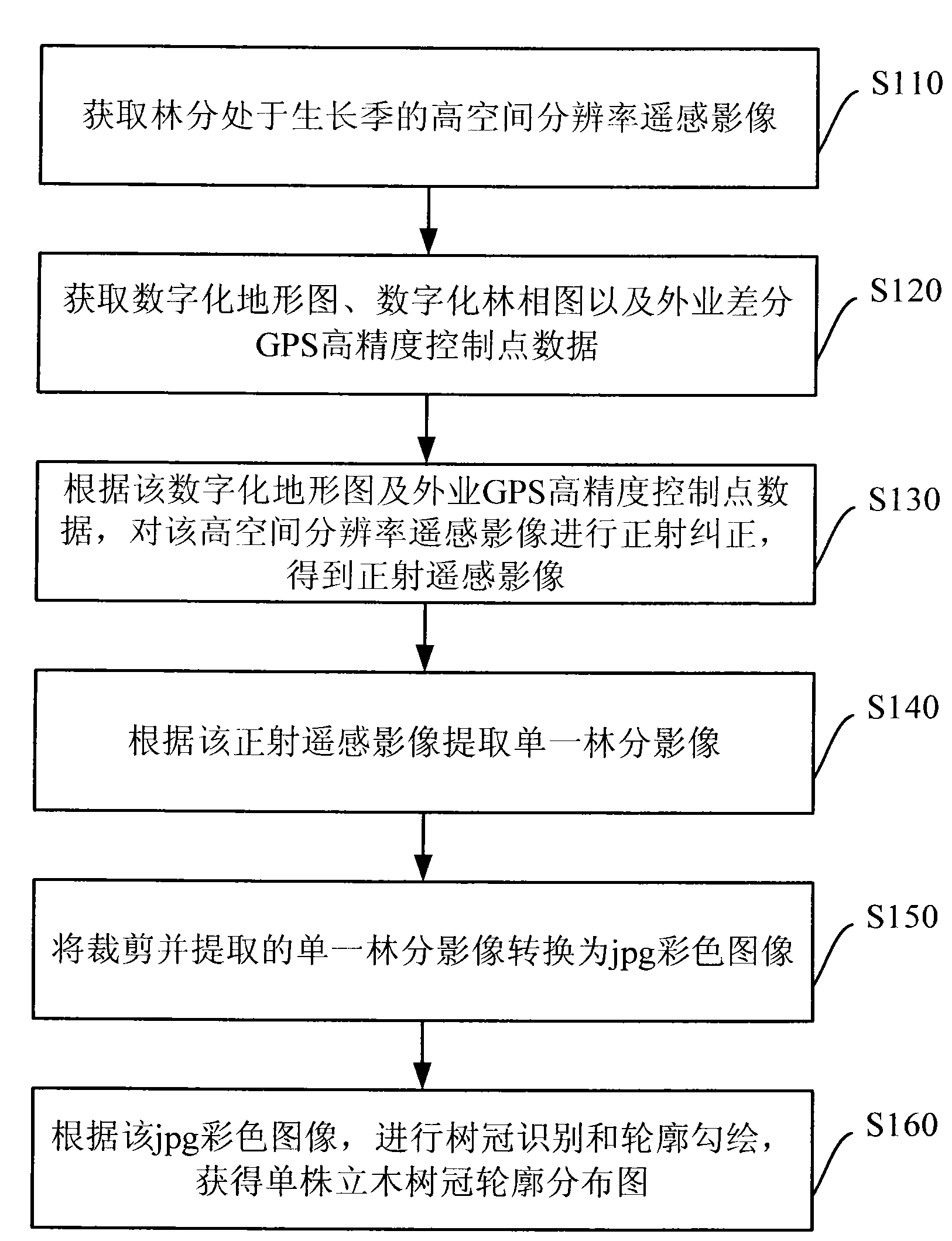
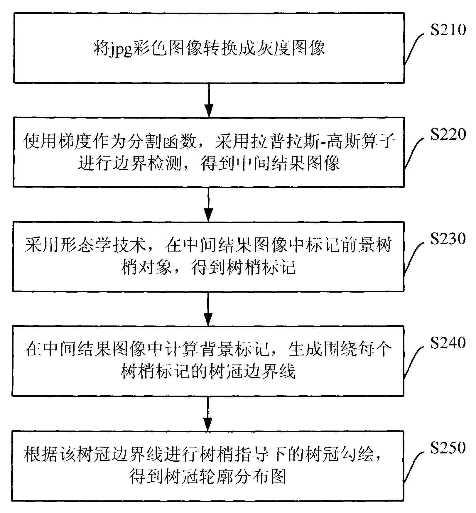
[0057] figure 1 It is a schematic flowchart of an embodiment of the method of the present invention. Such as figure 1 As shown, this method embodiment mainly includes the following steps:

[0058] Step S110: Obtain a high spatial resolution remote sensing image of the forest stand in the growing season;

[0059] Obtain remote sensing images with a spatial resolution greater than 1 meter (m), such images can be aerial charge coupled device image sensors (CCD) digital images, satellite imagery data such as Quickbird panchromatic, IKNOS ) Panchromatic or panchromatic and multi-spectral fusion image;

[0060] In this embodiment, a fusion image of fast b...


PUM


Abstract

The invention discloses a high spatial resolution remote sensing image crown outline delineation system and a method and aims at delineating the crown outline of a high spatial resolution remote sensing image simply and efficiently. The method includes the following steps: acquiring a high spatial resolution remote sensing image with forest stand being in growing season and extracting a single forest stand image; according to the single forest stand image, using gradient as division function and adopting Laplace-Gauss operator to conduct boundary detection on a grayscale image and obtain an intermediate result image; subsequently, adopting morphology technology to mark a foreground treetop object in a front intermediate result image to obtain a treetop tag; calculating a background tag inthe intermediate result image and generating a crown boundary line surrounding each treetop tag; and then conducting crown delineation on the crown boundary line under the guide of treetop to obtain acrown outline distribution chart. Compared with the prior art, the system and the method can be applied to the fields such as forestry investigation, forest resource monitoring, forestry remote sensing and the like.

Description

Technical field [0001] The invention relates to forest resource management technology, and in particular to a system and method for drawing a crown contour of a high spatial resolution remote sensing image. Background technique [0002] At present, the quantitative measurement method of the crown width of a single plant in the actual forest is mostly used to obtain parameters such as the contour of a single tree crown. The method takes the trunk as the center and measures the radius of the trunk in 8 directions or 4 directions respectively, and then uses a circular or elliptical approximation method to obtain the outline of the crown of a single tree, and then estimate the size of the crown of a single tree. This method has a large workload, high cost, low estimation frequency, it is difficult to obtain continuous observation data, and it cannot provide timely and accurate decision support for forest resource management. [0003] Based on high-resolution remote sensing images, tre...

Claims


Application Information

Patent Timeline
Patent Type & Authority Applications(China)
IPC IPC(8): G01S7/48G06T7/60G06K9/00G06T7/62
Inventor 邓广李增元武红敢冯益明庞勇覃先林
Owner RES INST OF FOREST RESOURCE INFORMATION TECHN CHINESE ACADEMY OF FORESTRY
Why Eureka
Try Eureka