
Method and system for estimating vegetation coverage degree in diggings based on close-up photography

A technology of vegetation coverage and close-range photography, which is applied in the field of estimation of vegetation coverage in mining areas based on close-range photogrammetry

Inactive Publication Date: 2010-09-15
CHINA AGRI UNIV
View PDF3 Cites 23 Cited by
  • Summary
  • Abstract
  • Description
  • Claims
  • Application Information

AI Technical Summary

Problems solved by technology

At present, according to the vegetation characteristics of the vegetation restoration area of ​​mining abandoned land (sparse herbaceous vegetation on the ground, the height of which does not exceed 0.8m, and the height of arbor vegetation is less than 6m), there is no report on the method of using digital camera close-range photography to measure vegetation coverage.

Method used


Image

  • Method and system for estimating vegetation coverage degree in diggings based on close-up photography
  • Method and system for estimating vegetation coverage degree in diggings based on close-up photography
  • Method and system for estimating vegetation coverage degree in diggings based on close-up photography

Examples


Embodiment 1

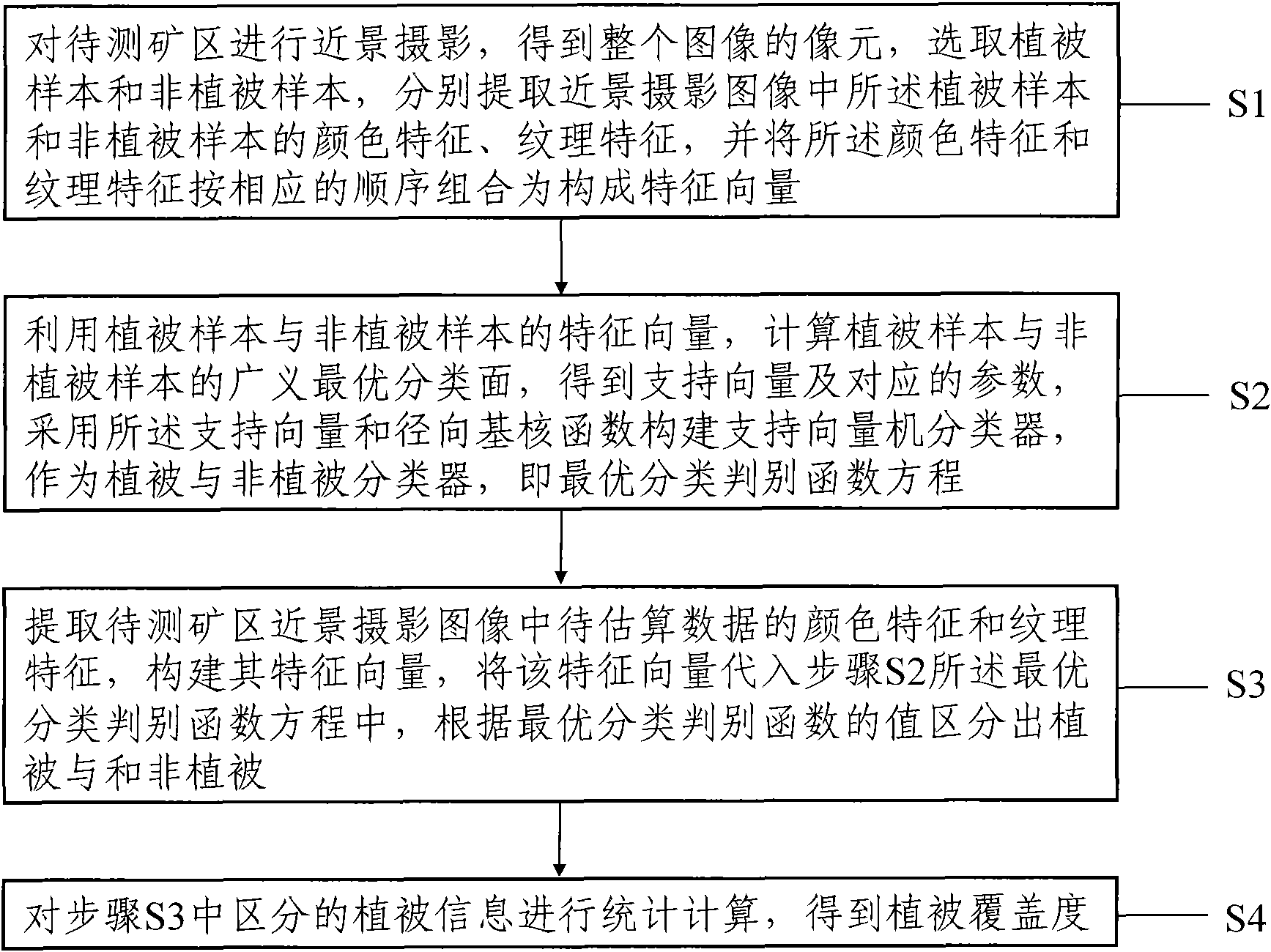
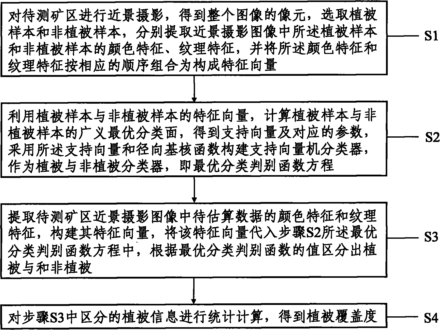
[0067] The following examples are used to illustrate the present invention, but are not intended to limit the scope of the present invention. Embodiment 1 The method for estimating mining area vegetation coverage of the present invention

[0068] Taking the vegetation restoration area of ​​Haizhou open-pit mine dump in Fuxin City, Liaoning Province as an example, a 10-megapixel digital camera was used to take pictures in this area, with a quadrat size of 1m*1m. 200 pictures were taken, and 300 pictures were taken vertically downwards. At the same time, accurate visual estimation of the vegetation coverage was carried out in the photographed area. The results show that the deviation between this method and strict visual estimation is very small, most of the deviations are below 5%, and the largest deviation is only 7.6%.

[0069] The flow diagram of the method for estimating the vegetation coverage in mining areas based on close-range photogrammetry in the present invention ca...

Embodiment 2

[0110] Embodiment 2 The system for estimating the vegetation coverage in mining area of ​​the present invention

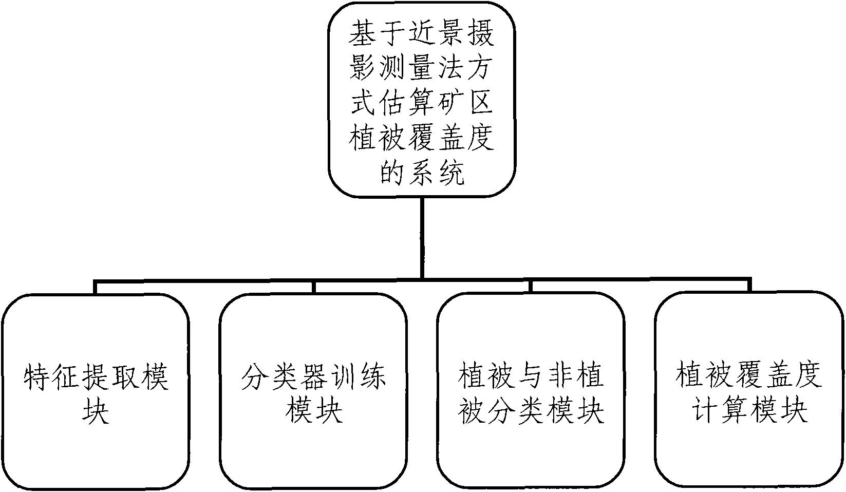
[0111] The system for estimating vegetation coverage in mining areas based on close-range photogrammetry in the present invention includes a feature extraction module, a classifier training module, a vegetation and non-vegetation classification module, and a vegetation coverage calculation module. For a schematic diagram of its structure, see figure 2 .

[0112] 1. Feature extraction module

[0113] It is used to extract the color features and texture features of the image and form a feature vector. The image contains vegetation samples, non-vegetation samples, and data to be estimated; the color features include red, green, blue, brightness and The red average value, green average value, and blue average value of the 3 × 3 square matrix centered on the pixel; the texture features include the standard deviation and contrast of the 5 × 5 square matrix centered on ...


PUM


Abstract

The invention relates to a method for estimating vegetation coverage degree in diggings based on a close-up photography mode. The method comprises the following steps of: photographing the diggings to be tested, extracting color features and texture features to form a feature vector according to a particular order, fast classifying vegetation and non-vegetation utilizing a support vector machine classifier, then gathering statistics of vegetation information, and then fast and accurately calculating the vegetation coverage degree for providing reliable basis for surveying the growth status of the vegetation in the diggings. The method also can be used as actual verification of quantitative remote sensing estimation of vegetation coverage algorithm at the same time. The invention also relates to a system for estimating the vegetation coverage degree in the diggings based on the close-up photography mode. The system comprises a feature extraction module, a classifier training module, a vegetation and non-vegetation classifying module and a vegetation coverage degree calculating module.

Description

technical field [0001] The invention relates to the measurement of vegetation coverage, in particular to a method and system for estimating the vegetation coverage of mining areas based on close-range photogrammetry. Background technique [0002] The mining of mining resources has caused increasingly serious ecological and environmental problems in mining areas. Large-scale mining of mineral resources will inevitably cause damage to vegetation and soil; open-pit mining, ground subsidence, and the accumulation of waste from mineral processing have produced a large number of mining wasteland. It has caused serious soil erosion and environmental pollution to the local area, thus affecting the development of local economic construction. In order to improve the ecological environment of the mining area and effectively utilize the mining wasteland, it is necessary to carry out ecological restoration of the mining wasteland, and vegetation restoration plays an extremely important r...

Claims


Application Information

Patent Timeline
IPC IPC(8): G01C11/00G01C11/04G06K9/46G06T7/00G06K9/62
CPCG06K9/00664G06K9/00697G06V20/38G06V20/10G06V20/188
Inventor 李道亮苏伟邹晓晨陈英义李俐
Owner CHINA AGRI UNIV
Learn More