Method for reconstructing radar scanning data to generate three-dimensional visual terrain

A technology of three-dimensional terrain and radar scanning, which is applied in the directions of radio wave reflection/re-radiation, utilization of re-radiation, and measurement devices, can solve the problems of three-dimensional terrain reconstruction and visualization technology of three-coordinate radar system that have not yet been seen, and achieve Realistic and dynamic terrain display effect, elimination of noise and dead pixels, low requirements for system resources

Inactive Publication Date: 2010-11-10
10TH RES INST OF CETC
View PDF4 Cites 22 Cited by
  • Summary
  • Abstract
  • Description
  • Claims
  • Application Information

AI Technical Summary

Problems solved by technology

[0006] At present, two-dimensional lattice is mainly used to express the data of the three-coordinate radar system, and there is no publ

Method used


Image

  • Method for reconstructing radar scanning data to generate three-dimensional visual terrain
  • Method for reconstructing radar scanning data to generate three-dimensional visual terrain
  • Method for reconstructing radar scanning data to generate three-dimensional visual terrain

Examples


Embodiment Construction

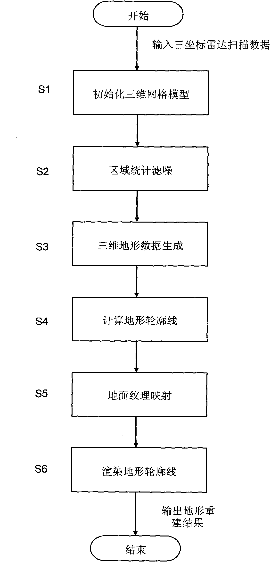
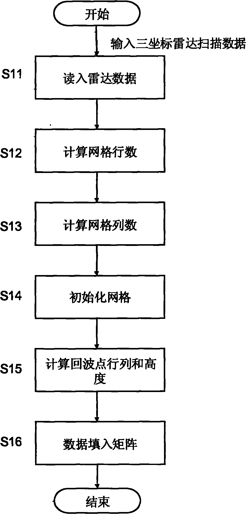
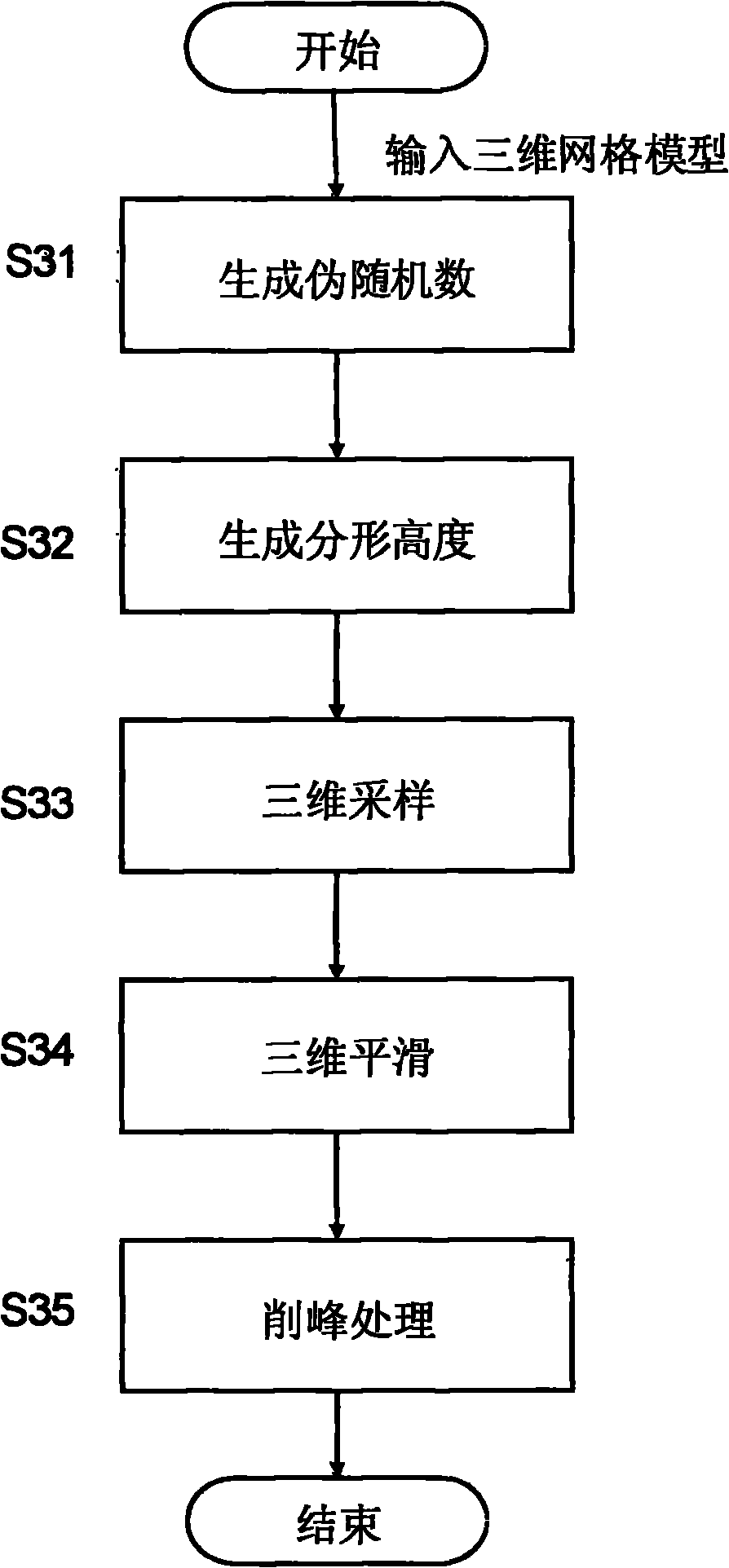
[0024] refer to figure 1 . exist figure 1 In the described three-dimensional terrain reconstruction and visualization process for the data of the three-coordinate radar system, when the three-coordinate radar scan data is input, the data to be processed scanned by the three-coordinate radar system is read into the computer memory by step S1, and the computer reads the data scanned by the three-coordinate radar system into the computer memory. The size and resolution of the radar scanning area are used to construct a three-dimensional grid model, that is, the number of scanning units in the azimuth angle of the radar scanning area is used as the row dimension, and the number of distance units is used as the column dimension to establish a matrix. The grid node is zero, and the 3D grid model is initialized according to the three-coordinate radar scanning data to generate a predetermined height surface. In step S2, the computer counts the number of radar echo points in the area...


PUM


Abstract

The invention provides a method for reconstructing radar scanning data to generate visual three-dimensional terrain. By utilizing the method, three-dimensional terrain data obtained by the scanning of a three-dimensional radar can be reconstructed and displayed in real time. The method is implemented through the following technical scheme of: constructing a three-dimensional gridding module according to the size and resolution power of a scanning area of the three-dimensional radar, and initializing according to radar scanning data to generate a preset height surface; performing the statistical noise filtering of a region to remove the noise and dead spots of a radar system; interpolating empty data by using a constrained adaptive fractal extension method to generate the continuous and realistic three-dimensional terrain data and control the approximate shape of generated terrain to a certain degree; calculating the terrain data by utilizing a mode of six-degree of freedom voxel to form terrain contour lines in different visual angles; and completing ground texture mapping by loading mixed texture mapping with a fractal mode, and completing the rendering of the terrain contour lines by a gradient mode of luminance-height-gradient so as to generate a final three-dimensional terrain image.

Description

technical field [0001] The present invention relates to three-dimensional data field reconstruction and visualization technology in the field of computer vision. More specifically, the present invention relates to a method for visually displaying three-dimensional geographic figures for three-dimensional terrain reconstruction using three-coordinate radar system data. Background technique [0002] Using the data of the three-coordinate radar system to reconstruct and visualize the three-dimensional terrain, an intuitive and vivid description and display of the radar scanning scene can be obtained. Using this technology, it can effectively support terrain perception and warning systems and obstacle detection systems in military and civilian fields. [0003] Traditional radar display systems can only provide two-dimensional images to combatants, and it is difficult to intuitively reflect terrain and target information. In modern and future combat requirements, various reconna...

Claims


Application Information

Patent Timeline
IPC IPC(8): G01S13/89
Inventor 俞鸿波
Owner 10TH RES INST OF CETC
Why Eureka
Try Eureka