Navigation method and device

A navigation method and a technology of a navigation device, which are applied in the field of navigation and can solve problems such as the inability to use GPS satellite signals

Inactive Publication Date: 2011-01-19
CARELAND TECH SHENZHEN
View PDF3 Cites 7 Cited by
  • Summary
  • Abstract
  • Description
  • Claims
  • Application Information

AI Technical Summary

Problems solved by technology

[0008] The technical problem to be solved by the present invention is to provide a navigation method and device that can provide navigation services when GPS satellite signals cannot be used for navigation.

Method used


Image

  • Navigation method and device
  • Navigation method and device
  • Navigation method and device

Examples


Embodiment Construction

[0041] In order to make the object, technical solution and advantages of the present invention clearer, the present invention will be further described in detail below in conjunction with the accompanying drawings and embodiments. It should be understood that the specific embodiments described here are only used to explain the present invention, not to limit the present invention.
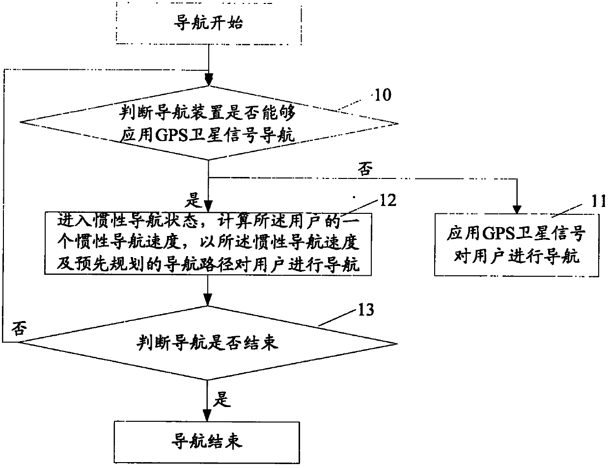
[0042] The core idea of ​​the present invention is that when the GPS satellite signal cannot be used for navigation, it enters the inertial navigation state, and uses the inertial navigation speed and the pre-planned navigation path to navigate the user.

[0043] Refer to attached figure 1 , is a flowchart of a navigation method in an embodiment of the present invention. After the navigation starts, the navigation method in this embodiment specifically includes the following steps:

[0044] Step 10: judging whether the navigation device can use GPS satellite signal navigation;

[0045] If GPS sat...


PUM


Abstract

The invention relates to a navigation method in the technical field of navigation, comprising the following steps of: A: judging whether a navigation device can apply GPS (Global Position System) satellite signal navigation or not; if so, executing a step B, and if not, executing a step C; B: applying a GPS satellite signal to navigate a user; and C: entering an inertial navigation state, calculating one inertial navigation speed of the user, and navigating the user at the inertial navigation speed according to a pre-mapped navigation path. The embodiment of the invention further provides a corresponding navigation device. The technical scheme of the invention can be used for navigation service when the GPS satellite signal cannot be used for navigation, and solve the problems of high manufacture cost, large size and inconvenient carrying of the traditional navigation device formed by special mechanical or electronic devices, such as an accelerometer, a gyroscope, and the like.

Description

technical field [0001] The invention belongs to the technical field of navigation, and in particular relates to a navigation method and device when GPS satellite signals cannot be used for navigation. Background technique [0002] Currently, a vehicle-mounted global positioning system (Global Positioning System, GPS) has been widely used in daily work and life. The user sets the starting point, destination, necessary places, avoiding places, etc. in the navigation system, and the navigation system plans an appropriate route according to the user's settings, and displays it for the user's reference. [0003] Existing GPS navigation devices all realize GPS navigation by receiving GPS satellite signals and processing the GPS satellite signals through a GPS module. When the GPS satellite signal strength is not enough to meet the needs of navigation or there is no satellite signal for a certain period of time, it is impossible to provide accurate navigation services. For example...

Claims


Application Information

Patent Timeline
Patent Type & Authority Applications(China)
IPC IPC(8): G01C21/34G01S19/39
Inventor 张文星
Owner CARELAND TECH SHENZHEN
Why Eureka
Try Eureka