Device for acquiring inversion significant wave height and relative elevation in delay mapping receiver

A technology of effective wave height and delay mapping, which is applied in the direction of measuring devices, radio wave measurement systems, satellite radio beacon positioning systems, etc., to achieve the effect of fast processing speed

Inactive Publication Date: 2011-02-16
BEIHANG UNIV
View PDF4 Cites 15 Cited by
  • Summary
  • Abstract
  • Description
  • Claims
  • Application Information

AI Technical Summary

Problems solved by technology

[0004] Fast Fourier transform (FFT) has been applied in processing the capture of direct GPS signals, but it has not been applied in processing GPS reflected signals. With the continuou

Method used


Image

  • Device for acquiring inversion significant wave height and relative elevation in delay mapping receiver
  • Device for acquiring inversion significant wave height and relative elevation in delay mapping receiver
  • Device for acquiring inversion significant wave height and relative elevation in delay mapping receiver

Examples


Embodiment Construction

[0051] The present invention will be further described in detail below in conjunction with the accompanying drawings.

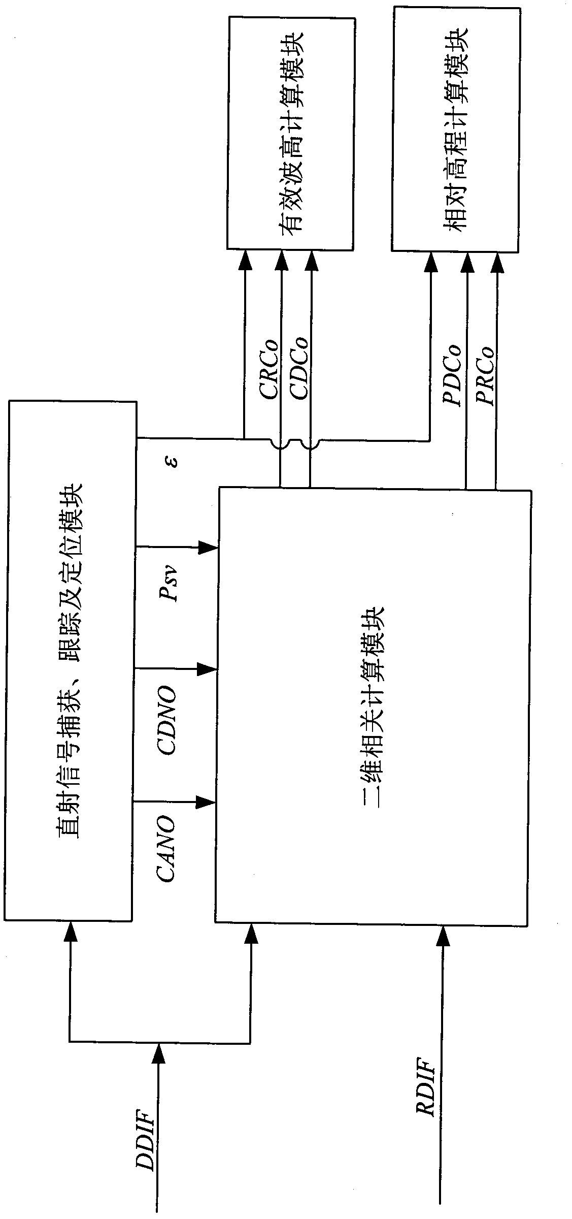
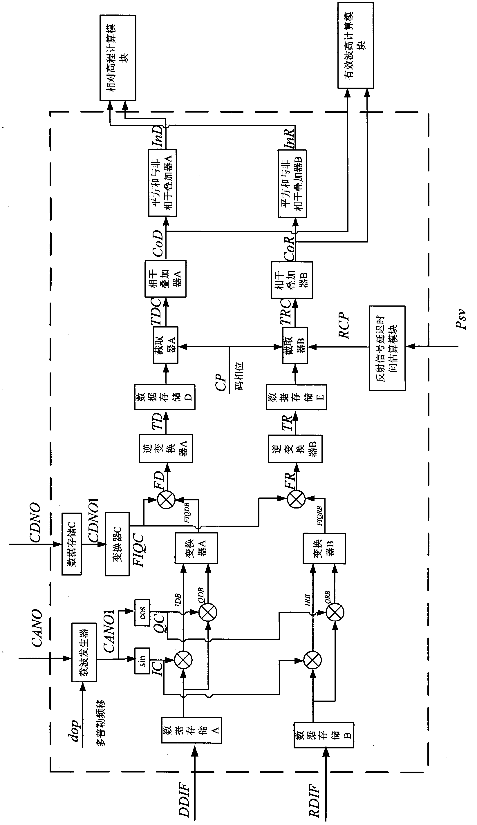
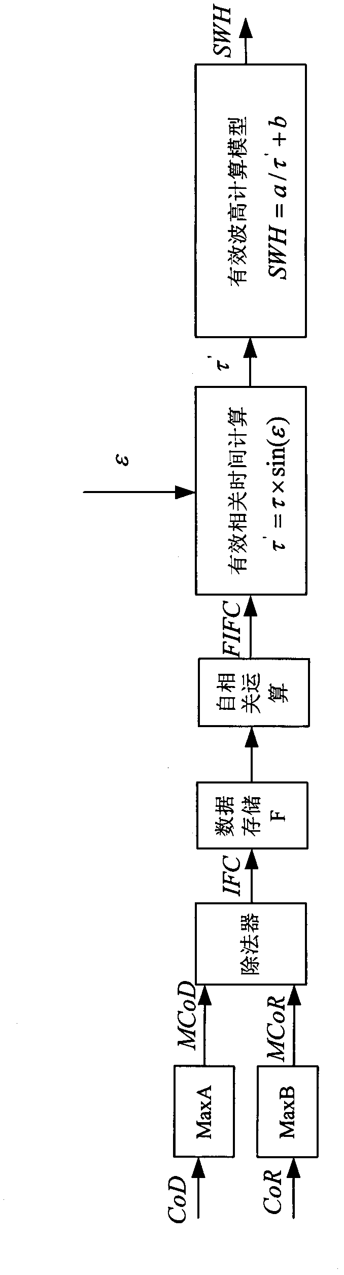
[0052] see figure 1 As shown, the present invention is an acquisition device suitable for inversion effective wave height and relative elevation in a delay mapping receiver, the device includes a direct signal acquisition, tracking and positioning module, a two-dimensional correlation calculation module, an effective wave height calculation module and Relative elevation calculation module.

[0053] (1) Direct signal acquisition, tracking and positioning module

[0054] The direct signal capture, tracking and positioning module is processed by the document "FPGA Realization of GPS Receiver Baseband Signal Processing Module" published in "Telemetry and Remote Control" in July 2006, Volume 27, Issue 4, and the carrier frequency CANO and code phase are respectively obtained. CDNO, navigation and positioning solution Psv and satellite elevation angle ε. Among ...


PUM


Abstract

The invention discloses a device for acquiring inversion significant wave height and relative elevation in a delay mapping receiver, which comprises a direct signal acquisition, tracking and module, a two-dimensional correlation computation module, a significant wave height computation module and a relative elevation computation module. In the invention, a frequency domain processing method is used for processing a direct digital intermediate frequency signal DDIF and a reflected digital intermediate frequency signal RDIF to obtain two-dimensional correlation values CDCo and CRCo, and two-dimensional correlation power values PDCo and PRCo of the satellite direct signal and sea reflected signal; an interference complex field processing method is used for processing CDCo, CRCo and epsilon to obtain the sea surface significant wave height SWH; and a peak value following processing method is used for processing PDCo, PRCo and epsilon to obtain a relative elevation H from delay mapping receiver to sea surface.

Description

technical field [0001] The present invention relates to an ocean remote sensing device, more particularly, an acquisition device suitable for inversion of effective wave height and relative elevation in a delay mapping receiver. Background technique [0002] The global positioning system not only provides navigation and positioning information for space information users, but also provides a steady stream of L-band microwave signal resources. In the past ten years, GPS-R remote sensing technology has developed rapidly. By receiving direct satellite signals and sea surface reflection signals, and using correlation processing, the correlation function waveform of C / A code is obtained, and then element inversion is carried out, which can be used for sea surface wind Field inversion, ocean salinity measurement, sea surface elevation measurement, ground humidity distinction, terrain height early warning, etc. [0003] Existing delay mapping receivers or Doppler delay mapping rec...

Claims


Application Information

Patent Timeline
IPC IPC(8): G01S19/35
Inventor 杨东凯李明里吴红甲张波李伟强
Owner BEIHANG UNIV
Why Eureka
Try Eureka