WebGIS (Web Geographic Information System)-based system for displaying real-time state of intelligent transportation equipment

An intelligent transportation and display system technology, applied in the field of intelligent transportation, can solve the problems that the standard symbol size cannot be enlarged or reduced accordingly, unfavorable software upgrade and maintenance, poor user experience, etc.

Active Publication Date: 2014-01-22
SHANGHAI BAOSIGHT SOFTWARE CO LTD
View PDF6 Cites 0 Cited by
  • Summary
  • Abstract
  • Description
  • Claims
  • Application Information

AI Technical Summary

Problems solved by technology

[0005] (1) C / S software requires the installation of client software, which is not conducive to software upgrades and maintenance;
[0006] (2) The real-time performance is poor, and the status update period is greater than 30 seconds; when the device status is updated, the entire GIS interface will refresh and flash;
[0007] (3) The standard symbol cannot represent the device vividly; when the map is enlarged or reduced, the size of the standard symbol cannot be enlarged or reduced accordingly, and the phenomenon of imbalance between the symbol size and the map ratio often occurs, and the user experience is poor;
However, since this method cannot be combined with GIS, it is impossible to intuitively locate the equipment status information to the equipment location information

Method used


Image

  • WebGIS (Web Geographic Information System)-based system for displaying real-time state of intelligent transportation equipment

Examples


Embodiment Construction

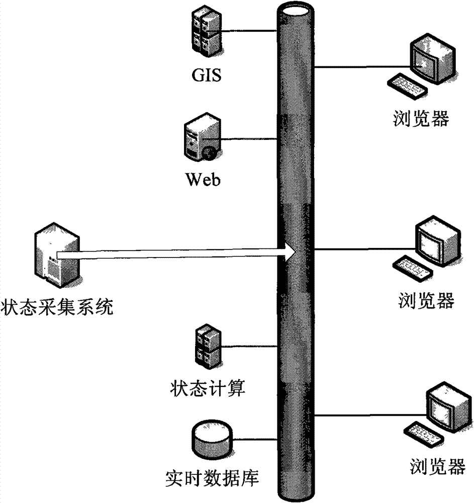
[0020] An embodiment of the WebGIS-based real-time status display system for intelligent transportation equipment of the present invention figure 1 As shown, including state acquisition system, GIS server, WEB server, state calculation server, real-time database, World Wide Web, browser;

[0021] The state collection system collects the state information of the intelligent transportation equipment, and transmits the state information of the intelligent transportation equipment to the World Wide Web;

[0022] The state calculation server receives the state information of the intelligent transportation equipment through the World Wide Web and performs calculation processing, judges its current state, and stores the calculation results in the real-time database through the World Wide Web;

[0023] The GIS server uses WebGIS technology to dynamically generate GIS pictures in real time;

[0024] The WEB server uses Ajax technology to obtain the size of the map display area of ​​th...


PUM


Abstract

The invention discloses a WebGIS (Web Geographic Information System)-based system for displaying the real-time state of intelligent transportation equipment. Combined with the WebGIS technology, the Ajax technology and the Javascript technology, the GIS technology is adopted for a background server to dynamically generate a GIS map picture and acquire the position information, the category information and the state information of the intelligent transportation equipment by utilizing a B / S (Browser) frame; the Ajax technology and the Javascript technology are adopted for a foreground server to dynamically generate an icon of the intelligent transportation equipment according to the category information and the state information of the site intelligent transportation equipment, to superpose the icon of the intelligent transportation equipment and the GIS map picture according to the geographic position information of the site intelligent transportation equipment and to display the real-time state of the intelligent transportation equipment on a WebGIS page. The invention can be used for locating the site intelligent transportation equipment quickly and accurately and displaying the state information thereof in real time.

Description

technical field [0001] The invention relates to intelligent transportation technology, in particular to a real-time status display system for intelligent transportation equipment based on WebGIS. Background technique [0002] With the development of the city, more and more intelligent transportation devices are placed at various intersections or road sections in the city. How to grasp the real-time operation status of these devices in a timely and rapid manner, and reduce or avoid the impact on road traffic due to equipment failure or abnormality has become an issue. become a difficult problem for traffic managers. [0003] At present, the real-time status display system of intelligent transportation equipment based on WebGIS (World Wide Web Geographic Information System) adopts the following technical solutions: [0004] 1. Use the GIS control provided by the GIS (geography information system, geographic information system) software manufacturer to develop C / S (client / serv...

Claims


Application Information

Patent Timeline
Patent Type & Authority Patents(China)
IPC IPC(8): G08G1/097H04L29/06
Inventor 刘其峰尹一瓴曾炜李东晓
Owner SHANGHAI BAOSIGHT SOFTWARE CO LTD
Why Eureka
Try Eureka