Spatial three-dimension (3D) measurement method based on laser point cloud and digital measurable images

A laser point cloud and three-dimensional measurement technology, applied in the field of three-dimensional measurement of space objects, can solve the problems of slow access to massive point cloud data, limited popularization of lidar technology, and cumbersome processing. Distortion, avoid the effect of focal length change

Inactive Publication Date: 2012-11-07
扬州德可达科技有限公司
View PDF0 Cites 0 Cited by
  • Summary
  • Abstract
  • Description
  • Claims
  • Application Information

AI Technical Summary

Problems solved by technology

[0007] A method for spatial three-dimensional measurement based on laser point cloud and real-scene images of the present invention solves technical problems including: slow access speed, cumbersome processing, and difficult operation of massive point cloud data acquired by the mobile laser radar system; The limited popularization of lidar technology caused by people's cognitive limitations of point cloud data

Method used


Image

  • Spatial three-dimension (3D) measurement method based on laser point cloud and digital measurable images
  • Spatial three-dimension (3D) measurement method based on laser point cloud and digital measurable images

Examples


Embodiment Construction

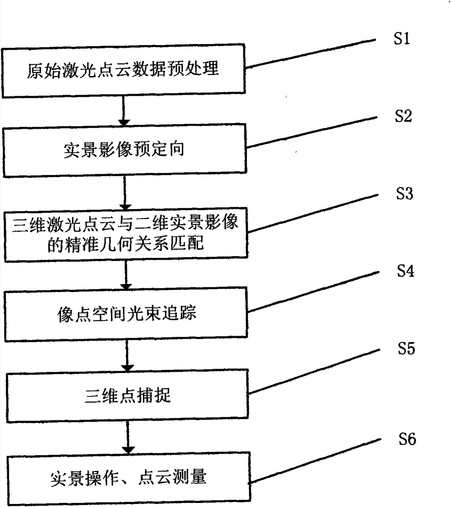
[0030] figure 1 It is a flow chart of a method for spatial three-dimensional measurement based on laser point cloud and real scene images of the present invention, and the specific steps include:

[0031] Step S1: Raw laser point cloud data preprocessing

[0032] The preprocessing of the original laser point cloud data can generally be completed by the data preprocessing software that comes with the hardware device, and the three-dimensional geodetic coordinates of the laser point cloud can be calculated by combining the positioning and orientation data of the laser scanner;

[0033] Step S2: Live image pre-orientation

[0034] Combining the positioning and orientation data of the digital imaging equipment obtained by differential GPS and IMU and the system calibration value, the initial external orientation elements of each real-scene image are derived;

[0035] Step S3: Accurate geometric relationship matching between 3D laser point cloud and 2D real scene image

[0036] ...


PUM


Abstract

The invention relates to the field of spatial information data processing, in particular to a space object three-dimension (3D) measurement method based on high-precision and high-density laser point cloud and digital measurable images which are obtained by a movable measurement system. The method is characterized by comprehensively utilizing the laser point cloud and digital measurable image data which are obtained by a movable laser radar system, taking the high-precision and high-density laser 3D point cloud as the actual acquisition target and identifying and operating the target with thehelp of the digital measurable images to achieve the aim of precise measurement of the 3D objects. The method has the following beneficial effects: a brand-new concept of measuring real objects by observing real scenes is put forward; the advantages of high density and high precision of the laser point cloud and easy identification and operation of the digital measurable images are fully utilizedto realize global operation based on the digital measurable images and local precise measurement based on the laser point cloud, thus effectively solving the problems of slow access, fussy processingand difficult operation of massive point cloud data; and popularization and application of laser radar technology are promoted.

Description

technical field [0001] The invention relates to the field of spatial information data processing, in particular to a method for three-dimensional measurement of space objects based on high-precision, high-density laser point clouds and real scene images acquired by a mobile measurement system. Background technique [0002] At present, the mobile measurement systems used in the international market can be divided into two types, one is based on the traditional three-dimensional photogrammetry principle, and the other is based on the modern high-precision, high-frequency laser scanning principle. [0003] 1. Mobile Stereo Photogrammetry System [0004] The mobile stereo photogrammetry system is based on the traditional stereo photogrammetry principle, that is, by measuring the parallax comparison (coordinate difference) between two image points (points with the same name) of an object point in the space on the stereo image pair to realize the spatial coordinates of the object....

Claims


Application Information

Patent Timeline
Patent Type & Authority Patents(China)
IPC IPC(8): G01C11/00G01S17/06G01S17/89
Inventor 唐粮
Owner 扬州德可达科技有限公司
Why Eureka
Try Eureka