Fusion method of multispectral remote sensing images with different spatial resolutions

A remote sensing image fusion and multi-spectral image technology, applied in the field of multi-spectral remote sensing image fusion, can solve the problem of low resolution and achieve the effect of clear texture

Active Publication Date: 2011-07-06
BEIJING RES INST OF URANIUM GEOLOGY
View PDF6 Cites 22 Cited by
  • Summary
  • Abstract
  • Description
  • Claims
  • Application Information

AI Technical Summary

Problems solved by technology

[0003] At present, the sensors carried by high spatial resolution remote sensing satellites such as IKONOS and QuickBird can collect multispectral images with higher spatial resolution, but only have multispectral information of three to four bands, while the data of TM, Aster and Hyperion have relatively a lot of spectral information, but its resolution is very low

Method used


Image

  • Fusion method of multispectral remote sensing images with different spatial resolutions
  • Fusion method of multispectral remote sensing images with different spatial resolutions
  • Fusion method of multispectral remote sensing images with different spatial resolutions

Examples


Embodiment Construction

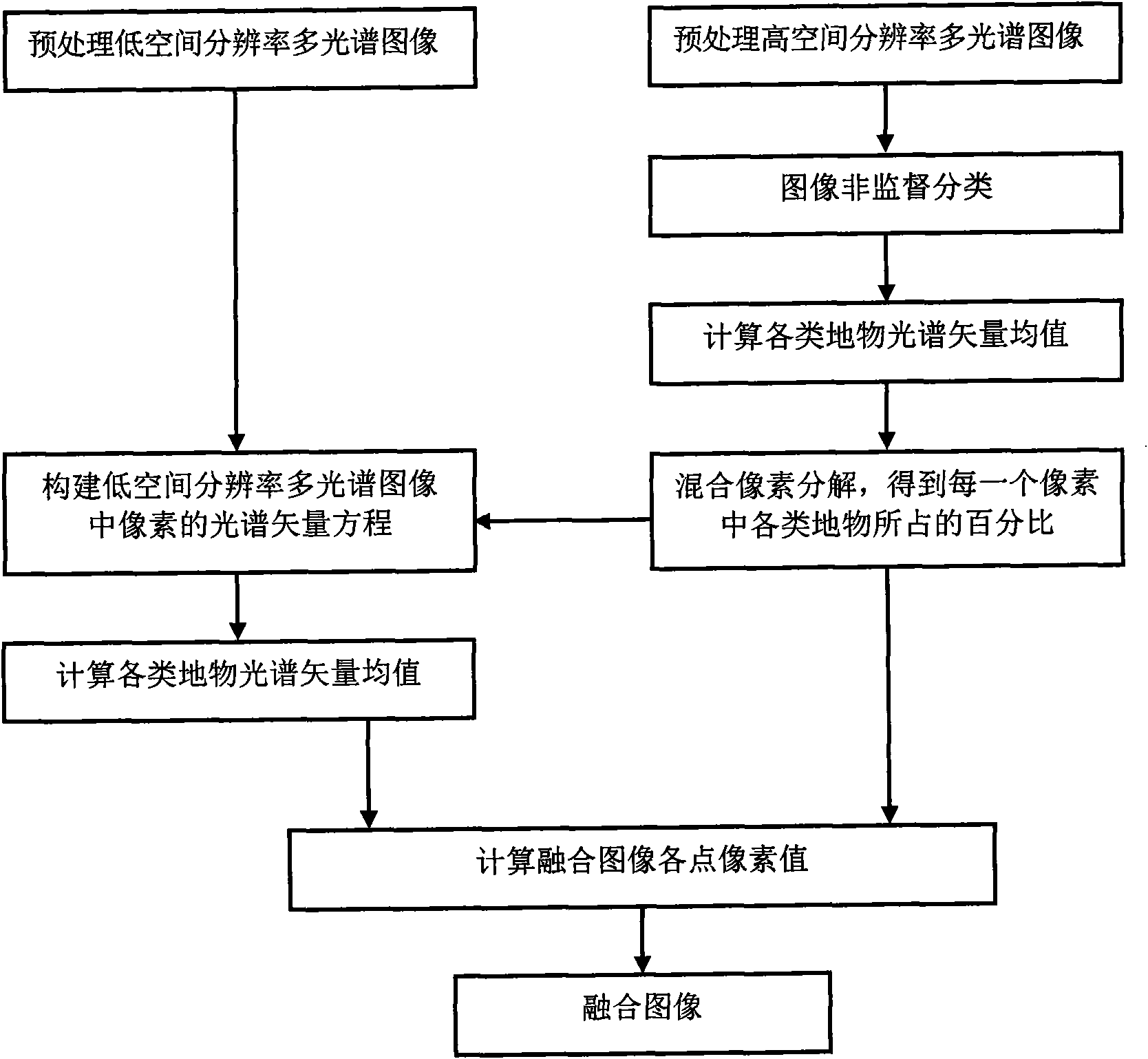
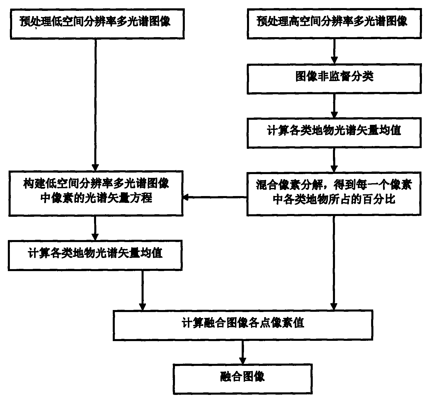
[0027] The present invention will be described in detail below in conjunction with the accompanying drawings and embodiments.

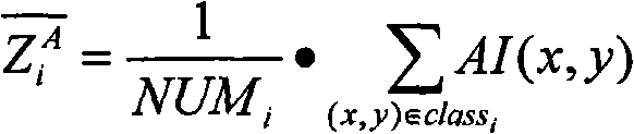
[0028] For the convenience of description, let A represent the high spatial resolution multispectral image of a certain area, AI(x, y) is the spectral vector at row x, column y, then AI(x, y)={A 1 (x, y), A 2 (x,y)...A l (x, y)}; B represents the multispectral image of low spatial resolution in the same area, BI (x, y) is the spectral vector at the yth column of the xth row, then BI (x, y) = {B 1 (x, y), B 2 (x,y)...B p (x, y)}.

[0029] As shown in Figure 1, the multispectral remote sensing image fusion method with different spatial resolutions provided by the present invention comprises the following steps:

[0030] Step 1) Perform preprocessing denoising and registration on the high spatial resolution multispectral images and low spatial resolution multispectral images of the same region. In this step, the commonly used denoising and registra...


PUM


Abstract

The invention belongs to the field of remote sensing image processing, and particularly relates to a fusion method of multispectral remote sensing images with different spatial resolutions. The method comprises the steps of dividing the multispectral image with high spatial resolution into n types of surface features, calculating the spectral vector mean value of all types of the surface features in the multispectral image with high spatial resolution, then conducting mixed pixel decomposition on the multispectral image with high spatial resolution, showing the multispectral image with low spatial resolution by the percent of all types of surface features in each pixel of the multispectral image with high spatial resolution, solving the spectral vector mean value of all types of the surface features in the multispectral image with low spatial resolution, and finally calculating the pixel value of each pixel of a fused image and generating the fused image. The method can fuse the multispectral image with high spatial resolution and the multispectral image with low spatial resolution, and enable the image fused to be sharper.

Description

technical field [0001] The invention belongs to the field of remote sensing image processing, and in particular relates to a multispectral remote sensing image fusion method with different spatial resolutions. Background technique [0002] At present, various fusion algorithms generally solve the problem of underdetermination of equations caused by insufficient known conditions in the fusion process by establishing appropriate fusion models. For example, in the IHS transformation method, firstly, the multispectral image is sampled to the same size as the panchromatic image through an interpolation algorithm. Then the spectral information and intensity information of the image are separated, and the intensity information and spectral information are inversely transformed into a fusion image with a panchromatic image. In the fusion process, the spectral information of the fused image (shown as the color of the image in the image) is obtained by interpolating the multispectral ...

Claims


Application Information

Patent Timeline
Patent Type & Authority Applications(China)
IPC IPC(8): G06T5/50G06T5/00
Inventor 陆冬华赵英俊
Owner BEIJING RES INST OF URANIUM GEOLOGY
Why Eureka
Try Eureka