Golf cart navigation system based on acceleration transducer

An acceleration sensor, golf cart technology, applied in radio wave measurement systems, satellite radio beacon positioning systems, instruments, etc., can solve problems such as signal error and drift, avoid static drift, prevent users from shutting down, and facilitate advertising playback Effect

Inactive Publication Date: 2011-08-03
上海同想文化传播有限公司
View PDF5 Cites 10 Cited by
  • Summary
  • Abstract
  • Description
  • Claims
  • Application Information

AI Technical Summary

Problems solved by technology

In places with dense tall buildings or bad weather conditions, the GPS signal has been refracted and reflected many times, resulting in signal errors and more obvious drift.

Method used


Image

  • Golf cart navigation system based on acceleration transducer
  • Golf cart navigation system based on acceleration transducer
  • Golf cart navigation system based on acceleration transducer

Examples


Embodiment Construction

[0023] The present invention will be further described below in conjunction with the accompanying drawings and embodiments.

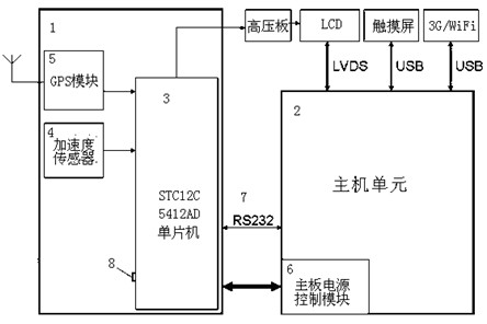
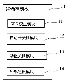
[0024] figure 1 It is a schematic diagram of the structure of the golf cart navigation system based on the acceleration sensor of the present invention; figure 2 It is a structural block diagram of the software control module on the terminal control board of the present invention.

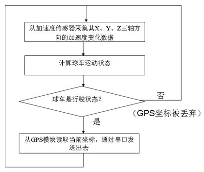
[0025] See figure 1 with figure 2 , the golf cart navigation system based on the acceleration sensor of the present invention includes a host unit 2 and a terminal control board 1, and the terminal control board 1 includes a single-chip microcomputer 3, wherein the single-chip microcomputer 3 is connected to the GPS module 5 and the acceleration sensor 4 respectively, The GPS correction module 11 on the single-chip computer accepts the signals of the acceleration sensor 4 and the GPS module 5, and when the detection acceleration sensor 4 obtains that the golf cart is in...


PUM


Abstract

The invention discloses a golf cart navigation system based on an acceleration transducer, which comprises a host unit and a terminal control board, wherein the host unit and the terminal control board are connected by data interfaces, the terminal control board consists of a single chip microcomputer, the single chip microcomputer is respectively connected with a GPS (Global Positioning System) module and the acceleration transducer, a GPS correction module on the single chip microcomputer can receive signals from the acceleration transducer and the GPS module, and when the acceleration transducer provides a state that a golf cart stops, the GPS correction module discards positioning information from the GPS module. The golf cart navigation system based on the acceleration transducer, provided by the invention, effectively avoids static drifting of a GPS by the acceleration transducer, and realizes automatic power-on and power-off of a terminal by virtue of the acceleration transducer to determine whether the golf cart stops.

Description

technical field [0001] The invention relates to a golf cart navigation system, in particular to a golf cart navigation system based on an acceleration sensor. Background technique [0002] The full name of GPS is Global Positioning System, which is the abbreviation of Global Positioning System in English. It was first successfully developed by the United States. It is the second-generation satellite navigation system in the United States (Russia also has a similar system, and its name is Glonass). The global positioning system consists of three parts: the space part, the ground monitoring part and the user receiver. The core space part uses 24 satellites with a height of about 20,200 kilometers to form a satellite network. These 24 satellites are all in near-circular orbits, with a running period of about 11 hours and 58 minutes, and are distributed on six orbital planes (each orbital plane four satellites) with an orbital inclination of 55 degrees. The continuous distribu...

Claims


Application Information

Patent Timeline
Patent Type & Authority Applications(China)
IPC IPC(8): G01S19/49G01S19/34
Inventor 毛郁葱万琪范文历
Owner 上海同想文化传播有限公司
Why Eureka
Try Eureka