GNSS (Global Navigation Satellite System)/SINS (Ship's Inertial Navigation System) based integrated vehicle navigation monitoring system

A monitoring system and vehicle navigation technology, applied in directions such as road network navigators, to reduce rescue waiting time, have high precision, and ensure accuracy.

Inactive Publication Date: 2013-01-09
ZHEJIANG UNIV
View PDF0 Cites 0 Cited by
  • Summary
  • Abstract
  • Description
  • Claims
  • Application Information

AI Technical Summary

Problems solved by technology

[0016] The invention provides a vehicle navigation monitoring system based on GNSS / SINS combination, which overcomes the defects of GNSS or SINS as a single navigation monitoring system, and calibrates the error of the inertial sensor in SINS in real time. Under this condition, the accuracy of SINS autonomous navigation is guaranteed

Method used


Image

  • GNSS (Global Navigation Satellite System)/SINS (Ship's Inertial Navigation System) based integrated vehicle navigation monitoring system
  • GNSS (Global Navigation Satellite System)/SINS (Ship's Inertial Navigation System) based integrated vehicle navigation monitoring system
  • GNSS (Global Navigation Satellite System)/SINS (Ship's Inertial Navigation System) based integrated vehicle navigation monitoring system

Examples


Embodiment 1

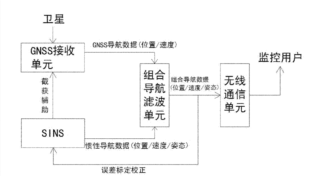
[0041] Such as figure 2 As shown, a vehicle navigation monitoring system based on GNSS / SINS combination includes a GNSS receiving unit, SINS, an integrated navigation filtering unit and a wireless communication unit.

[0042] The GNSS receiving unit is composed of a radio frequency signal processing device, a tracking loop and a GNSS filter, which is used to receive satellite navigation signals about the vehicle body, and process the signals to obtain GNSS navigation data about the position and speed of the vehicle body, and send them to Combined navigation filter unit.

[0043] SINS includes inertial sensors (gyroscopes and accelerometers) and navigation computers, which can autonomously generate inertial navigation data about vehicle body position, velocity, and attitude, and transmit them to the integrated navigation filter unit, while providing interception assistance to the GNSS receiving unit .

[0044] The integrated navigation filtering unit is used to receive GNSS ...

Embodiment 2

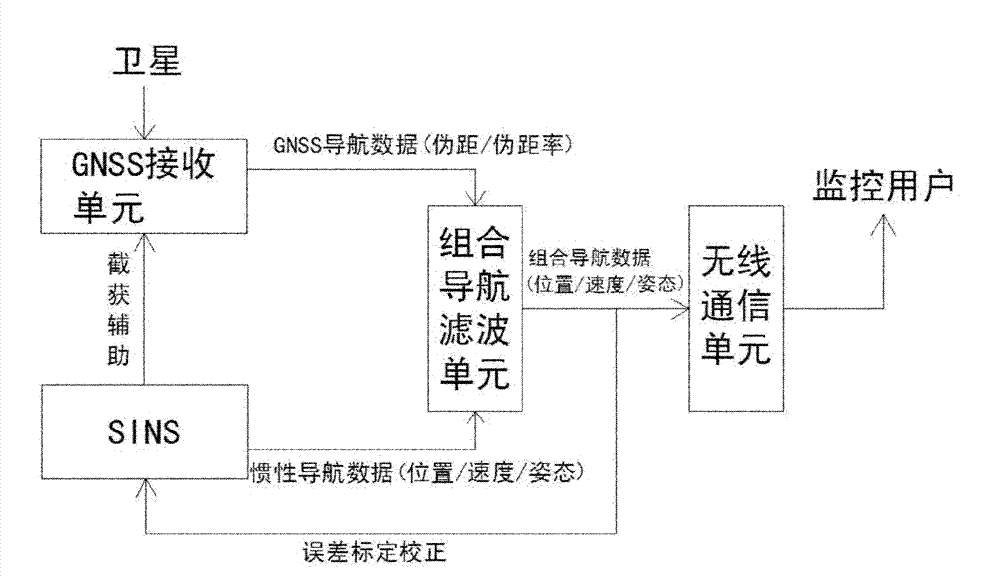
[0082] Such as image 3 As shown, a vehicle navigation monitoring system based on GNSS / SINS combination includes a GNSS receiving unit, SINS, an integrated navigation filtering unit and a wireless communication unit. Wherein the GNSS receiving unit, SINS, integrated navigation filtering unit and wireless communication unit are basically the same as those in Embodiment 1, except that the GNSS filter in the GNSS receiving unit becomes a part of the integrated navigation filtering unit.

[0083] Such as image 3 As shown, the GNSS receiving unit and SINS are combined in a tightly coupled combination mode, and the GNSS filter in the GNSS receiving unit becomes a part of the integrated navigation filtering unit, so the navigation data provided by the GNSS receiving unit to the integrated navigation filtering unit is actually about Measurements of body pseudoranges and pseudorange rates. The integrated navigation data obtained in the tightly coupled combined mode can be used not o...


PUM


Abstract

The invention discloses a GNSS (Global Navigation Satellite System) / SINS (Ship's Inertial Navigation System) based integrated vehicle navigation monitoring system, which comprises a GNSS receiving unit, an SINS, an integrated navigation filter unit and a wireless communication unit, wherein the GNSS receiving unit and the SINS are respectively used for acquiring respective navigation data, the integrated navigation filter unit is used for performing fusion filtering on the data to obtain integrated high-precision navigation data and for calibrating errors of an inertial sensor in the SINS in real time, and the wireless communication unit sends the integrated navigation data to a remote monitoring user through wireless communication, or gives an alarm automatically. In the invention, the defects of the GNSS or the SINS as a single navigation monitoring system are overcome; the accuracy of the SINS for the autonomous inertial navigation is ensured; the navigation data is reported to theremote monitoring user accurately; and therefore, the waiting time for the first aid in an accident is reduced.

Description

technical field [0001] The invention belongs to the technical field of navigation monitoring, in particular to a vehicle navigation monitoring system based on GNSS / SINS combination. Background technique [0002] GNSS (Global Navigation Satellite System) is a system that uses satellite constellations, ground monitoring stations and user receivers distributed in orbits near the earth to achieve global navigation. Satellite navigation systems currently in use and under construction include the GPS (Global Positioning System) of the United States, GLONASS (Glonass) of Russia, COMPASS (Beidou II) of China and Galileo (Galileo) system of Europe. [0003] GPS was originally deployed by the US Department of Defense. After 30 years of construction, it has now fully reached the state of use and can provide global navigation capabilities. The GPS space part consists of a constellation of 24 satellites evenly distributed on six orbital planes with an inclination angle of 55° to the equ...

Claims


Application Information

Patent Timeline
Patent Type & Authority Patents(China)
IPC IPC(8): G01C21/28
Inventor 马龙华管波姚珺袁腾凯冯琼华林灿龙
Owner ZHEJIANG UNIV
Why Eureka
Try Eureka