Intelligent navigation method, device, system and mobile terminal

A technology of intelligent navigation and navigation instructions, applied in the field of navigation, can solve the problems of traffic congestion, inability to provide help, inability to dynamically provide road condition information, and complex map updates, so as to avoid complex map updates.

Inactive Publication Date: 2011-09-14
融创天下(上海)科技发展有限公司
View PDF8 Cites 28 Cited by
  • Summary
  • Abstract
  • Description
  • Claims
  • Application Information

AI Technical Summary

Problems solved by technology

[0005] The purpose of the embodiments of the present invention is to propose a ... method, aiming to solve the problems in the prior art that cann

Method used


Image

  • Intelligent navigation method, device, system and mobile terminal
  • Intelligent navigation method, device, system and mobile terminal
  • Intelligent navigation method, device, system and mobile terminal

Examples


Embodiment 1

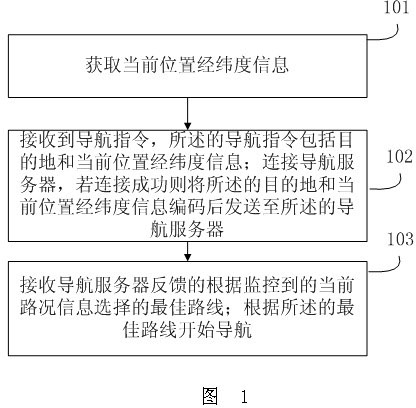
[0029] Embodiment 1, the present invention provides an intelligent navigation method, see figure 1 , the method includes:

[0030] Step 101: Obtain the latitude and longitude information of the current location;

[0031] Step 102: Receive a navigation instruction, the navigation instruction includes the destination and the latitude and longitude information of the current location; connect to the navigation server, if the connection is successful, encode the destination and the latitude and longitude information of the current location and send it to the navigation server ;

[0032] The process of connecting to the navigation server in step 102 can be to connect to the wireless network first, and then connect to the navigation server if the connection is successful, and then start the backup navigation mode if the connection to the wireless network or the navigation server is unsuccessful; the backup navigation mode can be an existing navigation product. The navigation mode ...

Embodiment 2

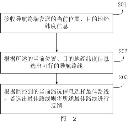
[0040] Embodiment 2, the present invention provides a method for obtaining an intelligent navigation route, see figure 2 , the method is specifically:

[0041] Step 201: receiving the current location, destination latitude and longitude information sent by the navigation terminal;

[0042] Step 202: Selecting a feasible navigation route according to the current location, destination latitude and longitude information;

[0043] Step 203: Select the best route according to the monitored current road condition information, if the best route is selected, then feed back the best route; if the best route is not selected, feed back information such as adjusting navigation instructions, or changing vehicles, etc. .

[0044] The current road condition information may include: weather conditions, whether the road is smooth, traffic volume, whether it is repaired or closed, and other road condition information that affects traffic conditions.

[0045] The "selecting a route according...

Embodiment 3

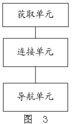
[0048] Embodiment 3, the present invention provides an intelligent navigation device, see image 3 , the intelligent navigation device includes: an acquisition unit, a navigation unit, and a connection unit;

[0049] Acquisition unit: used to obtain the latitude and longitude information of the current location;

[0050] Connection unit: used to receive navigation instructions, the navigation instructions include destination and current location latitude and longitude information; connect to the navigation server, if the connection is successful, encode the destination and current location latitude and longitude information and send them to the navigation server;

[0051] The process of connecting to the navigation server in the connection unit can be to connect to the wireless network first, and then connect to the navigation server if the connection is successful, and then start the backup navigation mode if the connection to the wireless network or the navigation server is u...


PUM


Abstract

The invention provides an intelligent navigation method, which comprises the following steps of: obtaining latitude and longitude information of a current position; receiving a navigation instruction, wherein the navigation instruction comprises latitude and longitude information of a destination and the current position; connecting a navigation server, and if the navigation server is successfully connected, encoding the latitude and longitude information of the destination and the current position and transmitting to the navigation server; receiving a best route selected according to the monitored current road condition information fed back by the navigation server; and starting navigation according to the best route. The navigation is carried out by selecting an appropriate route according to the real-time road condition information, so the traffic congestion can be mitigated to a certain extent; and the road congestion can be predicted according to the historical data so as to shield the road in the rush hour, and the road traffic control can be effectively carried out in cooperation with the traffic police department; and when the monitored road information is changed, a map can be updated in time, so that the problem in the prior art that the map is complicated to update is prevented.

Description

technical field [0001] The present invention relates to the field of navigation, in particular to an intelligent navigation method, device, system and mobile terminal. Background technique [0002] With the continuous improvement of living standards and more and more private cars, the demand for navigators is also increasing. However, the currently used navigation technology generally installs a client with a vector map on the vehicle, obtains the current position of the vehicle through the GPS receiver, and then searches for the nearest navigation route on the map according to the destination information entered by the user. , the prior art mainly has the following disadvantages: [0003] 1. The current navigation map can only provide static information such as the location of the road and the length of the route, but not the weather conditions on the road, the size of the traffic flow, whether it is smooth, whether it is under renovation, whether it is temporarily closed,...

Claims


Application Information

Patent Timeline
IPC IPC(8): G01C21/34G08G1/0968
Inventor 吕建荣
Owner 融创天下(上海)科技发展有限公司
Why Eureka
Try Eureka