
Water level measurement and forecast device using solar photovoltaic power generation system to supply power to water level sensor

A water level sensor, solar photovoltaic technology, applied in signal transmission systems, liquid level indicators for physical variable measurement, instruments, etc., can solve the problems of inaccurate results, inability to rationally allocate water resources in various places, and difficulty.

Inactive Publication Date: 2011-11-23
NANTONG ZONGYI NEW MATERIAL
View PDF8 Cites 7 Cited by
  • Summary
  • Abstract
  • Description
  • Claims
  • Application Information

AI Technical Summary

Problems solved by technology

[0003] In the dry season or rainy season, the water level of the upper, middle and lower reaches of a river often changes. In the past, it was slow, difficult and inaccurate to measure and record the water level manually by walking into the riverbed with a ruler.
[0004] If the water level information of the upper, middle and lower reaches of the river, as well as the water level of lakes and reservoirs cannot be grasped in time, water resources cannot be allocated in a timely and effective manner. Due to global warming, extreme weather phenomena often occur, and it is impossible to continue to use the old methods in the past. Allocate water resources everywhere

Method used


Image

  • Water level measurement and forecast device using solar photovoltaic power generation system to supply power to water level sensor
  • Water level measurement and forecast device using solar photovoltaic power generation system to supply power to water level sensor

Examples


Embodiment 1

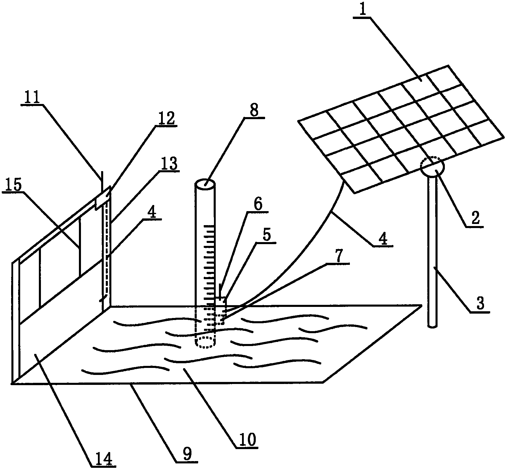
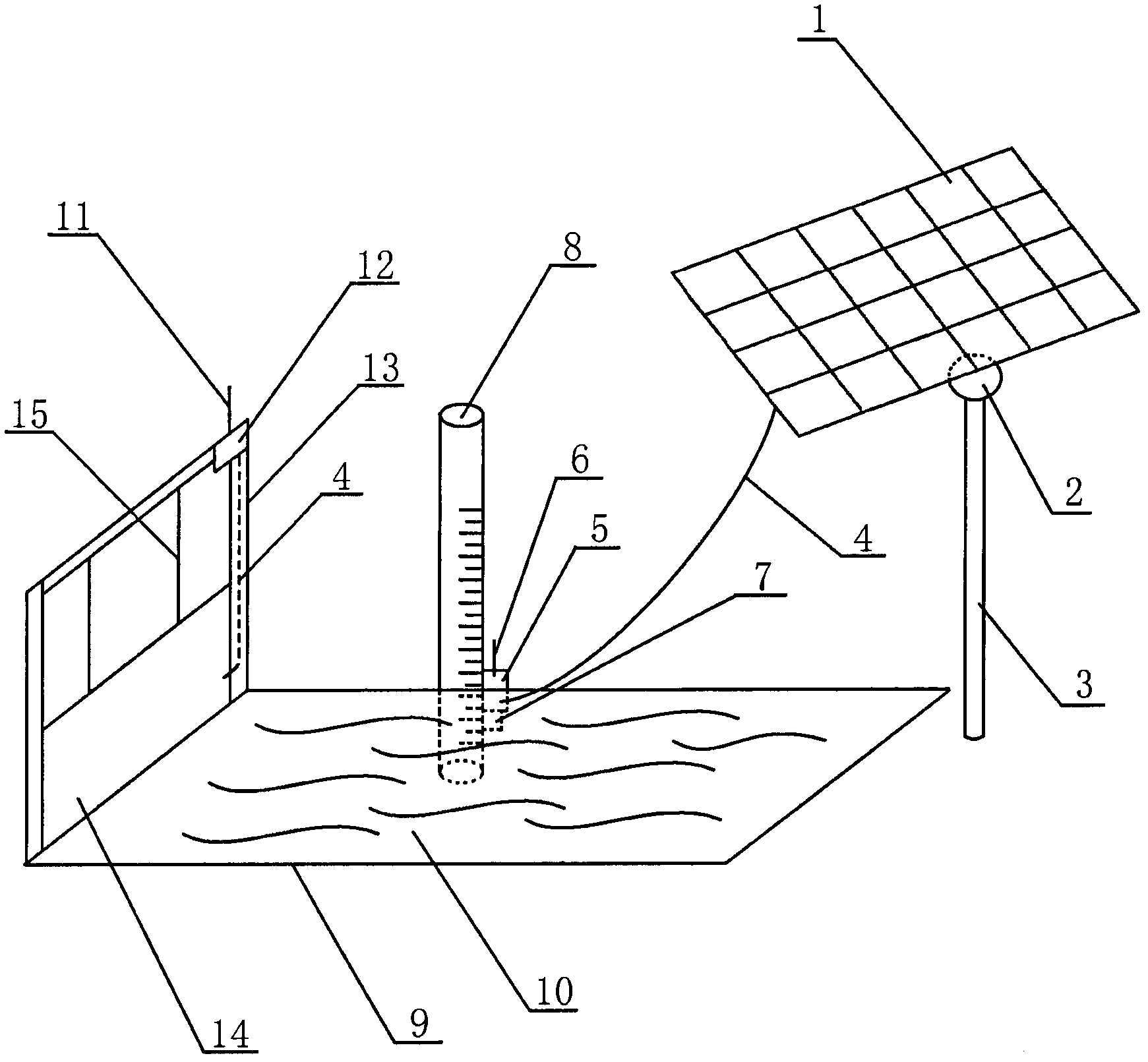
[0018] The upper reaches, the middle reaches and the lower reaches of the same river are divided into three sections, water level scales 8 are respectively erected in the river water 10 of each section of river bed 9, and water level scales 8 can be installed on the edge of each water level scale 8 respectively. A water level sensor 5, a wireless transmitting antenna 6 and a buoyancy device 7 that slide upward or downward. Between the upper reaches and the middle reaches of the river, between the middle reaches and the lower reaches, a gate consisting of a wireless receiving antenna 11, a computer controller 12, a water gate column 13, an electric water gate 14 and an electric cable 15 is constructed. An independent solar photovoltaic power generation system is provided on the bank of each section of the river to directly supply power to nearby water level sensors 5 , wireless transmitting antennas 6 , and buoyancy devices 7 . When the upper reaches of the river run into heavy...

Embodiment 2

[0020] An automatic water gate is built between the outlet of a reservoir and the river bed 9 of the river below the reservoir. In the water layer of the reservoir and the riverbed of the river, water level scales 8 are erected respectively, and water level sensors 5, wireless transmitting antennas 6 and buoyancy devices 7 that can slide upwards or downwards along the edge are respectively installed on the edges of the water level scales 8, when the reservoir When it is necessary to store water and stop releasing water downstream, the water level sensor 5, wireless transmitting antenna 6, and buoyancy device 7 in the reservoir slide down to the horizontal plane along the edge of the water level scale 8 along with the reduction of the water level in the reservoir, and will slide down The water depth, length, and distance of the line are converted into electrical signals, and the information is sent to the air by the wireless transmitting antenna 6. After the wireless receiving a...


PUM


Abstract

The invention relates to a water level measurement and forecast device using a solar photovoltaic power generation system to supply power to a water level sensor, which belongs to the technical field of new energy Internet of things. Sunlight is irradiated to solar cells mounted on a photovoltaic power generation pillar and a sun-chasing device for generating current, the current passes through a conductive wire for supplying the power to a buoyancy device, the water level sensor and a wireless transmitting antenna, when river water rises, the buoyancy device soaked in the river water relies on buoyancy for pushing the water lever sensor and the wireless transmitting antenna to slide along the edge of a water level measuring scale and further rise to the horizontal plane; when the water river falls, the water level sensor, the wireless transmitting antenna and the buoyancy device can slide along the edge of the water level measuring scale by relying on gravity and further fall to the horizontal plane. The water level sensor can convert sensed data of length changes of sliding along the edge of the water level measuring scale due to rising and falling of water level of the water river in a river bed, namely the data of the changes of the water level to electrical signals, and the electrical signals of measurement and forecast of the water level changes are sent into the air through the wireless transmitting antenna.

Description

technical field [0001] The invention relates to a water level measuring and reporting device for a solar photovoltaic power generation system to supply power to a water level sensor, and belongs to the technical field of new energy Internet of Things. Background technique [0002] In 2011, the middle and lower reaches of the Yangtze River in China, including southern Jiangsu Province, Anhui Province, Jiangxi Province, Hubei Province, and Hunan Province, suffered from spring drought. In summer, there was drought first and then flood. The water levels in many rivers, lakes, and reservoirs plummeted. It has caused many difficulties in industrial and agricultural production and people's lives. [0003] In the dry season or rainy season, the water level of the upstream, middle and downstream of a river often changes. In the past, the method of manually walking into the riverbed with a ruler to measure and record the water level was slow, difficult and inaccurate. [0004] If the...

Claims


Application Information

Patent Timeline
IPC IPC(8): G01F23/22G08C17/02
Inventor 缪同春
Owner NANTONG ZONGYI NEW MATERIAL
Learn More