Methods for segmenting and searching remote sensing image

A remote sensing image and image segmentation technology, which is applied in the field of remote sensing image processing, can solve problems such as limited segmentation accuracy

Inactive Publication Date: 2011-11-23
HOHAI UNIV
View PDF4 Cites 39 Cited by
  • Summary
  • Abstract
  • Description
  • Claims
  • Application Information

AI Technical Summary

Problems solved by technology

[0024] The technical problem to be solved by the present invention is to overcome the defect that the existing image segmentation method based on mean shift does not consider the limited segmentation accuracy caused by feature selection, and propose a remote sensing image segmentation method and a remote sensing image retrieval method. The feature that can best reflect the image content is used in the image to improve the accuracy of remote sensing image segmentation, and then improve the effect of remote sensing image retrieval

Method used


Image

  • Methods for segmenting and searching remote sensing image
  • Methods for segmenting and searching remote sensing image
  • Methods for segmenting and searching remote sensing image

Examples


Embodiment Construction

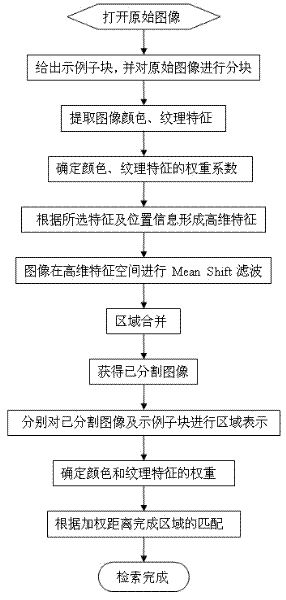
[0051] The technical scheme of the present invention is described in detail below in conjunction with accompanying drawing:

[0052] Remote sensing image retrieval method of the present invention, at first according to the following steps the remote sensing image to be retrieved is segmented:

[0053] Step 1, divide the image into blocks according to the sample sample provided by the user, and extract the Lab color feature and Gabor texture feature of each sub-block;

[0054] Since the Euclidean distance in the Lab color space can more objectively reflect people's perception of color changes in various dimensions in the real world than the color distances in other spaces, the Gabor filter has excellent filter performance and has a similar function to the biological visual system. characteristics, so the present invention's preferred Lab color feature (concrete calculation method can refer to document [Gonzalez R C and Woods RE.2007.Digital Image Processing (2 nd edition).Bei...


PUM


Abstract

The invention relates to a method for segmenting a remote sensing image and belongs to the technical field of processing of the remote sensing image. The method comprises the following steps of: according to color feature, textural feature and the position information of a pixel point, generating a feature vector which serves as an initial input vector; segmenting the remote sensing image by using mean shift filtering; and adaptively determining weights of the color feature and the textural feature by using constructed cluster validity indexes to effectively improve the segmenting accuracy ofthe remote sensing image. The invention also discloses a method for searching the remote sensing image by using the method for segmenting the remote sensing image. The search of the remote sensing image is finished by using a new region representation and matching method. Compared with the prior art, the invention has higher search accuracy, particularly for search of a small target region.

Description

technical field [0001] The invention relates to a remote sensing image retrieval method, in particular to a remote sensing image retrieval method based on precise segmentation of image semantic regions, and belongs to the technical field of remote sensing image processing. Background technique [0002] With the development of satellite remote sensing technology, the rapid query of massive remote sensing images has become an urgent problem to be solved. Content-based remote sensing image retrieval methods make it possible to quickly and accurately query remote sensing images. The content-based remote sensing image retrieval system divides the image into a series of sub-blocks according to a certain block strategy, and completes the image retrieval according to the matching of the visual features of the sub-blocks. However, in content-based remote sensing image retrieval, commonly used blocking strategies divide remote sensing images into a series of fixed-size sub-blocks, wh...

Claims


Application Information

Patent Timeline
Patent Type & Authority Applications(China)
IPC IPC(8): G06T5/00G06F17/30
Inventor 李士进朱佳丽朱跃龙冯钧万定生王继民余宇峰
Owner HOHAI UNIV
Why Eureka
Try Eureka