An Active-Passive Synergistic Inversion Method for Forest Coverage and Effective Leaf Area Index

A technology of forest coverage and area index, applied in the field of inversion, can solve the problem of combining active and passive optical remote sensing data without explaining the physical mechanism, and achieve the effect of reducing uncertainty and improving accuracy

Inactive Publication Date: 2011-12-07
曹春香 +2
View PDF2 Cites 43 Cited by
  • Summary
  • Abstract
  • Description
  • Claims
  • Application Information

AI Technical Summary

Problems solved by technology

At present, most of the fusion researches use the regression model. This method only directly establishes the relationship between the vegetation structure parameters obtained from the lidar data and the vegetation parameters retrieved from the optical multispectral remote sensing data. Illustrates the combination of active and passive optical remote sensing data (Hudak et al., 2006; Lefsky et al., 2005; Popescu et al., 2004; Solberg et al., 2004; Thomas et al., 2006)

Method used


Image

  • An Active-Passive Synergistic Inversion Method for Forest Coverage and Effective Leaf Area Index
  • An Active-Passive Synergistic Inversion Method for Forest Coverage and Effective Leaf Area Index
  • An Active-Passive Synergistic Inversion Method for Forest Coverage and Effective Leaf Area Index

Examples


Embodiment Construction

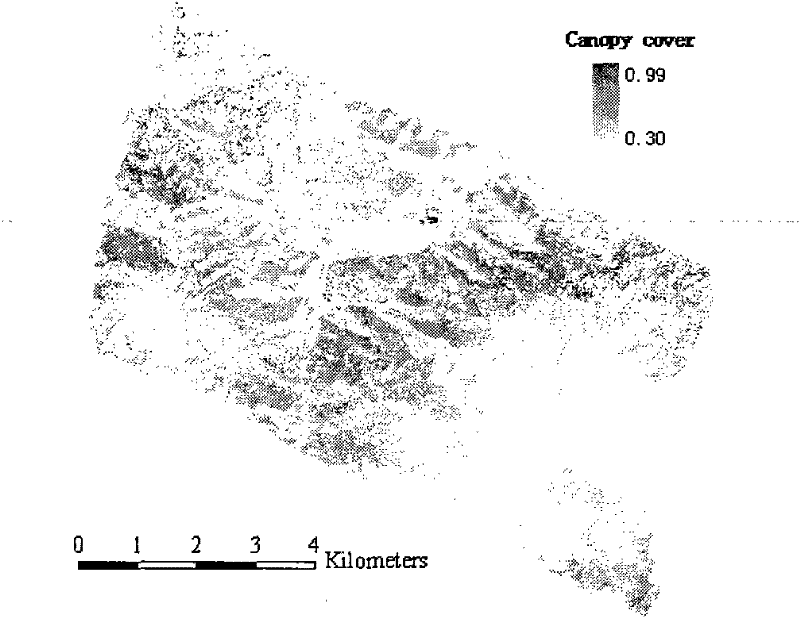
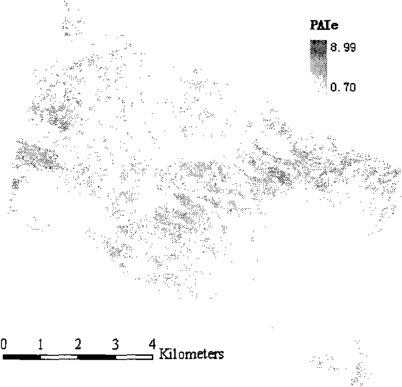
[0018] Inversion of the forest coverage and the effective leaf area index in the Heihe River Basin, Dayekou area, Gansu Province is an example below with the use of laser radar data (LiDAR) and optical remote sensing data (French SPOT-5 satellite data), and the inversion of the present invention is described in detail method.

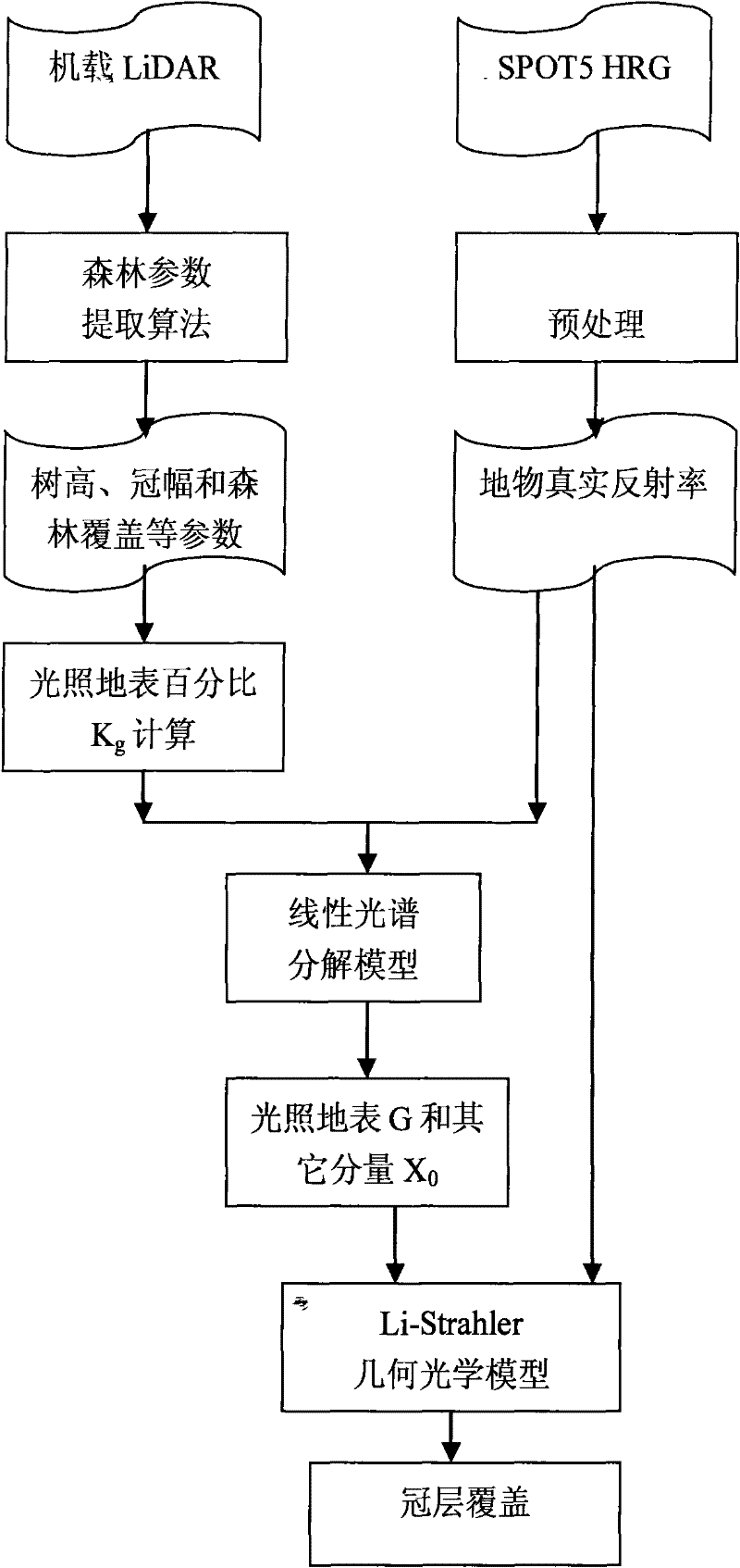
[0019] refer to figure 1 , after extracting forest parameters from the airborne lidar and preprocessing the optical remote sensing data, the collaborative inversion starts.

[0020] The Li-Strahler geometric optics model (Li and Strahler, 1985; 1986; 1992) was developed for the inversion of tree crown size and tree density at the pixel scale on remote sensing images, and has been widely used in the inversion of vegetation structure parameters ( Franklin and Strahler, 1988; Franklin and Turner, 1992; Woodcock et al., 1997; Zeng et al., 2008; Li Xiaowen and Wang Jindi, 1995). The Li-Strahler geometric optics model describes the surface reflection signal...


PUM


Abstract

The invention provides an active-passive collaborative inversion method of forest coverage and effective leaf area index, the method comprising steps: 1) based on the forest parameters in the sample area obtained according to the airborne laser radar, obtained by the Li-Strahler geometrical optics model The percentage of illuminated surface area Kg of each mixed pixel; 2) According to the Kg value of each mixed pixel and the real reflectance of the pixel obtained from the optical remote sensing image, the linear spectral decomposition model is used to obtain the Li-Strahler geometric optics model The reflectance G of the illuminated surface and the average reflectance X0 of other components; 3) The two reflectances G and reflectance X0 obtained in 2) are used to obtain each real pixel on the entire image through the simplified model of Li-Strahler geometric optics The percentage of illuminated surface area Kg', and then get the canopy cover m and effective plant area index PAIe of each pixel. The invention utilizes the combination of the laser radar and the optical remote sensing data to reduce the influence of the mixed pixel and improve the accuracy of the optical remote sensing data inversion of the forest parameters.

Description

technical field [0001] The invention relates to an inversion method, in particular to an active and passive cooperative inversion method for forest coverage and effective leaf area index. Background technique [0002] In the inversion process of remote sensing parameters, mixed pixels will affect the inversion accuracy of surface biophysical parameters. Since the mixed pixel is a combination of different covering features, the mixed pixel first affects the coverage inversion of any kind of ground features in the pixel (Olthof and Fraser, 2007). For example, forest vegetation coverage in forest areas, the traditional remote sensing method for extracting vegetation coverage is the vegetation index method (Dymond et al., 1992). Due to the influence of mixed pixels, this method cannot provide accurate vegetation coverage information. Moreover, the spectrum affecting each mixed pixel is a mixed spectrum of various ground objects. Whether using the empirical regression relationsh...

Claims


Application Information

Patent Timeline
Patent Type & Authority Applications(China)
IPC IPC(8): G01B11/28G01C11/00G01S17/89
Inventor 曹春香
Owner 曹春香
Why Eureka
Try Eureka