SFS (Shape From Shading) three-dimensional reconstruction sparse-DEM (Digital Elevation Model) encrypting method considering surface spectral information

A technology of three-dimensional reconstruction and spectral information, applied in the field of SFS three-dimensional reconstruction encryption sparse DEM, can solve the problems of low accuracy, not considering three-dimensional reconstruction errors, etc., to improve the estimation accuracy, avoid over-smoothing phenomenon, and improve the effect of DEM encryption accuracy

Active Publication Date: 2012-01-18
WUHAN UNIV
View PDF0 Cites 46 Cited by
  • Summary
  • Abstract
  • Description
  • Claims
  • Application Information

AI Technical Summary

Problems solved by technology

[0007] The present invention mainly solves the scientific problems such as the low precision of the light source estimation method of a single grayscale image in the existing SFS technology, and does not consider the error caused by image shadow and vegetation coverage for the three-dimensional reconstruction of a single remote sensing image.

Method used


Image

  • SFS (Shape From Shading) three-dimensional reconstruction sparse-DEM (Digital Elevation Model) encrypting method considering surface spectral information
  • SFS (Shape From Shading) three-dimensional reconstruction sparse-DEM (Digital Elevation Model) encrypting method considering surface spectral information
  • SFS (Shape From Shading) three-dimensional reconstruction sparse-DEM (Digital Elevation Model) encrypting method considering surface spectral information

Examples


Embodiment

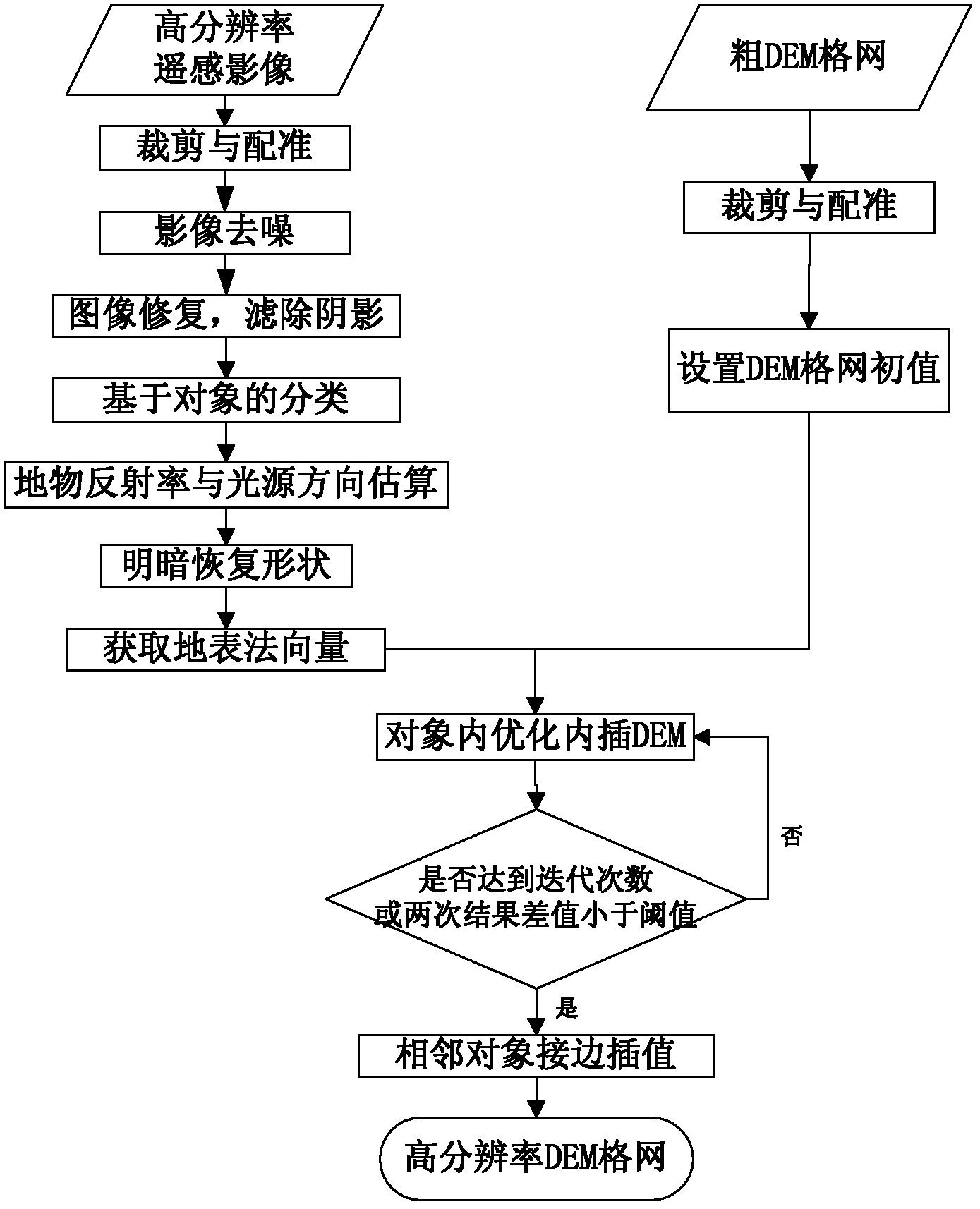
[0128] Such as figure 1 As shown, a SFS three-dimensional reconstruction encryption sparse DEM method that takes into account surface spectral information includes the following steps:

[0129] Step 1, give the relationship between the gradient of the elevation value of the point set on the three-dimensional surface in the x-direction and y-direction and the spectral brightness value at the coordinate point (x, y) in the case of complex land cover, and construct the reflection under different assumptions Map model, and then establish reflection map equations for different ground object coverage types, the data include: coarse resolution DEM grid, high resolution remote sensing images in the same area; reflection map equation is based on the formula:

[0130] I (x,y) =R(p,q)

[0131] and assume:

[0132] 1) The terrain surface is a Lambertian body model;

[0133] 2) The sun light source can be regarded as a parallel projection of a point light source at infinity;

[0134] ...


PUM


Abstract

The invention relates to an SFS (Shape From Shading) three-dimensional reconstruction sparse-DEM (Digital Elevation Model) encrypting method considering surface spectral information. The invention creatively provides a coarse-resolution DEM-grid interpolation-encrypting method by combining multi-spectral remote-sensing images with SFS three-dimensional reconstruction; ground-object spectral information is utilized to estimate the reflectivity of different ground-object types, and the influences of surface-vegetation coverage types on the precision of SFS reconstruction are removed; in the invention, multi-spectral images are utilized to replace full-color images, and the precision of three-dimensional reconstruction is improved by applying the assistance of the ground-object spectral information; the influences of the surface-vegetation coverage types and ground-object shadows on establishing a surface three-dimensional model and image spectral-brightness transforming relation can be effectively inhibited; and relative to a commonly-used DEM interpolation algorithm, the precision is markedly improved, and examples validate that the method can be used for improving the DEM spatial resolution to be two times of original data and finishing large-range rapid DEM establishment based on sparse control points.

Description

technical field [0001] The invention relates to a SFS three-dimensional reconstruction and encryption sparse DEM method, in particular to an SFS three-dimensional reconstruction and encryption sparse DEM method in consideration of surface spectral information. Background technique [0002] Digital Elevation Model (DEM), as basic terrain data, has been widely used in surveying and mapping, remote sensing, military, etc., and is directly affected by the accuracy and resolution of DEM. In addition, emergency response to geological disasters also requires a high-resolution three-dimensional visualization model of the surface, which can assist in the accurate rescue of emergencies and disasters. Therefore, it is of great significance to establish a high-resolution DEM. [0003] The traditional DEM establishment is based on the principle of photogrammetry to obtain stereo image pairs in the same area by the same sensor. However, when high-resolution stereo pairs cannot be obtaine...

Claims


Application Information

Patent Timeline
Patent Type & Authority Applications(China)
IPC IPC(8): G06T17/05
Inventor 孙涛陈喆秦前清陈王丽瞿永新
Owner WUHAN UNIV
Why Eureka
Try Eureka