Method for separating vegetation information from earth surface transmission signals in multi-angle satellite observation signals

A technology for satellite observation and signal transmission. It is used in the reflection/re-radiation of radio waves, measurement devices, and the use of re-radiation. It can solve problems such as poor results and no generalization

Inactive Publication Date: 2012-04-11
REMOTE SENSING APPLIED INST CHINESE ACAD OF SCI
View PDF0 Cites 9 Cited by
  • Summary
  • Abstract
  • Description
  • Claims
  • Application Information

AI Technical Summary

Problems solved by technology

Due to the regional limitations of the experimental site, the obtained vegetation index may have poor effect when applied to other areas, and it is not universally applicable.
On the other hand, the vegetation index obtained through experiments has many empirical factors, but its rationality has not been explained theoretically.

Method used


Image

  • Method for separating vegetation information from earth surface transmission signals in multi-angle satellite observation signals
  • Method for separating vegetation information from earth surface transmission signals in multi-angle satellite observation signals
  • Method for separating vegetation information from earth surface transmission signals in multi-angle satellite observation signals

Examples


Embodiment Construction

[0024] The method of the present invention will be described in detail below with reference to the accompanying drawings.

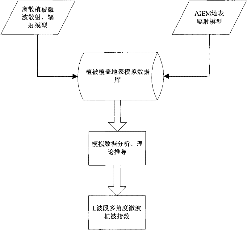
[0025] The invention adopts advanced vegetation discrete model and AIEM (advanced integral model) to simulate the radiation signal of vegetation covering the ground surface, and can obtain the radiation signal of vegetation covering the ground surface under various conditions by adjusting the input parameters of the model. Input the global representative surface parameters, and the data obtained through model technology simulation are more general than the data obtained from several test sites. Vegetation indices developed using this database can be used on a global scale.

[0026] Based on the derivation of theoretical formulas, the development of multi-angle microwave vegetation index has rigorous logic and solid theoretical foundation. It can explain the rationality of the multi-angle microwave vegetation index from the theoretical mechanism.

[0027...


PUM


Abstract

The invention relates to a method for separating vegetation information from earth surface transmission signals in multi-angle satellite observation signals, which comprises the following steps that: 1) by combination of a discrete vegetation model and an AIEM (advanced integral equation model) radiation model, a vegetation covering earth surface radiation model is built; 2) by utilizing the vegetation covering earth surface radiation model, the transmission situations of microwaves at different angles on the earth surface can be simulated under various vegetation coving and earth surface roughness conditions, and a vegetation covering earth surface simulation database is built; and 3) by utilizing the data simulated by the vegetation covering earth surface simulation database, the theoretical derivation is conducted to obtain a method capable of effectively separating the vegetation information from the earth surface transmission signals. The method can also comprise 4) the best combination of multi-angle microwave observation signals can be obtained by the theoretical derivation, and a multi-angle microwave vegetation index is built. Through the method, the vegetation information can be effectively separated from the earth surface information obtained from a satellite, and the method can be accurately used for the monitoring of the satellite for the earth surface vegetation. The multi-angle microwave vegetation index can also be built to meet the application requirements of multi-angle satellites.

Description

technical field [0001] The invention relates to the technical field of earth observation and navigation, and more specifically, relates to a method for separating vegetation information and surface emission signals in multi-angle satellite observation signals for microwave band multi-angle satellites. Background technique [0002] When an object is above absolute zero, it will radiate electromagnetic energy outward. Different objects have different radiated energy intensities due to their own composition, structure, state and other factors, and there will be differences in different bands. The difference in the radiated energy of different ground features can be reflected in the difference in the strength of the output signal of the sensor that receives the energy emitted by the object. This is the basic principle of satellite sensors to observe the surface conditions. [0003] A digital image generated by a satellite is composed of many pixel points, and the value of each ...

Claims


Application Information

Patent Timeline
Patent Type & Authority Applications(China)
IPC IPC(8): G01S13/89G01S7/41
Inventor 施建成杜今阳陈亮
Owner REMOTE SENSING APPLIED INST CHINESE ACAD OF SCI
Why Eureka
Try Eureka