Method for generating line element buffer zone on earth elliposoid based on GIS (geographic information system) component

A technology of ellipsoid and line elements, which is applied in the field of generating buffers of line elements on the earth ellipsoid surface based on GIS components, can solve the problems of inability to meet the requirements of use and the influence of precision map projection deformation.

Inactive Publication Date: 2012-04-11
彭认灿
View PDF0 Cites 11 Cited by
  • Summary
  • Abstract
  • Description
  • Claims
  • Application Information

AI Technical Summary

Problems solved by technology

[0002] At present, the method of establishing the buffer zone of points, lines, planes and composite elements (hereinafter referred to as each element) on the map projection plane is very mature, and has already become the most basic space in various geographic information system (GIS) software. analysis method, and provide users with corresponding application services in the form of GIS desktop software or GIS components (controls), but the accuracy of each element buffer established by this method will inevitably be affected by map projection deformation , so it cannot meet the requirements of marine demarcation and other fields. In response to this problem, relevant scholars have used the ellipsoid geodetic calculation method to eliminate the influence of map projection deformation, and established buffer construction techniques based on the earth ellipsoid ( Peng Zencan, Wang Jiayao. Research on buffer construction technology based on the earth ellipsoid, Journal of Surveying and Mapping, vol31, 2002 (3): 270-273) (document 1); Peng Zencan, Chen Yi, Liu Guohui, etc. MapInfo System The problems and improvement methods of line (area) target buffer construction model, Journal of Wuhan University Information Science Edition, vol 32, 2007 (8): 719-722) (document 2), it is not difficult to find out through the analysis of the above documents , they only briefly give the basic idea of ​​establishing the buffer zone of each element on the earth ellipsoid, but how to use GIS components to establish the buffer zone of each element on the earth ellipsoid is still a technical blank, because point elements can be regarded as It is a special case of line elements or area elements, and area elements and compound elements can be composed of point, line, and area elements. Therefore, it is only necessary to study the buffer generation method of line elements on the earth ellipsoid based on GIS components.

Method used


Image

  • Method for generating line element buffer zone on earth elliposoid based on GIS (geographic information system) component
  • Method for generating line element buffer zone on earth elliposoid based on GIS (geographic information system) component
  • Method for generating line element buffer zone on earth elliposoid based on GIS (geographic information system) component

Examples


Embodiment Construction

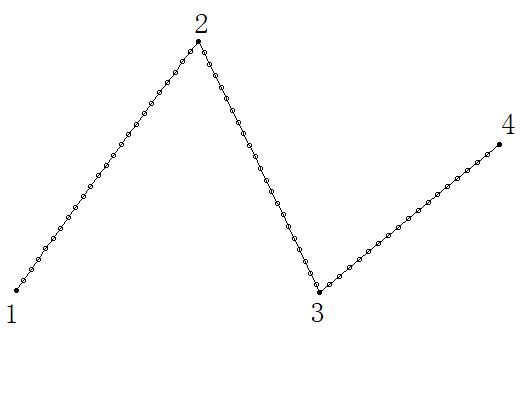
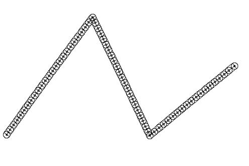
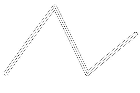
[0019] Such as Figure 1-Figure 5 Shown, the present invention is based on the method for generating the online element buffer on the ellipsoid of the earth based on GIS components, and its specific steps are: a, determine each vertex of the on-line elements on the ellipsoid of the earth after encryption by the geodetic interpolation model, assuming that there is no The coordinates of vertices of the line elements on the earth ellipsoid surface encrypted by the geodetic interpolation model are (b1, l1), (b2, l2), ..., (bm, lm) (units are degrees, the same below), then the geodetic line The coordinates of each vertex of the line elements on the earth ellipsoid after the interpolation model is encrypted are (B1, L1), (B2, L2), ..., (Bn, Ln), where n≥m; b. Calculated by the ellipsoid geodetic calculation formula The geodetic circle with the two ends of the line element on the earth ellipsoid and the encrypted vertices as the center and the buffer distance as the radius is essenti...


PUM


Abstract

The invention discloses a method for generating a line element buffer zone on an earth elliposoid based on a GIS (geographic information system) component. The method comprises the following steps of: a, determining vertexes of line elements on an encrypted earth elliposoid; b, calculating out geodetic circles; c, calculating out geodetic rectangles; and d, adopting a CIS component to perform union set generation on the geodetic circles and rectangles established in the step b and step c, so as to obtain a polygon, namely a line element buffer zone on the earth elliposoid. By the method in the invention, the process for generating a line element buffer zone on the earth elliposoid is greatly simplified, and a convenient and efficient method for generating a line element buffer zone on the earth elliposoid on any map projection plane can be provided for users having GIS secondary development capability, an effective technical means for generating high-precision unilateral and bilateral ocean boundaries can be provided for ocean demarcation, and the method has an important significance on protecting national ocean rights and interests according to laws.

Description

technical field [0001] The invention relates to the field of geographic information system (GIS) and marine delimitation, in particular to a method for generating a line element buffer on an earth ellipsoid based on a GIS component. Background technique [0002] At present, the method of establishing the buffer zone of points, lines, planes and composite elements (hereinafter referred to as each element) on the map projection plane is very mature, and has already become the most basic space in various geographic information system (GIS) software. analysis method, and provide users with corresponding application services in the form of GIS desktop software or GIS components (controls), but the accuracy of each element buffer established by this method will inevitably be affected by map projection deformation , so it cannot meet the requirements of marine demarcation and other fields. In response to this problem, relevant scholars have used the ellipsoid geodetic calculation m...

Claims


Application Information

Patent Timeline
Patent Type & Authority Applications(China)
IPC IPC(8): G09B29/00
Inventor 彭认灿董箭
Owner 彭认灿
Why Eureka
Try Eureka