MBR (Master Boot Record)-based GPS (Global Position System) track map matching method

A technology of map matching and GPS equipment, applied to road network navigators, etc., can solve problems affecting data mining and deep information extraction, affecting positioning accuracy and application requirements, and accuracy is affected by sampling rate, etc., to achieve large data volume , reduce complexity, and reduce errors

Inactive Publication Date: 2012-05-02
HUNAN UNIV OF SCI & TECH
View PDF4 Cites 35 Cited by
  • Summary
  • Abstract
  • Description
  • Claims
  • Application Information

AI Technical Summary

Problems solved by technology

The reason is: GPS signal receiving equipment is usually affected by weather, satellite conditions and the surrounding environment, especially in cities with high-rise buildings, portable GPS positioning equipment still has obvious measurement errors; track data is usually used GPS samples the location, which is also inaccurate, and its accuracy is affected by the sampling rate
The measurement erro

Method used


Image

  • MBR (Master Boot Record)-based GPS (Global Position System) track map matching method
  • MBR (Master Boot Record)-based GPS (Global Position System) track map matching method
  • MBR (Master Boot Record)-based GPS (Global Position System) track map matching method

Examples


Embodiment Construction

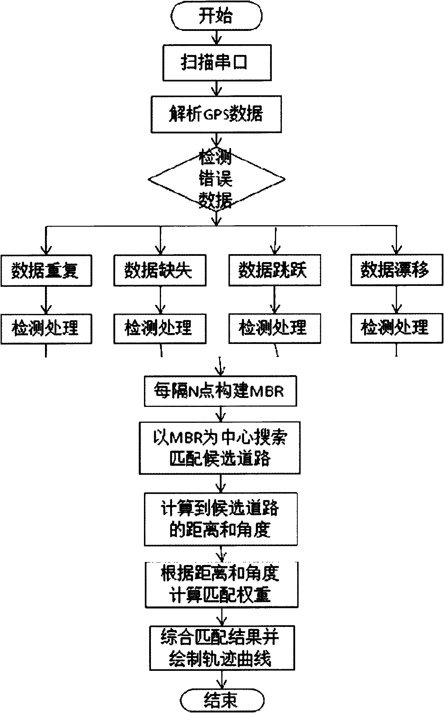
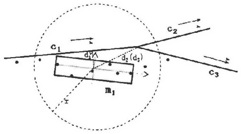
[0034] High-precision, vectorized digital maps can not only provide location information, but also can be used to improve the accuracy of GPS positioning. By matching the trajectory with the map, the maximum possible position of the object relative to the map can be determined, thereby reducing the margin of error and improving positioning accuracy. Improve positioning system performance. Its application is based on two assumptions: 1) the accuracy of the digital map used for map matching is generally required to be less than 15m; 2) the object is moving on the road.

[0035] The implementation of the MBR-based map matching method is mainly divided into the following four steps:

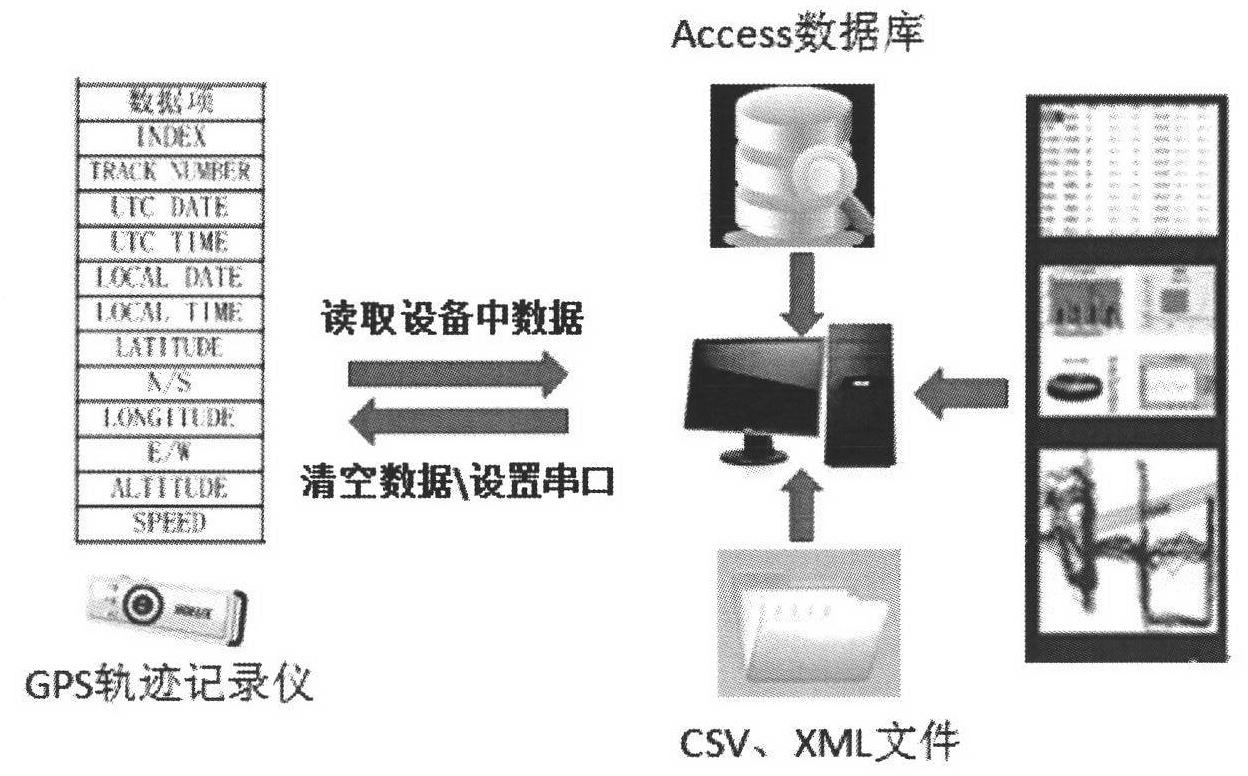
[0036] 1) Connect the portable GPS device with the host computer, read the GPS track csv file corresponding to a certain patrol personnel (patrol area) at a certain time, and obtain information such as the latitude and longitude, elapsed time and passing speed of the coordinate points contained in it...


PUM


Abstract

The invention discloses an MBR (Master Boot Record)-based GPS (Global Position System) track map matching method. Portable GPS equipment is connected with a computer host. The MBR-based GPS track map matching method has the following advantages and active effects: 1, historical information and road network topology information are introduced, and a matching path is judged by using the distance and angle, thus, the matching precision is improved, and errors are reduced; 2, the MBR-based GPS track map matching method is simple and effective, capable of processing larger data volume and good in real-time property, the complexity of matching calculation is lowered, and the time efficiency is increased; 3, the fault tolerance property is better, and incorrect data input is allowed; and 4, error point filtering is realized, and the positioning accuracy is further improved.

Description

Technical field [0001] The present invention relates to new technologies of GPS (Global Positioning System), GIS (Geographic Information System) and computer software, specifically a new MBR-based GPS trajectory map matching method and its example system—the development of security performance assessment and patrol management system . Background technique [0002] At present, the management and supervision of security patrol personnel follow the traditional "management of people" model, and supervise whether the security guards are on duty, whether they are late and leave early without reason, whether they randomly hang around and chat, whether they change the patrol route privately, and whether they follow the time and the number of patrols. The actual operation is easily affected by human factors, so there will inevitably be blanks and loopholes in supervision, empty security patrols and missed inspections in the security patrol management work. In order to prevent the occ...

Claims


Application Information

Patent Timeline
IPC IPC(8): G01C21/30
Inventor 李欢欢
Owner HUNAN UNIV OF SCI & TECH
Why Eureka
Try Eureka