Self-contained navigation method for measurement of earth ultraviolet sensor

An autonomous navigation and sensor technology, applied in directions such as integrated navigators, can solve problems such as large linearization errors, affecting the improvement of navigation accuracy, etc.

Active Publication Date: 2012-06-20
BEIJING INST OF CONTROL ENG
View PDF2 Cites 11 Cited by
  • Summary
  • Abstract
  • Description
  • Claims
  • Application Information

AI Technical Summary

Problems solved by technology

The least squares filtering algorithm is less sensitive to the initial error, and at the same time, it can eliminate outliers, but it needs to use the state transit

Method used


Image

  • Self-contained navigation method for measurement of earth ultraviolet sensor
  • Self-contained navigation method for measurement of earth ultraviolet sensor
  • Self-contained navigation method for measurement of earth ultraviolet sensor

Examples


Embodiment Construction

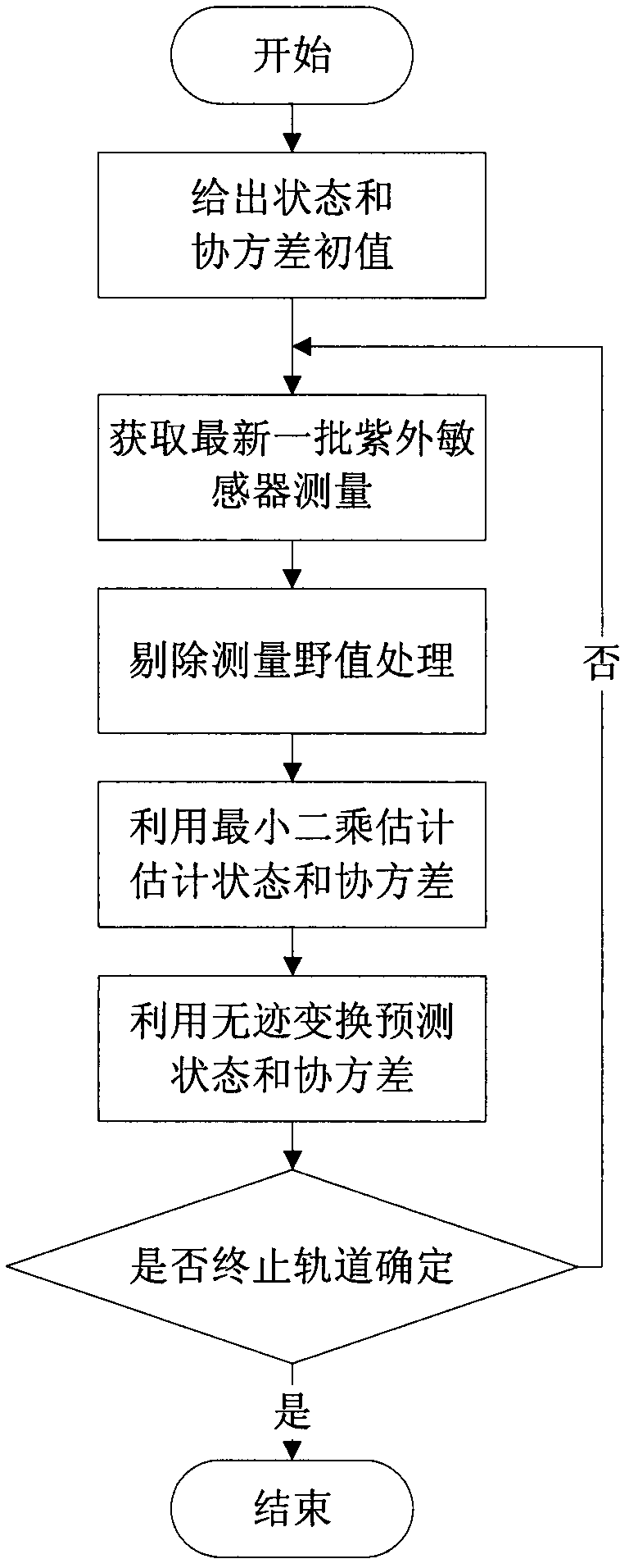
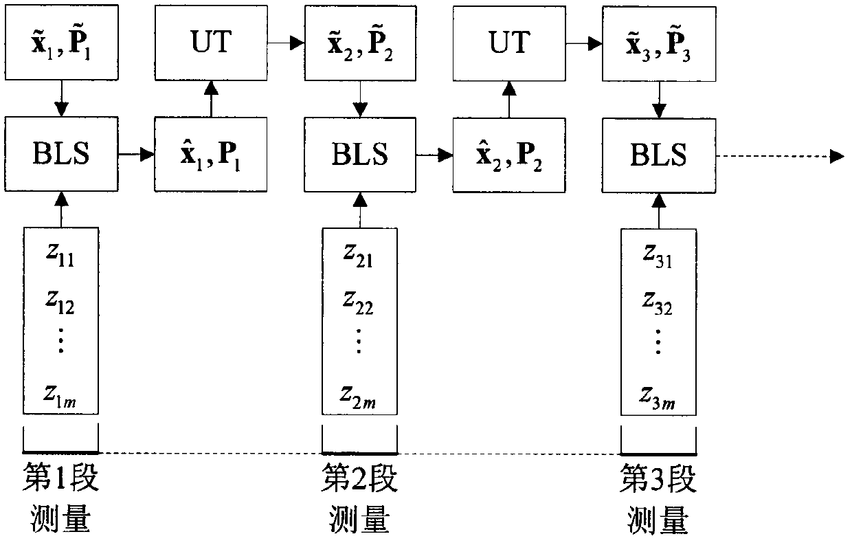
[0040] The earth's ultraviolet sensor can detect the image of the entire earth's edge, and use a large number of edge point information to fit the geometric center of the image, so as to obtain the measurement data of the geocentric vector and the apparent radius of the earth. During the initial orbit determination, the earth’s ultraviolet sensor continuously observes for a period of time, and accumulates the measurements of the geocentric vector and apparent radius corresponding to multiple moments. Firstly, the wild value is eliminated, and then the remaining measurements are used to make the least squares estimation. It is estimated that the satellite is at J2000. 0 position and velocity in the geocentric equatorial coordinate system,. The known system equations and observation equations are as follows

[0041] x · = f ( x ) + w - ...


PUM


Abstract

The invention relates to a self-contained navigation method for measurement of an earth ultraviolet sensor, which comprises the following steps of: initializing: utilizing satellite injection information to supply a state initial value and a covariance initial value outlier of a satellite at a starting moment, accumulating geocentric vector information and earth apparent radius information obtained by the ultraviolet sensor for a specified period of time, and then utilizing an outlier eliminating algorithm to eliminate the outlier in the information; batch processing: performing a least square method on the geocentric vector information and the earth apparent radius information after the outlier is eliminated, and calculating a state estimation Xk and a covariance estimation Pk of the satellite at an ending moment of observation; unscented transformation: utilizing the unscented transformation to realize the time updating of the state and the covariance, obtaining a state forecast X(k+1) and covariance forecast P(k+1) of the satellite at the next ending moment of observation; and recursion: continuously accumulating the geocentric vector information and the earth apparent radius information for a period of time, and repeating the steps and performing continuous recursion and calculation, thereby continuously obtaining the estimation of the state of the satellite. According to the method, the precision and the stability of a navigation system are increased.

Description

technical field [0001] The invention belongs to the field of autonomous navigation of spacecraft, and relates to an autonomous navigation method for earth ultraviolet sensor measurement. Background technique [0002] The earth's ultraviolet sensor can detect the image of the entire edge of the earth, and use a large number of edge point information to fit the geometric center of the image, so as to obtain the measurement data of the geocentric vector and the apparent radius of the earth. At the same time, the ultraviolet sensor can also be sensitive to stellar radiation, providing satellite Attitude information relative to inertial space. Utilizing the rich measurement information of the earth's ultraviolet sensor can completely realize the autonomous navigation of the earth satellite, thereby improving the autonomy and autonomous survivability of the satellite, and at the same time helping to reduce the satellite's dependence on the ground system. [0003] The measurement ...

Claims


Application Information

Patent Timeline
IPC IPC(8): G01C21/24
Inventor 张晓文王大轶黄翔宇张斌
Owner BEIJING INST OF CONTROL ENG
Why Eureka
Try Eureka