
Real-time monitoring and prewarning system for geological disasters

A real-time monitoring and early warning system technology, applied in the direction of alarms, instruments, etc., can solve the problems of low precision of displacement information, high cost, and inability to make comprehensive decision-making and early warning, so as to improve prediction accuracy, intelligent early warning platform, and diversify early warning channels Effect

Active Publication Date: 2013-07-03
NANJING KEBO SPACE INFORMATION TECH
View PDF2 Cites 0 Cited by
  • Summary
  • Abstract
  • Description
  • Claims
  • Application Information

AI Technical Summary

Problems solved by technology

[0002] The current geological disaster early warning system integrates a variety of environmental data measurement components, and uses the communication network to transmit the data and images measured by the measurement components from the on-site monitoring device to the main monitoring device, and then transmit the monitoring information to the responsible unit to speed up the process. Disaster relief work, but the system cannot predict the precipitation in the monitoring area, monitor the quantitative displacement information of the monitoring area or objects in real time, and automatically warn according to the precipitable precipitation and spatial displacement information; at the same time, the system needs to install a large number of sensors, which is costly ; or use rainfall and infrared displacement sensors to transmit to the data center through the wireless network to monitor the actual rainfall intensity, rainfall duration, landslide and subsidence status information and dangerous rock sliding information of landslides and subsidence areas in real time, and comprehensively monitor and evaluate objectively Critical landslide rainfall threshold, landslide evolution process, state, and landslide and collapse grades, but the system cannot predict the amount of precipitation, and the accuracy of displacement information is low, so networked end-user early warning cannot be realized
Fan Yimin et al. (2008) applied GPS technology to early warning of geological disasters in the Three Gorges Reservoir area to provide accurate displacement and deformation information for geological disaster monitoring and early warning; Shu Haichi et al. (2010) improved hardware and software configuration and independent The wireless local area network networking has developed a GPS real-time monitoring system for geological disaster deformation, which has the characteristics of all-weather, automation, and application in complex outdoor environments, and can well ensure the accuracy of monitoring, but does not consider geological disasters such as precipitation and landslides. The correlation between them cannot make comprehensive decisions and early warnings based on information such as displacement information and precipitation.
[0003] The above-mentioned technologies are the latest technologies for geological disaster monitoring and early warning technology, but there are some problems. The various technologies are relatively independent, and the response relationship between the spatial information and the meteorological information in the geological disaster area cannot be considered comprehensively, and it cannot be quickly and directly provided to the geological disaster area. End users provide instant warning information

Method used


Image

  • Real-time monitoring and prewarning system for geological disasters
  • Real-time monitoring and prewarning system for geological disasters
  • Real-time monitoring and prewarning system for geological disasters

Examples


Embodiment

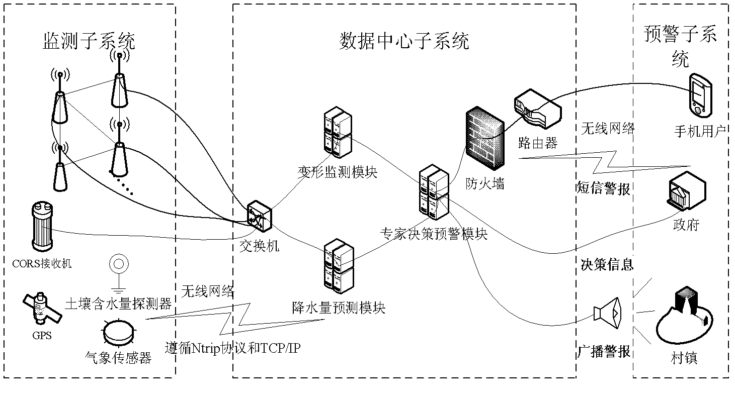
[0038] The monitoring area in the present embodiment is a landslide body, and this geological disaster real-time monitoring and early warning system is mainly implemented by four parts:

[0039] first part:

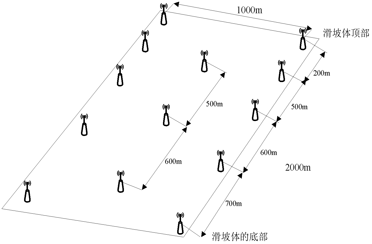
[0040] Construct the monitoring subsystem, select a monitoring area, the monitoring area is a landslide body, the height from the top of the slope to the slope is 2km, and the distribution of monitoring points is as follows: image 3 As shown, because the weight-bearing part of the landslide is at the top, and its upper half is more harmful than the lower half, the landslide mainly monitors its vertical displacement, especially the top, so the monitoring points are mainly vertical The closer the distance to the top, the shorter the distance between the monitoring points. In order to monitor and analyze the horizontal displacement of the entire landslide, it is necessary to arrange the monitoring points in the lateral direction. In addition, the characteristic parts in the...


PUM


Abstract

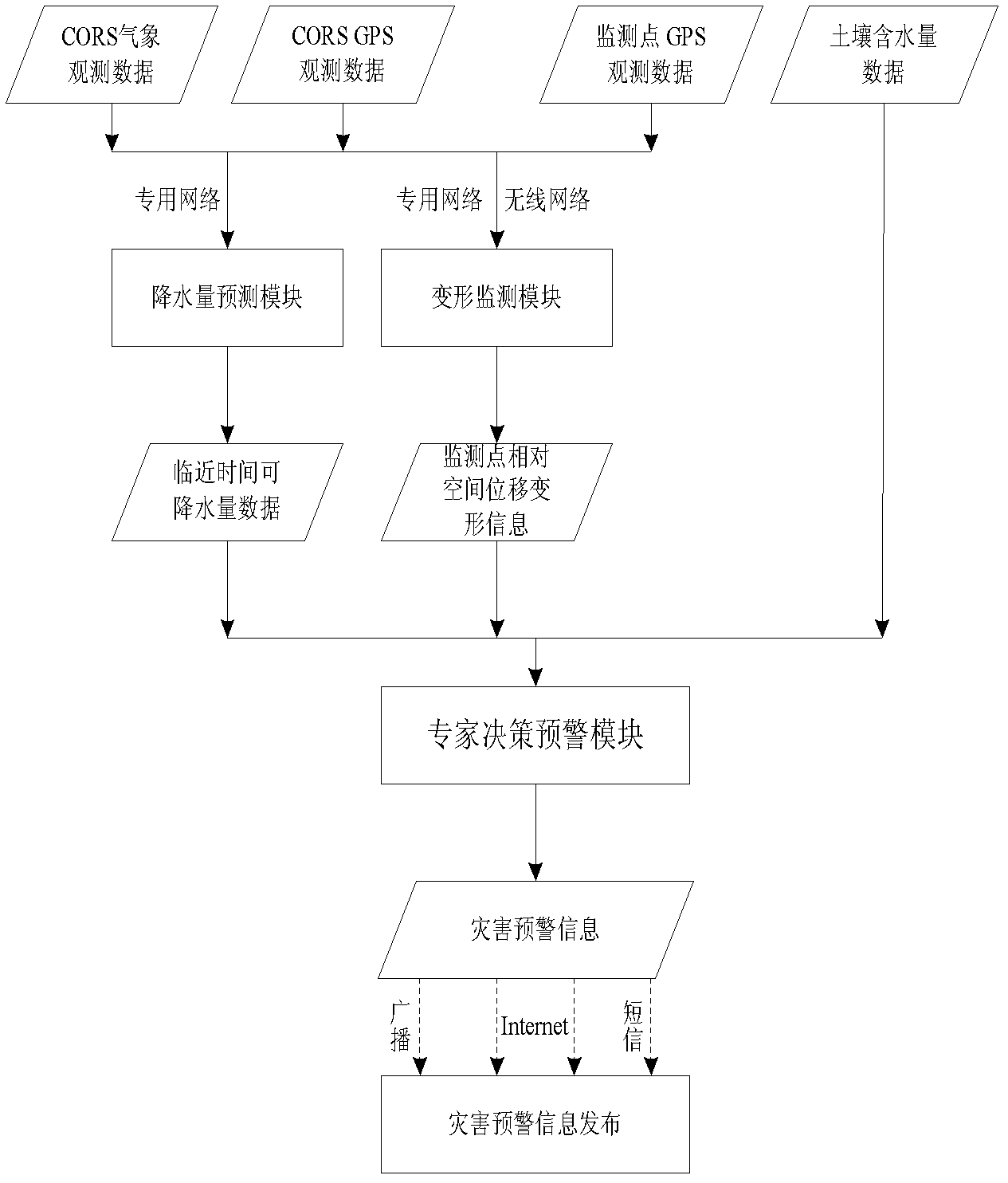
The invention discloses a real-time monitoring and early warning system for geological disasters, which comprises a system monitoring subsystem, a data center subsystem, a prewarning subsystem and a communication network, wherein, the system monitoring subsystem comprises at least one monitoring station and at least one continuous operation reference station and is used for acquiring observation data of the monitoring stations and continuous operation reference stations and the data of the periphery of the stations; the data center subsystem is used for receiving the observation data of the monitoring subsystem, obtaining the prewarning data through analyzing and processing the observation data, and giving out prewarning signals according to the prewarning data; the prewarning subsystem receives the prewarning signals sent by the data center subsystem and performs the prewarning process; and the communication network is used for providing communication for the monitoring subsystem, the data center subsystem and the prewarning subsystem, thereby realizing the real-time monitoring and prewarning function.

Description

technical field [0001] The invention relates to a disaster early warning system, in particular to a geological disaster real-time monitoring and early warning system. Background technique [0002] The current geological disaster early warning system integrates a variety of environmental data measurement components, and uses the communication network to transmit the data and images measured by the measurement components from the on-site monitoring device to the main monitoring device, and then transmit the monitoring information to the responsible unit to speed up the process. Disaster relief work, but the system cannot predict the precipitation in the monitoring area, monitor the quantitative displacement information of the monitoring area or objects in real time, and automatically warn according to the precipitable precipitation and spatial displacement information; at the same time, the system needs to install a large number of sensors, which is costly ; or use rainfall an...

Claims


Application Information

Patent Timeline
Patent Type & Authority Patents(China)
IPC IPC(8): G08B21/10G08B25/00
Inventor 柯福阳
Owner NANJING KEBO SPACE INFORMATION TECH
Learn More