Intelligent navigation method and equipment based on augmented reality technology

An intelligent navigation and augmented reality technology, applied in the field of navigation, can solve problems such as unfavorable driving safety, increase, and inability to perform real-time updates, and achieve the effect of improving navigation accuracy and ease of use

Inactive Publication Date: 2012-06-27
杨志远
View PDF4 Cites 54 Cited by
  • Summary
  • Abstract
  • Description
  • Claims
  • Application Information

AI Technical Summary

Problems solved by technology

[0003] The existing navigation maps basically use two-dimensional electronic maps. For some users, the two-dimensional electronic map is quite different from the real scene. Users may ignore the actual road conditions while paying attention to the electronic map. For car users , the possibility of danger will increase if you don’t look at the road conditions for a long time, which is not conducive to driving safety
[0004] Some existing three-dimensional navigation maps are pre-collected three-dimensional images of various streets and intersections. During navigatio

Method used


Image

  • Intelligent navigation method and equipment based on augmented reality technology
  • Intelligent navigation method and equipment based on augmented reality technology
  • Intelligent navigation method and equipment based on augmented reality technology

Examples


Embodiment Construction

[0033] Specific embodiments of the present invention will be described below in conjunction with the accompanying drawings.

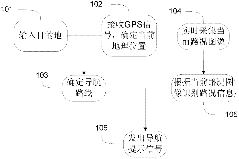
[0034] figure 1 Shown is the flow chart of the intelligent navigation method based on augmented reality technology provided by the present invention, and the navigation method includes the following steps:

[0035] 101. The user inputs a destination. Specifically, the user can input the destination through the navigation device, or choose to connect to the network side service center to set the destination through the network. The network may be a wireless communication network or the Internet. For example, the user sets the destination remotely through the network-side call center by dialing the network-side call center.

[0036] When the user inputs the destination through the navigation device, the destination may be input by inputting text information, or the destination may be input by voice information.

[0037] 102. Receive GPS satellite sign...


PUM


Abstract

The invention discloses an intelligent navigation method and intelligent navigation equipment based on an augmented reality technology. According to the invention, road condition images are collected by using an image collecting apparatus; the collected images are processed; various road condition characteristics are abstracted; according to the abstracted road condition characteristics and a predetermined navigation path, real-time navigation prompting information is transmitted according to actual situations. The navigation prompting information is transmitted on a basis that a current road condition is determined. Therefore, the information is more realistic, and satisfies user requirements.

Description

technical field [0001] The present invention relates to the field of navigation, and in particular to an intelligent navigation method and device based on augmented reality technology. Background technique [0002] All the currently widely used navigation devices have pre-set maps and GPS receivers. The GPS information is received by the GPS receiver to determine the user's current geographic location. A navigation route to the destination is planned on the computer, and the navigation prompt information is displayed through the display device. [0003] The existing navigation maps basically use two-dimensional electronic maps. For some users, the two-dimensional electronic map is quite different from the real scene. Users may ignore the actual road conditions while paying attention to the electronic map. For car users , the possibility of danger will increase if you don’t look at the road conditions for a long time, which is not conducive to driving safety. [0004] Some ...

Claims


Application Information

Patent Timeline
IPC IPC(8): G01C21/26
Inventor 杨志远
Owner 杨志远
Why Eureka
Try Eureka