Real-time photogrammetry processing system of airborne aerial image

A photogrammetry and processing system technology, applied in photogrammetry/video surveying, measuring devices, mapping and navigation, etc., can solve the problems of high power consumption, large volume, and complex data processing process.

Inactive Publication Date: 2012-07-11
WUHAN UNIV
View PDF4 Cites 10 Cited by
  • Summary
  • Abstract
  • Description
  • Claims
  • Application Information

AI Technical Summary

Problems solved by technology

However, the new-generation photogrammetry system based on the cluster computer is not suitable for airborne real-time processing due to its large size, high power consumption, multiple data accesses, and complicated data processing.

Method used


Image

  • Real-time photogrammetry processing system of airborne aerial image
  • Real-time photogrammetry processing system of airborne aerial image
  • Real-time photogrammetry processing system of airborne aerial image

Examples


specific Embodiment approach

[0020] The technical solution of the present invention will be described in detail below in conjunction with the drawings and embodiments.

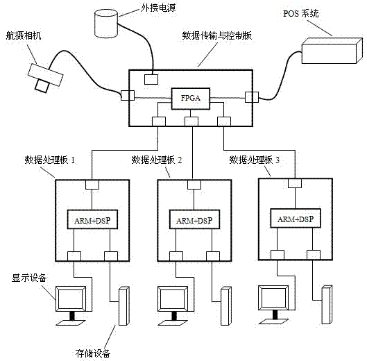
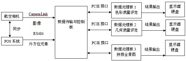
[0021] see figure 1 The system for providing real-time photogrammetry processing of airborne aerial images in the embodiment of the present invention includes data transmission and control boards, data processing boards and other boards. During specific implementation, peripheral hardware such as external power supplies, storage devices, and display devices can also be equipped. The data processing board used for image color quality evaluation, the data processing board used for image geometric quality evaluation, and the data processing board used for panorama stitching are respectively recorded as data processing board 1, data processing board 2, and data processing board in the figure 3. see figure 2 , while the aerial camera is shooting images, the POS system synchronously generates the data of the outer orientation elements of the...


PUM


Abstract

The invention discloses a real-time photogrammetry processing system of an airborne aerial image. The real-time photogrammetry processing system comprises a data transmission and control board and three data processing boards, wherein a camera and a POS (Point Of Sale) system are used for respectively obtaining data; the data transmission and control board is used for receiving the data obtained by the camera and the POS system and respectively sending the received data to the three data processing boards; the three data processing boards are used for respectively carrying out image colour quality evaluation, image geometric quality evaluation and panoramic image mosaic processing; and a processing result is stored in a hard disk and displayed on a display. With regard to airborne photogrammetry real-time processing, the real-time photogrammetry processing system disclosed by the invention has a clear goal and a more fixed data processing content; the airborne photogrammetry real-timeprocessing is realized by adopting an embedded system orienting to special application; the real-time photogrammetry processing system has strong advantages, such as small system volume, low power consumption and high processing speed; and the real-time photogrammetry processing system is convenient to install on a machine.

Description

technical field [0001] The invention relates to the field of photogrammetry and remote sensing and embedded computer technology, in particular to an airborne aerial image real-time photogrammetry processing system. Background technique [0002] As one of the main means of geospatial information, photogrammetry has developed to the current new generation of cluster digital photogrammetry system, and the processing efficiency has been greatly improved, but it still lags behind the requirements of social and economic development for the real-timeness of spatial data acquisition. Especially when disasters and emergencies occur, "time is life, and time is property". At this time, the requirements for geospatial data are very urgent for the development of various tasks. I hope that the three-dimensional space can be obtained wherever the plane flies. Data, the aircraft can use these data to guide the development of related work when it lands. At present, even the fastest new-gener...

Claims


Application Information

Patent Timeline
Patent Type & Authority Applications(China)
IPC IPC(8): G01C11/00G01C11/30
Inventor 郑顺义桂力王晓南马电罗迪张剑哲徐轩
Owner WUHAN UNIV
Why Eureka
Try Eureka