Method for processing errors generated by point cloud registration in process of surface reconstruction of measuring object by using ground laser scanning technique

A technology for ground laser scanning and measuring objects, which is applied in image data processing, instruments, calculations, etc., can solve the problems of large point errors at the end points of the model, accurate registration of point clouds, and 3D modeling errors and errors.

Inactive Publication Date: 2012-07-25
ANHUI UNIVERSITY OF ARCHITECTURE
View PDF0 Cites 17 Cited by
  • Summary
  • Abstract
  • Description
  • Claims
  • Application Information

AI Technical Summary

Problems solved by technology

The accumulation of this kind of error will make the point error at the end point of the model larger, which will bring errors or even errors to the precise registration of point clouds and subsequent 3D modeling.

Method used


Image

  • Method for processing errors generated by point cloud registration in process of surface reconstruction of measuring object by using ground laser scanning technique
  • Method for processing errors generated by point cloud registration in process of surface reconstruction of measuring object by using ground laser scanning technique
  • Method for processing errors generated by point cloud registration in process of surface reconstruction of measuring object by using ground laser scanning technique

Examples


Embodiment Construction

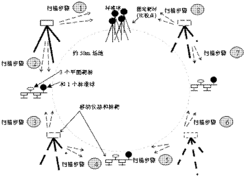
[0055] A method for processing point cloud registration errors when using terrestrial laser scanning technology to reconstruct the surface of a measurement object, specifically comprising the following steps:

[0056] (1), using the least squares adjustment method to solve 6 spatial similarity transformation parameters ω, κ, ΔX, ΔY, ΔZ, namely three angle rotation parameters: ω, κ and three translation parameters: ΔX, ΔY, ΔZ, and determine the mathematical model of point cloud registration error propagation as follows:

[0057]

[0058] Wherein, (X, Y, Z) and (x, y, z) are respectively the coordinates of the same point in different scanner coordinate systems, and R is a rotation matrix;

[0059] (2), expand formula (1) using Taylor series, and take the first-order term, then we have

[0060]

[0061]

[0062] in:

[0063] From this the error equation can be obtained:

[0064]

[0065]

[0066] Let K be V in formula (2) (k) The coefficient matrix, L=F-F...


PUM


Abstract

The invention discloses a point cloud registration error processing method, namely, a method for processing errors generated by point cloud registration in the process of surface reconstruction of an object by using a ground laser scanning technique. The method comprises the following steps: carrying out image matching according to a photogrammetric image matching principle, and determining a mathematical model of error propagation of multistation point cloud registrations; obtaining a coefficient matrix according to error equations; calculating the variance of six parameters, the variance of model points and the variance of unit weight in a rotation matrix; according to a co-factor matrix of the six parameters, obtaining an observed-value co-factor matrix and a variance matrix of estimated observed values, and obtaining a diagonal variance matrix consisting of the six parameters and the model points; according to a law of covariance propagation and a coefficient matrix of error equations, obtaining error propagation models of point cloud registrations under two different scanning coordinate systems; and determining the number of sequential registrations, calculating a parameter error equation coefficient matrix of each registration, and multiplying the coefficient matrixes by a variance obtained after the previous registration is completed, so that an error propagation model of multistation registrations can be obtained.

Description

technical field [0001] The invention relates to the fields of surveying and mapping science and technology, reverse engineering, and digital protection of ancient buildings, in particular to a method for processing point cloud registration errors when using ground laser scanning technology to reconstruct object surfaces. Background technique [0002] At present, terrestrial 3D laser scanning technology is becoming more and more mature, and terrestrial laser scanner (TLS) is also gradually commercialized. Its application field and scope develop in depth and breadth with the deepening of research. It has extensive application value in scientific and engineering fields such as digital cultural relics and historical buildings, digital museums, digital archaeology, topographic surveying, virtual reality, digital cities, urban planning, digital entertainment, film and television special effects production, and reverse engineering. As a brand-new measurement technology, ground thre...

Claims


Application Information

Patent Timeline
Patent Type & Authority Applications(China)
IPC IPC(8): G06T7/00
Inventor 施贵刚刘仁义黄显怀左光之金乃玲徐雪芳张绪能高旭光左伟
Owner ANHUI UNIVERSITY OF ARCHITECTURE
Why Eureka
Try Eureka