

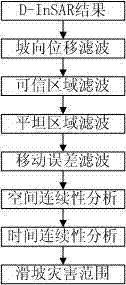
Landslide dynamic identifying and monitoring technology based on synthetic aperture radar differential interferometry (D-InSAR)
A dynamic identification and differential technology, applied in measurement devices, radio wave measurement systems, radio wave reflection/re-radiation, etc. Dynamic monitoring and other issues
- Summary
- Abstract
- Description
- Claims
- Application Information
AI Technical Summary
Problems solved by technology
Method used
Image


Examples
Embodiment Construction
[0025] Some computing methods involved in the present invention.
[0026] 1. Acquisition of aspect displacement.
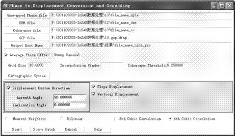
[0027] The first method is to select Slope Displacement in the dialog box of the last step of D-InSAR three-track difference in SARscape (synthetic aperture radar data processing software), such as figure 1 shown.
[0028] The second method is to calculate through the formula, the formula is as follows.
[0029] Among them: A=Slope angle, B=Zenith incident angle, C=Azimuth incident azimuth, D=Aspect slope azimuth, E=SightDisplacement line-of-sight displacement.
[0030] 2. The formula for solving the angle between the satellite line of sight and the slope normal is:
[0031] Among them: azimuthAngle is the azimuth angle of the satellite flight, θ is the angle between the vertical line of the satellite surface, δ is the azimuth angle of the ground surface, and α is the slope angle of the ground surface.
[0032] In order to enable those skilled in the art to be...
PUM
 Abstract
Description
Claims
Application Information