Remote sensing earth surface temperature up-scaling method and system

A technology of surface temperature and scale, which is applied in the field of satellite remote sensing, can solve the problems of average error and failure to consider the surface temperature, etc., and achieve the effect of reducing error and realizing error correction

Active Publication Date: 2012-09-12
BEIJING RES CENT FOR INFORMATION TECH & AGRI
View PDF4 Cites 14 Cited by
  • Summary
  • Abstract
  • Description
  • Claims
  • Application Information

AI Technical Summary

Problems solved by technology

In the existing surface temperature upscaling methods, the average value of the first-scale surface temperature is used to replace the second-scale surface temperature after upscaling. This method does not take into account that the surface temperature is a physical quantity that has nothing to do with the unit area. Calculating the average will inevitably bring about a large error

Method used


Image

  • Remote sensing earth surface temperature up-scaling method and system
  • Remote sensing earth surface temperature up-scaling method and system
  • Remote sensing earth surface temperature up-scaling method and system

Examples


Embodiment Construction

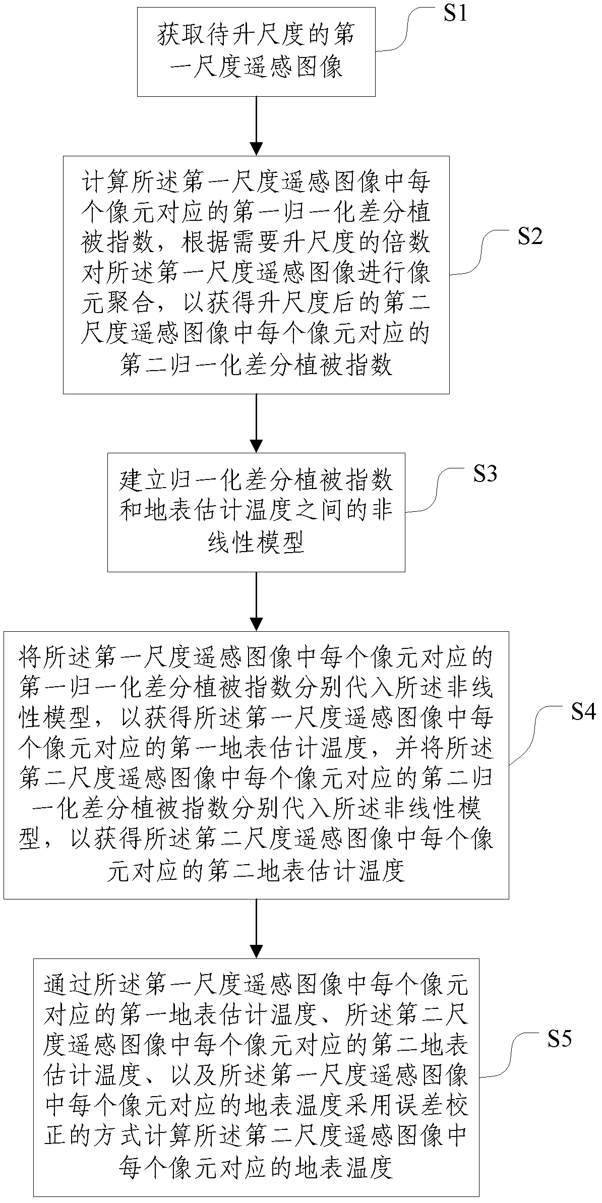
[0039] The specific implementation manners of the present invention will be further described in detail below in conjunction with the accompanying drawings and embodiments. The following examples are used to illustrate the present invention, but are not intended to limit the scope of the present invention.

[0040] figure 1 It is a flow chart of the remote sensing surface temperature upscaling method according to an embodiment of the present invention; refer to figure 1 , the method of this embodiment includes the following steps:

[0041] S1: Obtain the first-scale remote sensing image to be scaled up;

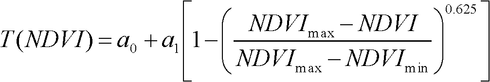
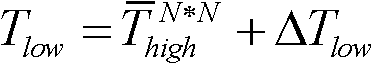
[0042] S2: Calculate the first normalized difference vegetation index NDVI corresponding to each pixel in the first-scale remote sensing image high , perform pixel aggregation on the first-scale remote sensing image according to the required upscaling multiple to obtain the second normalized differential vegetation index NDVI corresponding to each pixel in the up-scaled se...


PUM


Abstract

The invention discloses a remote sensing earth surface temperature up-scaling method and a system, and relates to the technical field of satellite remote sensing. According to the invention, a first scale remote sensing image is fully used for calculating a normalized difference vegetation index sensitive to the earth surface temperature, by building a non-linear model between the normalized difference vegetation index and the earth surface temperature and using earth surface evaluated temperature difference of the normalized difference vegetation index under two scales, error correction to up-scaled earth surface temperature is achieved, and errors caused during up-scaling of the earth surface temperature are reduced.

Description

technical field [0001] The invention relates to the technical field of satellite remote sensing, in particular to a method and system for remote sensing surface temperature upscaling. Background technique [0002] Surface temperature is an important indicator of land surface energy balance and climate change. It is a key parameter of surface physical processes at regional and global scales. It is widely used in many research fields such as meteorology, hydrology, geology, ecology, urban environment, and disaster monitoring. need. At present, in the process of carrying out global change research, how to use the first-scale (that is, with higher resolution) surface temperature to obtain the second-scale (that is, with lower resolution) surface temperature has become the key. In the existing surface temperature upscaling methods, the average value of the first-scale surface temperature is used to replace the second-scale surface temperature after upscaling. This method does no...

Claims


Application Information

Patent Timeline
IPC IPC(8): G01K3/02
Inventor 赵春江杨贵军黄文江王纪华冯海宽李存军宋晓宇徐新刚杨小冬顾晓鹤杨浩陈红
Owner BEIJING RES CENT FOR INFORMATION TECH & AGRI
Why Eureka
Try Eureka