Three-dimensional space index method aiming at massive laser radar point cloud models

A three-dimensional space, point cloud model technology, applied in special data processing applications, instruments, electrical digital data processing and other directions, can solve problems such as the lack of efficient retrieval of massive spatial data and the reduction of spatial index retrieval efficiency.

Inactive Publication Date: 2012-09-19
北京建筑工程学院
View PDF3 Cites 41 Cited by
  • Summary
  • Abstract
  • Description
  • Claims
  • Application Information

AI Technical Summary

Problems solved by technology

However, for massive point cloud model data, the 3D K-D tree needs to be indexed to a single 3D point or a small number of 3D point sets, and its tree depth often exceeds 10 layers, or even reac

Method used


Image

  • Three-dimensional space index method aiming at massive laser radar point cloud models
  • Three-dimensional space index method aiming at massive laser radar point cloud models

Examples


Embodiment Construction

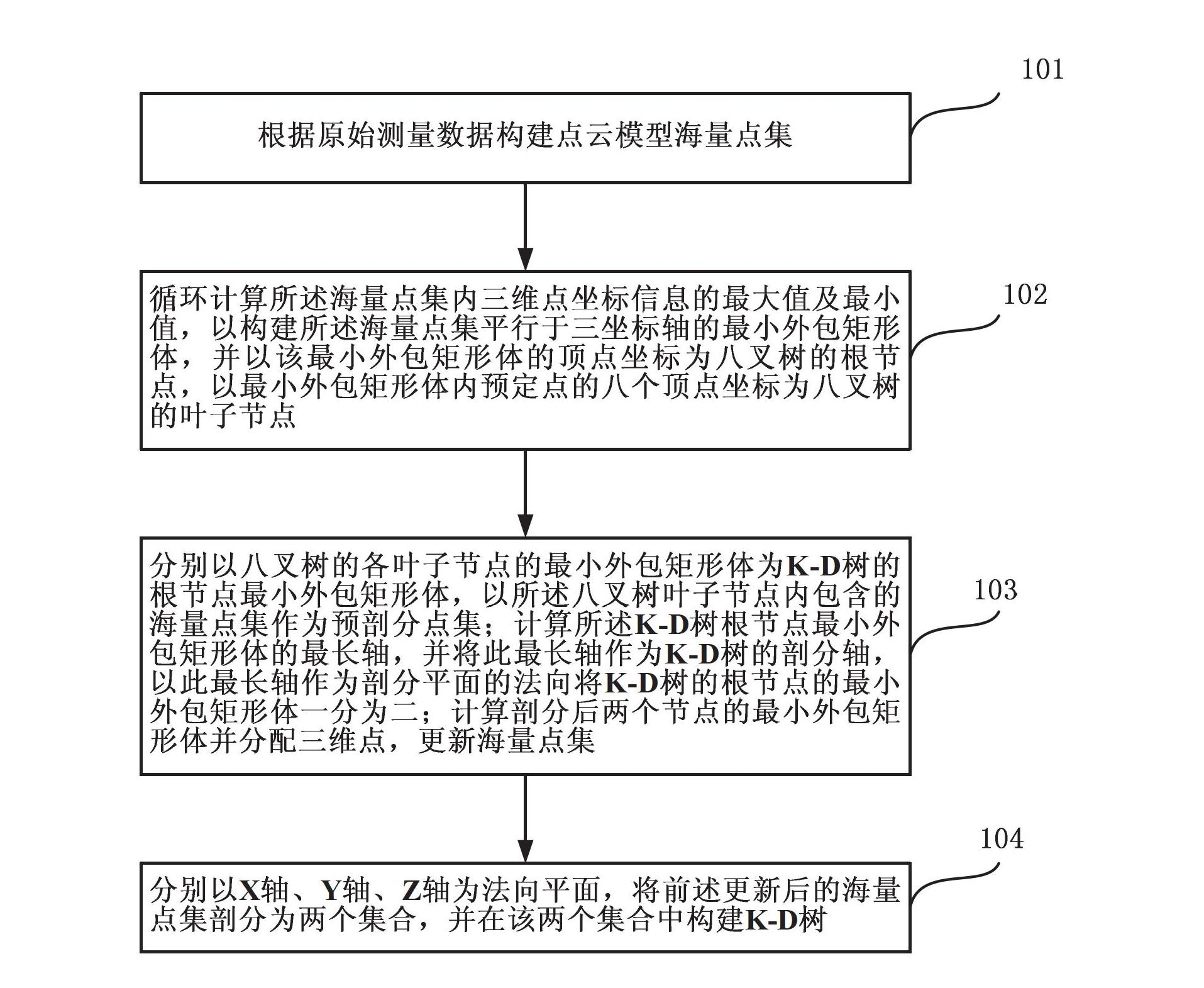
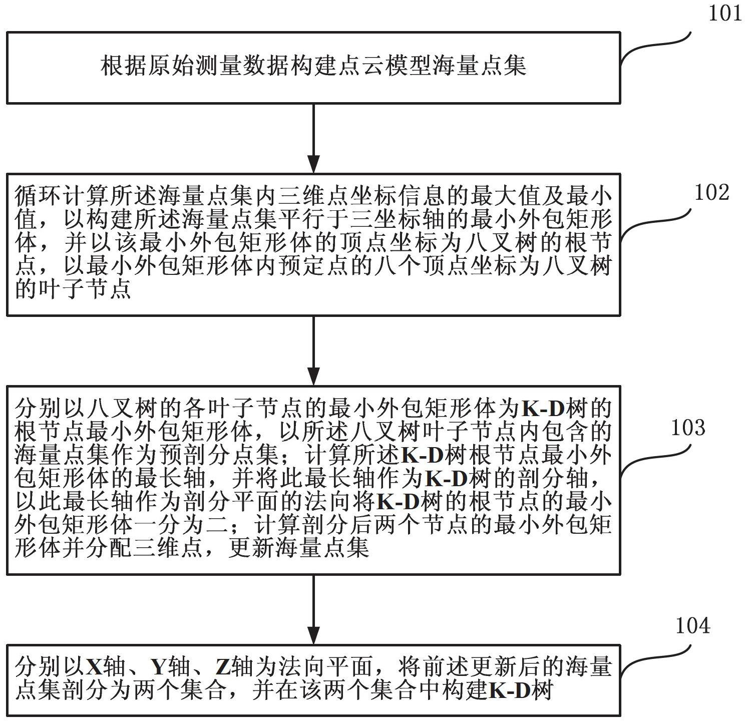
[0018] The present invention will be further described in detail below in conjunction with the accompanying drawings, so that those skilled in the art can implement it with reference to the description.

[0019] The three-dimensional spatial index method for massive laser radar point cloud models described in the present invention combines the respective index characteristics of the octree spatial index, the three-dimensional K-D tree spatial index and the three-dimensional R-tree spatial index, and indexes in a manner of first integration and then mixing Massive fine point cloud model data, in the three-dimensional space indexing method described in the present invention, need to involve five kinds of data objects, are respectively three-dimensional point data, vertex data, minimum outsourcing rectangular body data, octree node data and K-D tree node data.

[0020] Among them, the three-dimensional point data includes x, y, z three-dimensional coordinate value attribute infor...


PUM


Abstract

The invention discloses a three-dimensional space index method aiming at massive laser radar point cloud models. Aiming at characteristics of massive data and high spatial resolution of point cloud models, the method indexes data to a single three-dimensional space point by adopting a multi-level hybrid index strategy; aiming at an integrity characteristic of point cloud models, the method continuously subdivides massive cloud points from a minimum bounding rectangle (MBB) of an overall point cloud model by adopting a cotree index, and three-dimensional points in cotree index nodes are distributed uniformly in space; and aiming at a scattered characteristic and the data post-processing requirement of large-scale point cloud models, the method indexes a single three-dimensional space point by adopting a three-dimensional K-D tree, and the quick inquiry and processing of a single point coordinate and the attribute data of the single point coordinate can be achieved. On the basis of above integrated space index construction, the method adopts a three-dimensional R tree to manage the MBBs of a plurality of point cloud models in three-dimensional scenes, and a multi-level hybrid space index mode is formed finally.

Description

technical field [0001] The invention relates to a three-dimensional space indexing method, in particular to a three-dimensional space indexing method for massive laser radar point cloud models. Background technique [0002] The point cloud model is a three-dimensional spatial data model based on scattered point sets, which itself contains various characteristics of the point cloud. [0003] Generally speaking, the point cloud model is a complete target point cloud model obtained by processing the multi-view scanning point cloud through deduplication, multi-temporal registration and fusion. It is the primary product obtained after processing multiple single-site clouds. The point cloud model has the characteristics of large amount of data (massiveness), fine data expression (high spatial resolution), relatively balanced spatial distribution (integrity), and no topological relationship between spatial three-dimensional points (scattered). [0004] Both K-D tree and Octree are...

Claims


Application Information

Patent Timeline
IPC IPC(8): G06F17/30
Inventor 王晏民郭明
Owner 北京建筑工程学院
Why Eureka
Try Eureka