Method for determining groundwater occurrence

A determination method, groundwater technology, applied in the direction of sound wave re-radiation, electrical/magnetic exploration, geophysical measurement, etc., can solve the problem of damage to the Quaternary stratum structure, stratum collapse, and the inability to obtain the distribution of water in the Quaternary stratum and other problems to achieve the effect of accurate data

Active Publication Date: 2013-01-09
CHINA SHENHUA ENERGY CO LTD +1
View PDF3 Cites 10 Cited by
  • Summary
  • Abstract
  • Description
  • Claims
  • Application Information

AI Technical Summary

Problems solved by technology

[0005] Due to coal mining, the strata will collapse, destroy the Quaternary strata structure, and cause the loss and change of surface water. If the

Method used


Image

  • Method for determining groundwater occurrence
  • Method for determining groundwater occurrence
  • Method for determining groundwater occurrence

Examples


Embodiment Construction

[0051] Hereinafter, the present invention will be described in detail with reference to the drawings and specific embodiments.

[0052] The invention provides a method for determining the distribution of groundwater, which can obtain the distribution of water in the Quaternary formation. A specific embodiment is given below for detailed description.

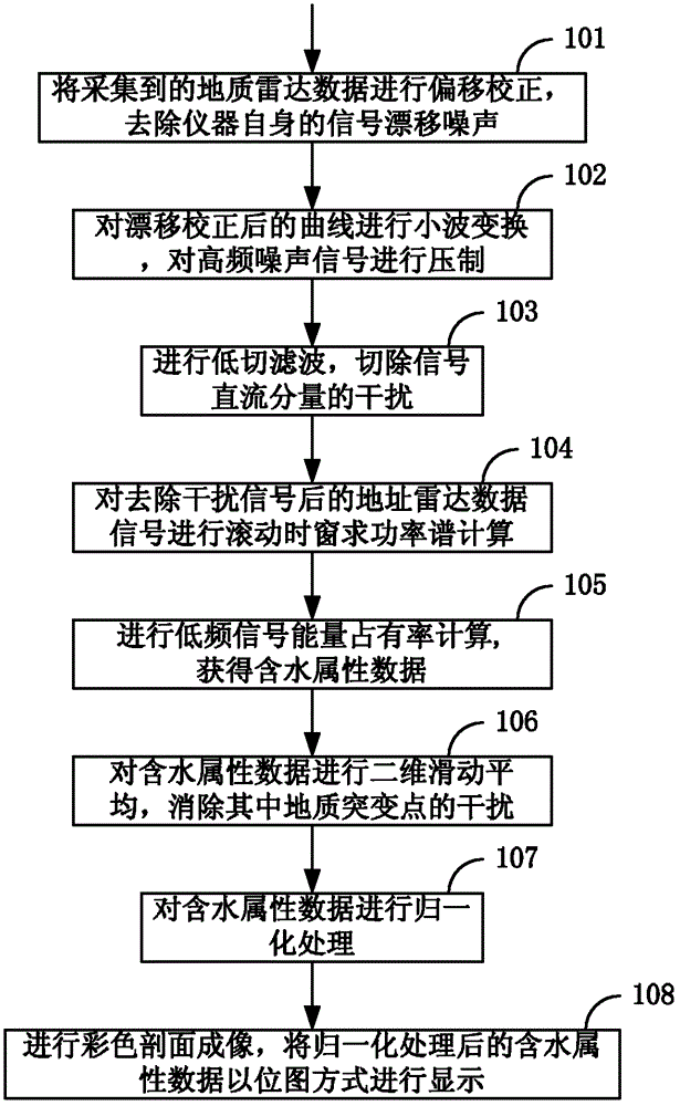
[0053] Such as figure 1 As shown, the method for determining the distribution of groundwater in a preferred embodiment of the present invention adopts geological radar to collect data, which specifically includes the following steps:

[0054] Step 101: Perform offset correction on the collected quaternary structure geological radar data to remove the signal drift noise of the instrument itself.

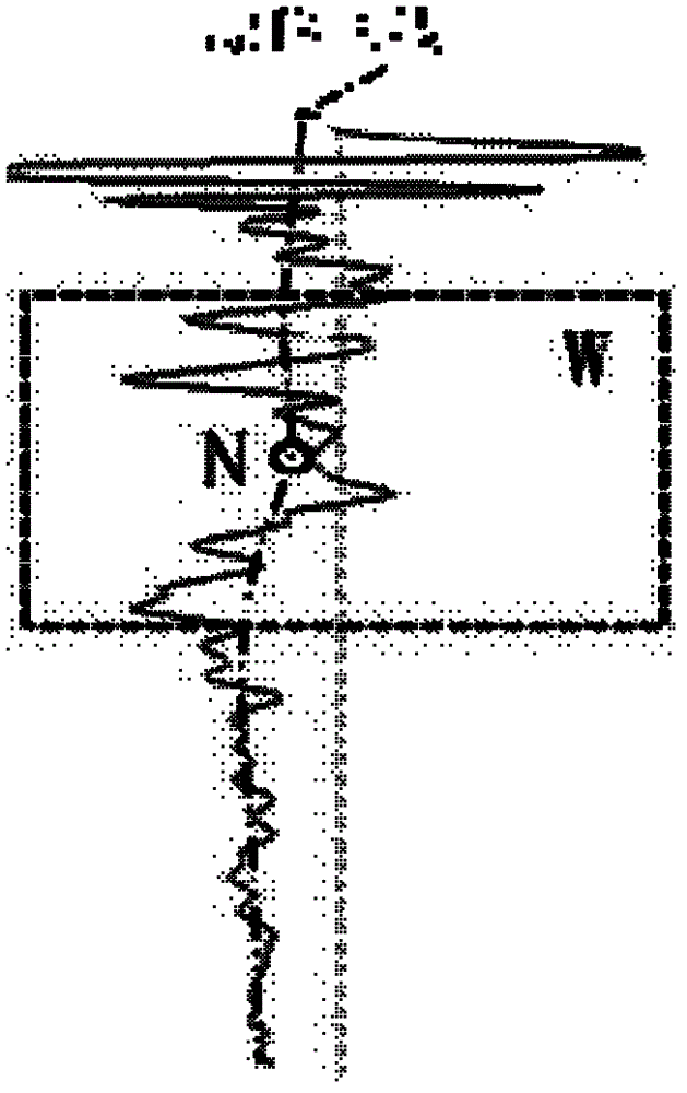
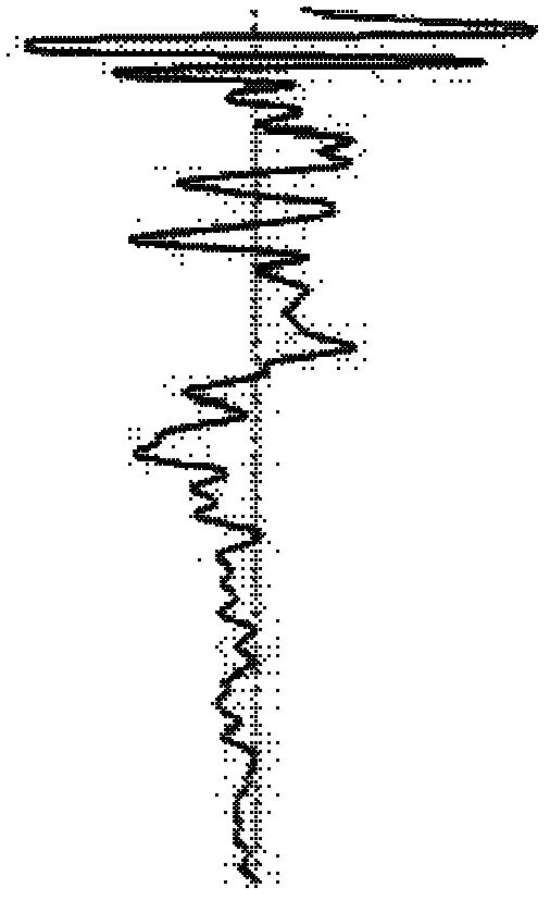
[0055] In this step, the original signal collected by the geological radar such as Figure 2a As shown, the profile image of the original data is as image 3 Shown. In this embodiment, the method for collecting data of the geological radar and ...


PUM


Abstract

The invention discloses a method for determining groundwater occurrence. The method comprises the following steps of: removing interference signals from acquired geological radar data; carrying out computation of the low-frequency signal energy occupancy rate on the geological radar data subjected to interference signal removing, thus obtaining water-containing attribute data; and carrying out profile imaging treatment on the water-containing attribute data, thus displaying the condition of the groundwater occurrence. After the method for determining the groundwater occurrence provided by theinvention is used, not only can the groundwater occurrence condition in a quaternary system stratum be obtained, but also the data obtained by the method is more exact and reliable compared with the data obtained by the direct explanation method in the prior art.

Description

Technical field [0001] The invention relates to the field of geological exploration, and in particular to a method for determining the distribution of groundwater. Background technique [0002] Usually before and after coal mining, geological exploration of the stratum structure is required, and one of the main items of exploration is to determine the distribution of groundwater. [0003] The geological radar is the main equipment for geological exploration. This equipment uses broadband electromagnetic waves to realize the detection of underground concealed targets through the propagation mechanism of electromagnetic waves in the underground medium. Because the geological radar has the characteristics of simple operation, high detection accuracy, and non-destructive detection, it has a wide range of applications in engineering hydrogeological surveys and engineering quality inspections. [0004] At present, the main method of geological radar detection technology in data processing...

Claims


Application Information

Patent Timeline
IPC IPC(8): G01V3/38
Inventor 扬峰崔凡邹冠贵杨俊哲陈苏社
Owner CHINA SHENHUA ENERGY CO LTD
Why Eureka
Try Eureka