GIS (Geographic Information System) data acquisition method applied to unmanned vehicle

A data acquisition and unmanned vehicle technology, applied in the field of GIS data acquisition, can solve the problems of long time interval, insufficient data precision, limited application of dynamic update capability, etc., achieve real-time processing and collection, improve operability, and improve update The effect of efficiency

Inactive Publication Date: 2013-03-27
BEIJING INSTITUTE OF TECHNOLOGYGY
View PDF1 Cites 20 Cited by
  • Summary
  • Abstract
  • Description
  • Claims
  • Application Information

AI Technical Summary

Problems solved by technology

[0004] The dynamic update capability of general geographic information system limits its application in unmanned vehicle navigation
Geographic information is dynamically changing, but the geographic information system is affected by its cost and data update means, and its dynamic update capability is limited. The geographic information provided cannot meet the real-time requirements of unmanned vehicles.
Especially in the field conditions, due to the relatively long time interval of geographic information collection, the collected data is not fine enough, resulting in a certain gap between the existing geographic information data sources and the requirements of unmanned vehicles
Therefore, the help that geographic information can provide will be greatly restricted due to the lag and inapplicability of geographic information

Method used


Image

  • GIS (Geographic Information System) data acquisition method applied to unmanned vehicle
  • GIS (Geographic Information System) data acquisition method applied to unmanned vehicle
  • GIS (Geographic Information System) data acquisition method applied to unmanned vehicle

Examples


Embodiment Construction

[0041] The present invention will be described in detail below with reference to the accompanying drawings and examples.

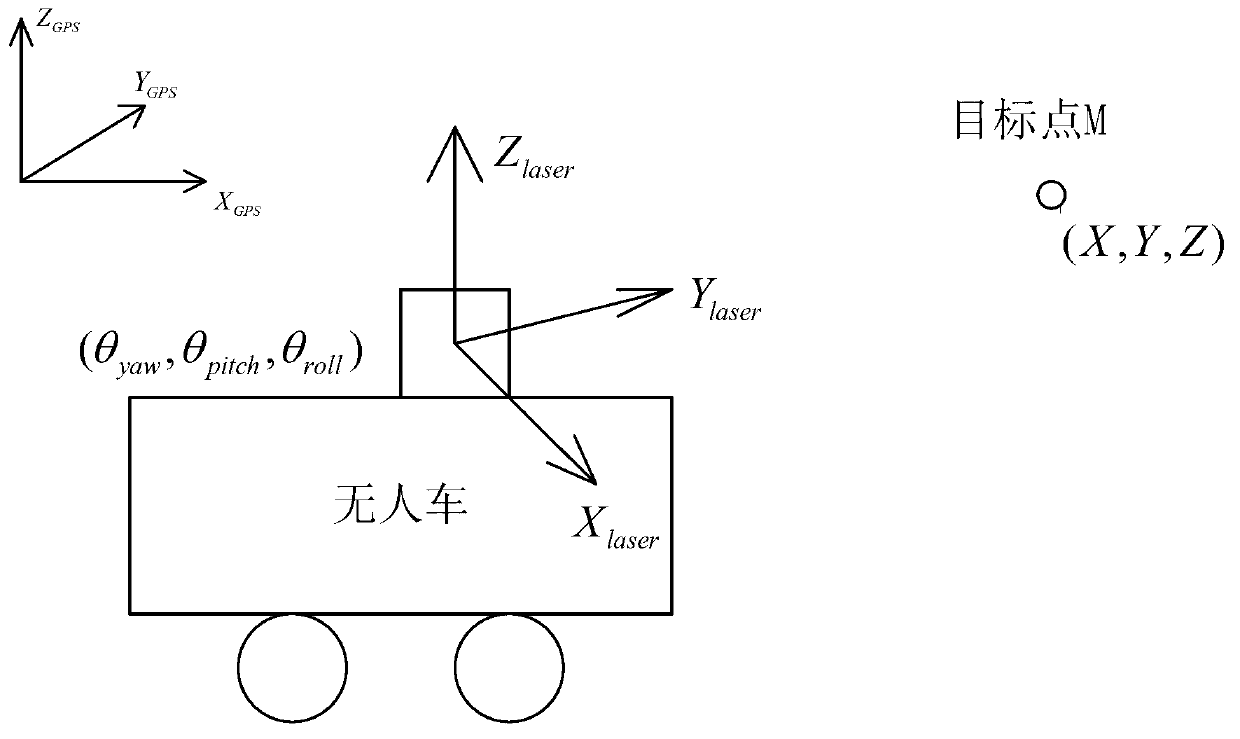
[0042] This embodiment provides a GIS data acquisition method applied to unmanned vehicles. The unmanned vehicles acquire point cloud data by themselves, and according to the requirements of autonomous navigation, set corresponding parameters to extract spatial geographic data, and the acquisition of these geographic data It can be carried out in real time, which greatly improves the update efficiency of geographic data. At the same time, combined with the spatial data processing function of GIS, the obtained geographic data can provide assistance for the autonomous driving of unmanned vehicles.

[0043] In this embodiment, 3D lidar, GPS and IMU (inertial navigation system) are all fixed on the unmanned vehicle, where the IMU can detect the yaw angle θ of the unmanned vehicle yaw , pitch angle θ pitch and roll angle θ roll , the on-board GPS detects the ...


PUM


Abstract

The invention discloses a GIS (Geographic Information System) data acquisition method applied to an unmanned vehicle, which is suitable for dynamic update of GIS of the unmanned vehicle. The method comprises the following steps: obtaining point cloud data through a vehicle-mounted 3D (3-Dimensional) laser radar, and providing auxiliary information for the driving of the unmanned vehicle; and simultaneously setting corresponding parameters to extract geospatial data combined with the detection data of vehicle-mounted inertial navigation system and vehicle-mounted GPS (Global Positioning System), wherein the extraction of the geospatial data can be carried out in real time, so that the updating efficiency of geospatial data is greatly improved, and simultaneously the obtained geospatial data can provide helps for the autonomous running of the unmanned vehicle combined with powerful geospatial data processing function of GIS.

Description

technical field [0001] The invention relates to a GIS data acquisition method applied to unmanned vehicles. Background technique [0002] At present, the research on geographic information system in the field of unmanned vehicles mainly focuses on urban vehicle traffic, and there are few studies on GIS (geographic information system) data acquisition in complex wild environments. [0003] The geographic data provided by the current general-purpose geographic information system is mainly aimed at natural features, specifically describing the spatial characteristics and attribute characteristics of geographic entities, which is difficult to meet the application requirements of unmanned vehicles in the complex field environment. In addition to these basic attributes, unmanned vehicles also need specific spaces and objects such as traversability and concealability, and have higher requirements for data accuracy. [0004] The dynamic update capability of general GIS limits its a...

Claims


Application Information

Patent Timeline
Patent Type & Authority Applications(China)
IPC IPC(8): G01S17/93G01S19/49
Inventor 王美玲于泳杨强荣
Owner BEIJING INSTITUTE OF TECHNOLOGYGY
Why Eureka
Try Eureka