B/S architecture based global Argo multi-source marine data management and visualization system and method

A marine data and S-architecture technology, applied in the field of Internet information interaction technology and marine visualization, can solve problems such as inconvenient data sharing and integration, solve storage management and three-dimensional visualization problems, maintain good maintainability and scalability, and reduce development. and maintenance difficulty and cost effect

Inactive Publication Date: 2013-03-27
北京中海新图科技有限公司 +1
View PDF2 Cites 28 Cited by
  • Summary
  • Abstract
  • Description
  • Claims
  • Application Information

AI Technical Summary

Problems solved by technology

Due to different data sources, it is very inconvenient to sh...

Method used


Image

  • B/S architecture based global Argo multi-source marine data management and visualization system and method
  • B/S architecture based global Argo multi-source marine data management and visualization system and method
  • B/S architecture based global Argo multi-source marine data management and visualization system and method

Examples


Embodiment Construction

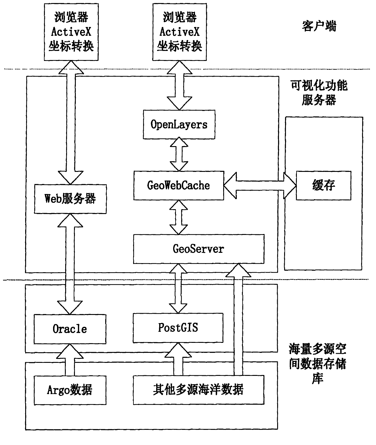
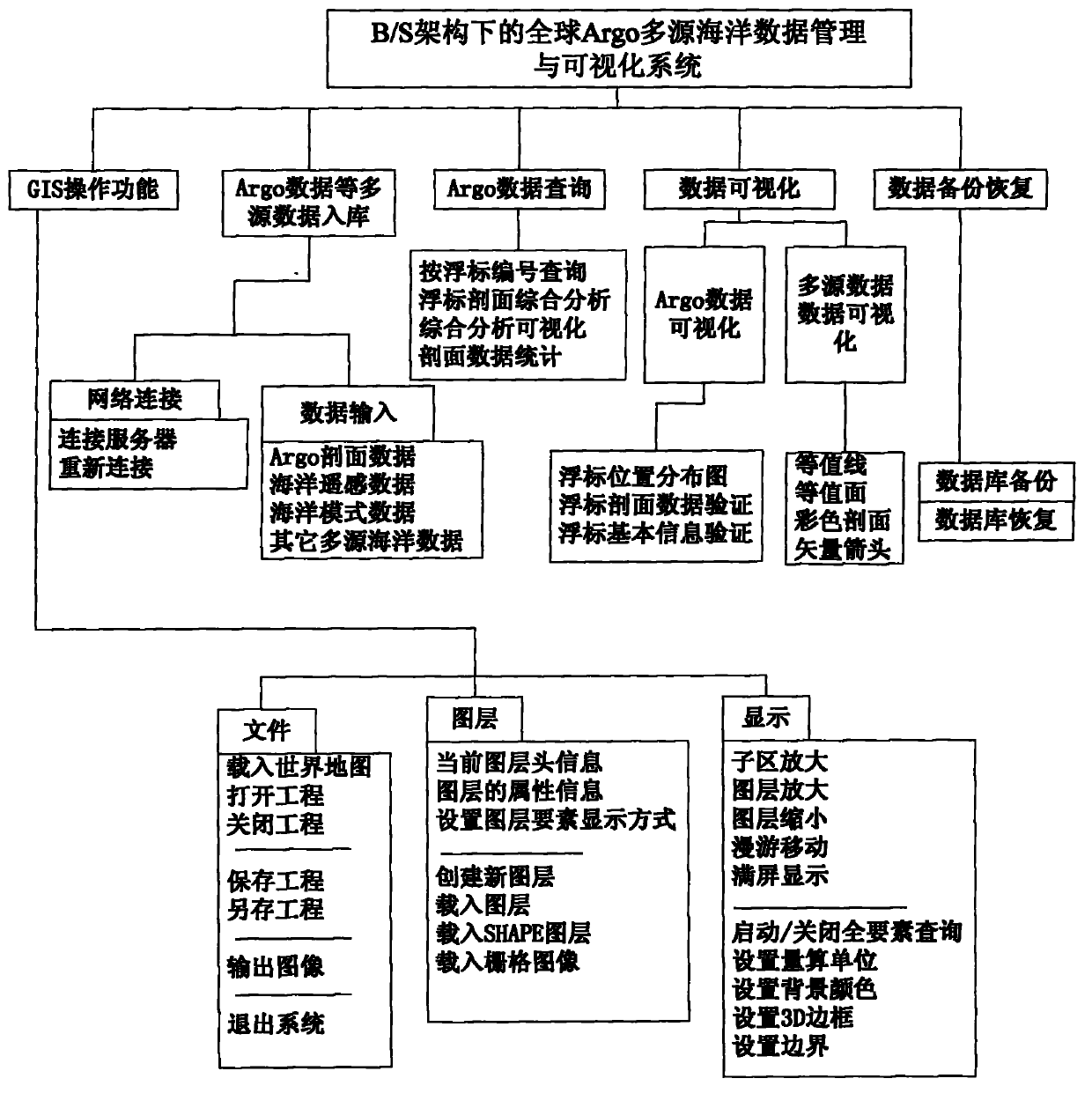
[0025] The functions of the present invention are as figure 2 As shown, it can realize the management and query of Argo data in and out, and can perform three-dimensional visual analysis on multi-source marine data, and can realize the storage and management of massive data. In order to make the above objects, features and advantages of the present invention more comprehensible, the present invention will be further described in detail below in conjunction with the accompanying drawings and specific embodiments.

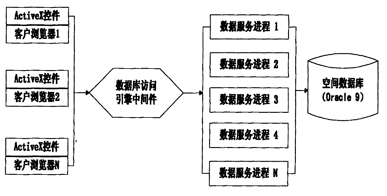
[0026] 1. Massive multi-source spatial data repository structure design and fast query technology

[0027] The data of the global ocean Argo buoy observation network is very huge, and it grows at the GB level every year. Coupled with other model data and remote sensing data, the amount of data will increase. Therefore, it requires the support of massive storage and fast query technology. Due to technical reasons, the query response speed of the database system will...


PUM


Abstract

The invention discloses a B/S architecture based global Argo multi-source marine data management and visualization system and a method and belongs to the field of internet information exchange technology and computer visualization. The system is used for a user to inquire and acquire global marine data in a database management way through three-dimensional visualization by adopting the Web-GIS technology and carry out the analysis of visualization on the multi-source marine data including the mode data and the remote sensing data. The system is completely based on the B/S architecture design and comprises a massive multi-source spatial data storage tank module, a visualization function server module, a client-side interaction and visualization control piece module and a coordinate conversion module. The advanced system makes up the defects of the existing multi-source marine data management system and realizes the massive multi-source data storage, the Argo data inquiring and on-line processing, the three-dimensional data visualization, the real-time interactive analysis and other key technologies by adopting the three-dimensional visualization means of the Web-GIS.

Description

technical field [0001] The present invention relates to the field of Internet information interaction technology and ocean visualization, and more specifically, to a multi-source ocean data management and visual expression system and method based on B / S architecture such as global Argo buoys. Background technique [0002] With the large-scale popularization and widespread use of the Internet, B / S architecture software, as an improvement to the C / S structure, has gradually become the preferred architecture of today's software. [0003] Since the official implementation of the International Argo Program at the end of 2000, a total of 35 countries and organizations in the world have launched about 8,700 Argo profiling buoys in the Atlantic Ocean, Indian Ocean and Pacific Ocean. The total number of buoys is 3,561, and these buoys can provide a total of more than 100,000 seawater temperature and salinity profile data every year. Ocean changes are closely related to abnormal weat...

Claims


Application Information

Patent Timeline
IPC IPC(8): G06F17/30H04L29/08
Inventor 田丰林马纯永于方杰韩勇陈戈吴合义李勃纪鹏波
Owner 北京中海新图科技有限公司
Why Eureka
Try Eureka