Robust multi-source satellite remote sensing image registration method

A technology of satellite remote sensing images and images, applied in image analysis, image data processing, instruments, etc., can solve the problems of many incorrect matching points, time-consuming and laborious, and reduce manual workload, so as to achieve good matching reliability, improve the degree of automation, The effect of reducing the amount of manual editing

Inactive Publication Date: 2013-05-01
HUBEI UNIV OF TECH
View PDF3 Cites 41 Cited by
  • Summary
  • Abstract
  • Description
  • Claims
  • Application Information

AI Technical Summary

Problems solved by technology

[0006] In view of the current automatic registration process of multi-source satellite remote sensing images, there are many wrong matching points, and manual elimination of wrong matching points is time-consuming and laborious. The purpose of this invention is to provide a method based on mutual inf

Method used


Image

  • Robust multi-source satellite remote sensing image registration method
  • Robust multi-source satellite remote sensing image registration method
  • Robust multi-source satellite remote sensing image registration method

Examples


Embodiment 1

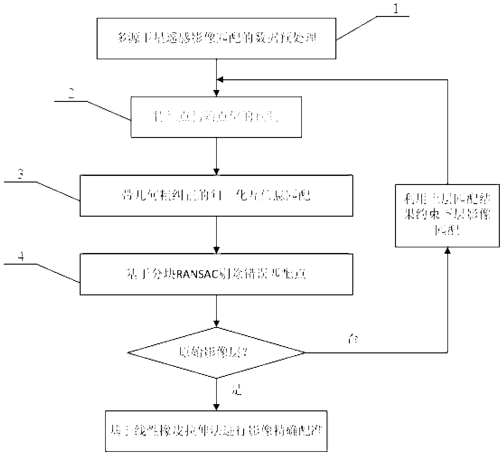
[0023] A multi-source satellite remote sensing image registration method based on mutual information and block RANSAC algorithm, the flow chart is as follows figure 1 As shown, each step is described in detail as follows:

[0024] The first step, data preprocessing for multi-source satellite remote sensing image matching 1:

[0025] The data preprocessing of multi-source satellite remote sensing image matching mainly includes: the generation of pyramid images and the extraction of feature points.

[0026] Specific steps are as follows:

[0027] 1 Pyramid image generation: Use the practical and simple 3×3 pixel averaging method to generate 3-level pyramid images from all images in the survey area. First, calculate the average gray value of every 3×3 pixels of the original image (level 0 pyramid image), and assign it to the corresponding pixel of the first level pyramid image to generate the first level pyramid image. And so on until the second-level pyramid image is generate...


PUM


Abstract

The invention discloses a robust multi-source satellite remote sensing image registration method based on mutual information and block random sample consensus. The method includes the following steps: (A) each layer of pyramid images are generated, and feature points are extracted; (B) on the highest layer of pyramid images, the global registration method is utilized to calculate affine transformation coefficients between the reference image and the slave image, and a rotation angle and a resolution difference coefficient between the images are estimated; (C) the initial positions of homonymy points are accurately predicted, geometric rough correction is carried out on matching window images, and normalized mutual information is utilized to search homonymy points; (D) a quadratic polynomial and a block RANSAC algorithm are utilized to eliminate false matching points; (E) step C and step D are repeated until the original image layer, and accurate image registration is implemented on the basis of the linear rubber sheeting method. The method greatly reduces the workload of manual editing in homonymy point measurement, increases the multi-source satellite remote sensing image data processing automation degree, and can bring remarkable economic and social benefits.

Description

technical field [0001] The invention belongs to the technical field of photogrammetry and remote sensing, and relates to a robust multi-source remote sensing image registration method. This method is based on mutual information image matching and block random sampling consistency technology, which can effectively solve the problem that it is difficult to automatically obtain the same point in multi-source satellite remote sensing images, and realize accurate registration of multi-source satellite remote sensing images. technical background [0002] With the rapid development of earth observation technology, satellite sensors are becoming more and more diverse. In recent years, high-resolution remote sensing satellites have emerged continuously. Optical remote sensing satellites include Ikonos, Quickbird, GeoEye, and WorldView, and SAR remote sensing satellites include TerraSAR-X, Cosmo-Skymed, and Radarsat-2. High-resolution satellite sensors have been widely used in terrai...

Claims


Application Information

Patent Timeline
IPC IPC(8): G06T7/00
Inventor 吴颖丹明洋郑列朱永松
Owner HUBEI UNIV OF TECH
Why Eureka
Try Eureka