LIDAR data city fast reconstruction method based on layered outline

A contour and data technology, applied in the field of rapid urban reconstruction with LIDAR data, can solve problems such as development obstacles, mismatch between aerial orthophoto images and point cloud data, and lack of point clouds

Inactive Publication Date: 2013-05-08
JILIN UNIV
View PDF1 Cites 31 Cited by
  • Summary
  • Abstract
  • Description
  • Claims
  • Application Information

AI Technical Summary

Problems solved by technology

The collection of domestic airborne LIDAR data and aerial images has just emerged. Currently, the data obtained by commonly used laser LIDAR systems often have low point cloud density, missing point clouds, large point cloud noise, no echo, non-orthophoto, and aerial orthophoto images. The problem of mismatching with point cloud data cannot meet the high quality requirements of traditional methods
If you choose to buy an expensive cutting-edge laser LIDAR system from abroad, although it may have better results, its high cost will leave the majority of domestic users beyond the reach, which will inevitably hinder the development of this field in our country.

Method used


Image

  • LIDAR data city fast reconstruction method based on layered outline
  • LIDAR data city fast reconstruction method based on layered outline
  • LIDAR data city fast reconstruction method based on layered outline

Examples


Embodiment Construction

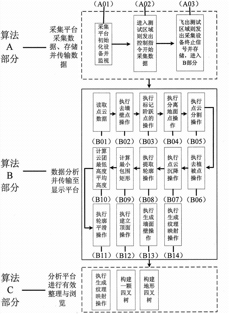
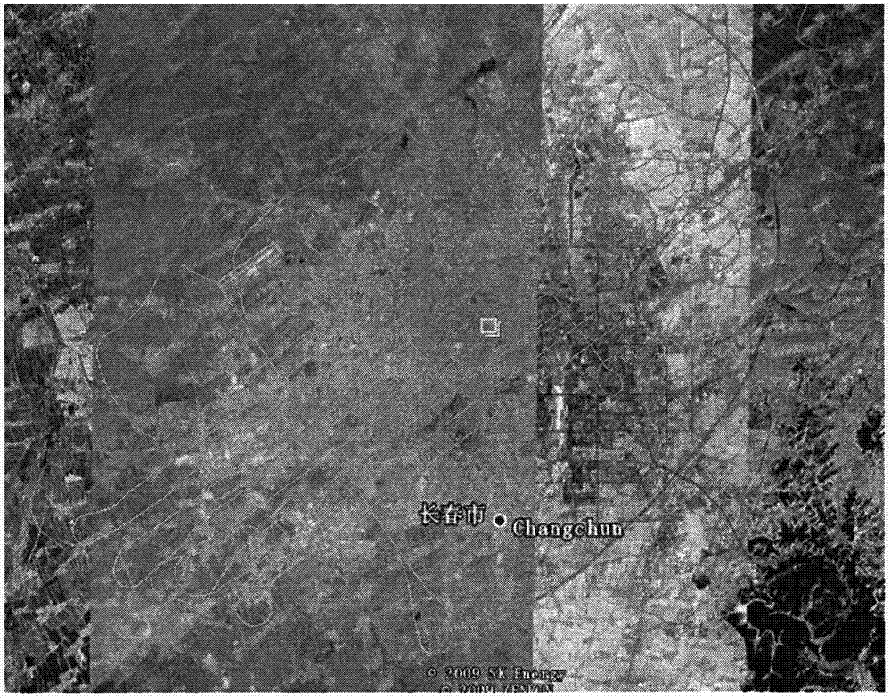
[0053] The specific implementation mode takes the implementation process of this method over Jilin University in Changchun City, Jilin Province as an example. Depend on figure 2 The method implementation process shown is divided into three parts, image 3 It is a map of the specific measurement area division during the test.

[0054] Part A collects the measurement data of the measurement area, including initializing the equipment on the platform and issuing measurement instructions.

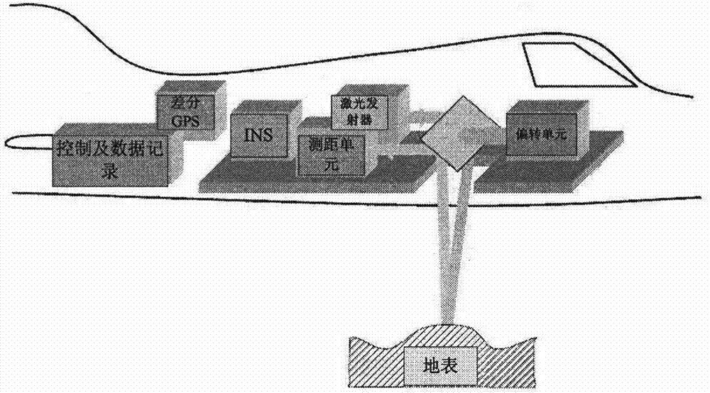
[0055] First, obtain the four coordinate positions of the measurement area, and initialize the laser LIDAR system, high-definition digital camera, and GPS differential module; then, when the flight platform enters the predetermined route over the measurement area, the control and analysis platform sends out a start measurement command, and the laser The LIDAR system, high-definition digital camera, and GPS module start to measure, and store the acquired data in the memory. Figure 4 For the ...


PUM


Abstract

The invention relates to a LIDAR data city fast reconstruction method based on a layered outline. The LIDAR data city fast reconstruction method is designed according to self characteristics of domestic airborne LIDAR data and is capable of still achieving the effect of high efficiency under the condition that the data are low in point cloud density, deficiency in point cloud, large in point cloud noise, free from returning echo, non-normal-incidence and mismatched between aerial photo images and point cloud. The LIDAR data city fast reconstruction method is capable of widely processing current LIDAR data of China, LIDAR data in the collecting part can be obtained through an airborne three-dimensional laser LIDAR, aerial photo orthoimages in the collecting part can be obtained through an airborne high resolution digital camera, and a processing platform and a display part can finish functions through an ordinary personal computer (PC). The LIDAR data city fast reconstruction method based on the layered outline can process rapidly and achieve acceptable effects under the condition that data size is large and the data are not accurate, and is wide in application prospect.

Description

technical field [0001] The method of the present invention relates to a rapid urban reconstruction method based on LIDAR data based on layered contours; the method is designed according to the characteristics of the domestic airborne LIDAR data itself. High-efficiency results can still be obtained when wave, non-orthophoto, and aerial images do not match the point cloud; this method can widely process the current airborne LIDAR data in my country, and part of the collected LIDAR data can be obtained through the airborne 3D laser LIDAR. The aerial orthophotos of the acquisition part can be obtained by an airborne high-resolution digital camera, and the processing platform and display part can be completed by an ordinary PC; this method can still quickly process and obtain Acceptable effect, wide application prospect. Background technique [0002] At present, the building reconstruction technology based on airborne LIDAR data is still in the research and exploration stage. Schol...

Claims


Application Information

Patent Timeline
Patent Type & Authority Applications(China)
IPC IPC(8): G06T17/00G06T15/04G01S17/00
Inventor 李慧盈傅博李文辉张振花
Owner JILIN UNIV
Why Eureka
Try Eureka