Synchronous aerial image assisting airborne laser point cloud error correction method

An aerial image and error correction technology, which is applied in the fields of instrumentation, computing, and electrical digital data processing, etc., can solve the problem that the point cloud correction model does not conform to the point cloud strip error law, etc.

Inactive Publication Date: 2013-05-15
WUHAN UNIV
View PDF7 Cites 29 Cited by
  • Summary
  • Abstract
  • Description
  • Claims
  • Application Information

AI Technical Summary

Problems solved by technology

The point cloud correction model used in ① and ② does not conform to the law of point cloud strip error, and can only roughly correct the point cloud strip error
Method ③Although based on the LiDAR positioning model, only the error of the placement angle of the laser scanner and the POS device is corrected when correcting the point cloud. However, the laser scanner and the POS device in the LiDAR device are highly integrated, and the placement error between the two has a great influence on the positioning accuracy. The impact is generally negligible

Method used


Image

  • Synchronous aerial image assisting airborne laser point cloud error correction method
  • Synchronous aerial image assisting airborne laser point cloud error correction method
  • Synchronous aerial image assisting airborne laser point cloud error correction method

Examples


Embodiment Construction

[0028] During specific implementation, the technical solution of the present invention can adopt computer software technology to realize automatic operation. The technical solution of the present invention will be described in detail below in conjunction with the drawings and embodiments.

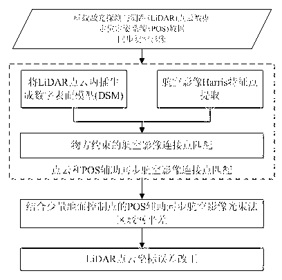
[0029] see figure 1 , the embodiment of the present invention provides an airborne laser point cloud precision optimization method based on synchronous aerial image block adjustment. Perform POS-assisted beam block adjustment on synchronous aerial images to solve POS data system errors, and then correct the coordinate errors of LiDAR points one by one based on the strict model of LiDAR ground positioning. The specific implementation method includes the following steps:

[0030] Step 1. Automatically match the connection points of POS data and LiDAR point cloud-assisted synchronous aerial images.

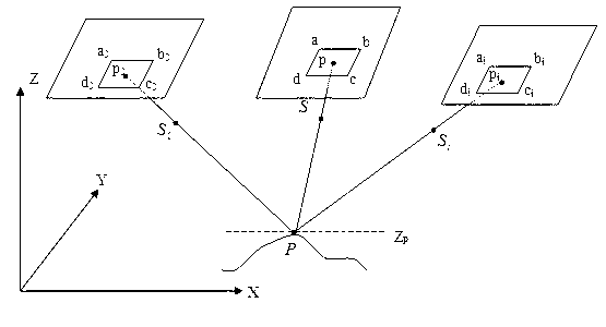
[0031] The embodiment generates a digital surface model (DSM) by interpolating LiDAR point c...


PUM


Abstract

A synchronous aerial image assisting airborne laser point cloud error correction method comprises the steps of combining lidar point cloud and POS data assistance to conduct synchronous aerial image high-precision connecting point automatic matching; combining few ground control points to conduct aerial image POS assistance light beam method block adjustments, and calculating system errors of POS data; and finally strictly locating models on the basis of lidar, and combining global position system (GPS) time of each lidar point, lidar point object space coordinates, POS navigation data files and POS system errors to re-calculate accurate lidar point cloud three-dimension coordinates. The synchronous aerial image assisting airborne laser point cloud error correction method achieves multi-scale and multi-viewpoint image high-precision automatic matching, adopts few ground control points to conduct aerial image POS assistance light beam method block adjustments so as to accurately calculate the POS data system errors; and adopts lidar to strictly locate the model and calculate the POS system errors so as to improve lidar point cloud coordinate precision.

Description

technical field [0001] The invention belongs to the field of surveying and mapping science and technology, and relates to an airborne laser point cloud error correction method assisted by synchronous aerial images. Background technique [0002] Airborne Light Detecting and Ranging (Airborne LiDAR) is a rapid acquisition technology for 3D terrain data that integrates laser scanners and Positioning and Orientation System (Positioning and Orientation System, POS). The airborne LiDAR device emits a laser beam to the ground at a certain frequency and receives the laser signal reflected by the ground object. The distance between the scanner and the ground object is calculated according to the time difference between the transmitted signal and the reflected signal, and then combined with the current attitude of the platform obtained by the POS device to calculate the ground. The three-dimensional coordinates of the object. This process is called direct ground positioning, and the ...

Claims


Application Information

Patent Timeline
Patent Type & Authority Applications(China)
IPC IPC(8): G06F19/00
Inventor 张永军熊小东
Owner WUHAN UNIV
Why Eureka
Try Eureka