Streetscape image stereoscopic model space orientation method based on direction line segment

A three-dimensional model, space orientation technology, applied in photogrammetry/video surveying, measuring devices, instruments, etc., can solve the problem of low work efficiency, large workload of street view photogrammetry and 3D reconstruction, difficult street view surveying and 3D reconstruction. structure and other problems, to achieve the effect of fast operation

Inactive Publication Date: 2013-06-05
HOHAI UNIV
View PDF3 Cites 10 Cited by
  • Summary
  • Abstract
  • Description
  • Claims
  • Application Information

AI Technical Summary

Problems solved by technology

For a stereo image pair, after the relative orientation is completed, the relative orientation between the two photos has been determined, and the model coordinates can be calculated point by point through the forward intersection formula to obtain a three-dimensional model similar to the ground, but the scale of the three-dimensional model is relatively free and in the ground coordinates The orientation in the system is unknown
[0003] At present, the existing absolute orientation method for three-dimensional models is to know the object space coordinates of more than three control points and the corresponding model coordinates, and obtain seven absolute orientation elements through spatial similarity transformation, but it is required to arrange a sufficient number of Control points (signs, signage or feature points), to measure the object space coordinates of each control point, this method is a lot of work in street view photogrammetry and 3D reconstruction, and the work efficiency is extremely low, especially when measuring street view buildings , Blind spots often appear, that is, "difficult to access, unable to deploy control points"
In addition, using the existing photo control method and orientation algorithm to carry out the spatial orientation of the image stereo model, it will be difficult to apply the photogrammetry operation method to street view mapping and 3D reconstruction

Method used


Image

  • Streetscape image stereoscopic model space orientation method based on direction line segment
  • Streetscape image stereoscopic model space orientation method based on direction line segment
  • Streetscape image stereoscopic model space orientation method based on direction line segment

Examples


Embodiment Construction

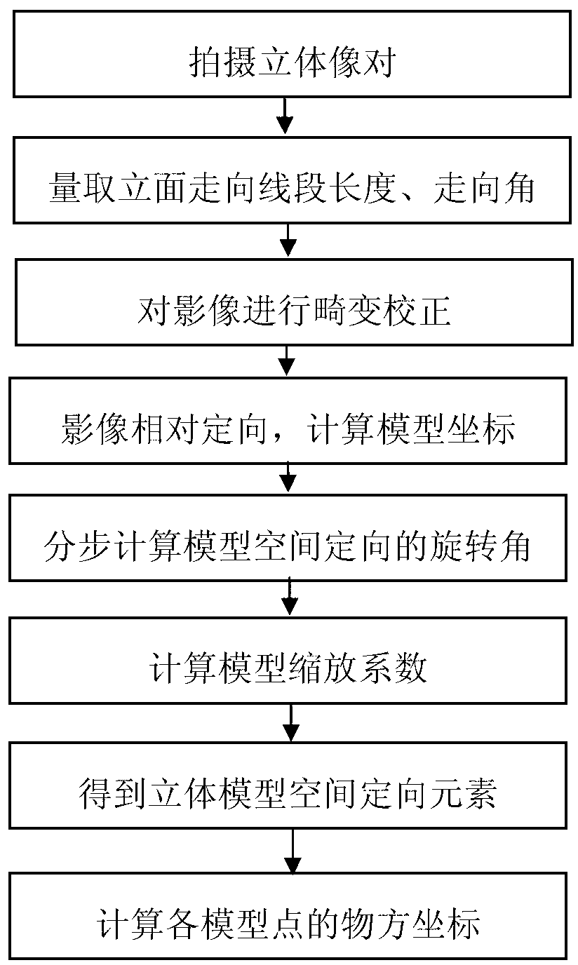
[0022] A method for spatial orientation of a three-dimensional model of a street view image based on azimuth line segments according to the present invention will be described in detail below in conjunction with specific embodiments:

[0023] Such as Figure 1-2 A method for spatial orientation of a three-dimensional model of a street view image based on a bearing segment is shown, the method comprising the following steps:

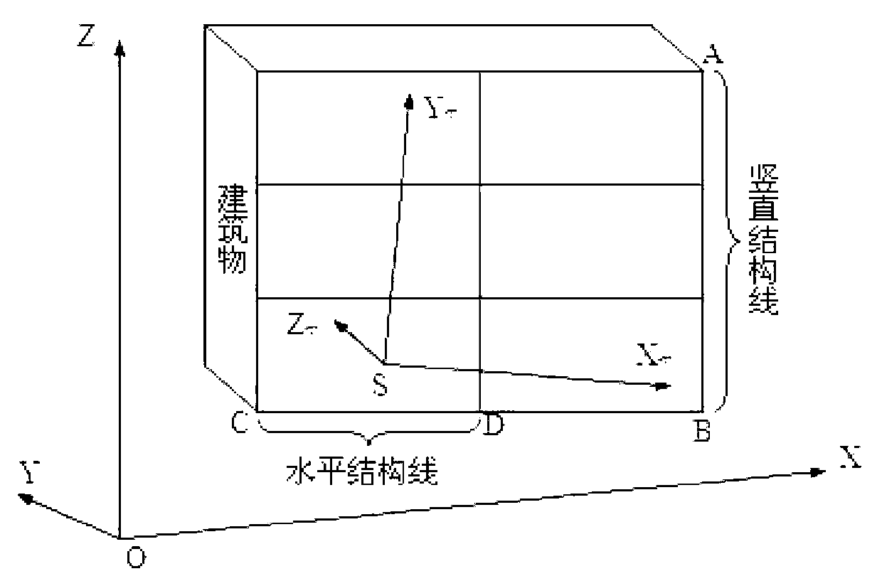
[0024] Step 1. Use a digital camera to collect stereoscopic image pairs of street buildings, and collect information on vertical structural lines and horizontal structural lines on the surface of street buildings to determine the tilt and rotation angle of the image stereoscopic model.

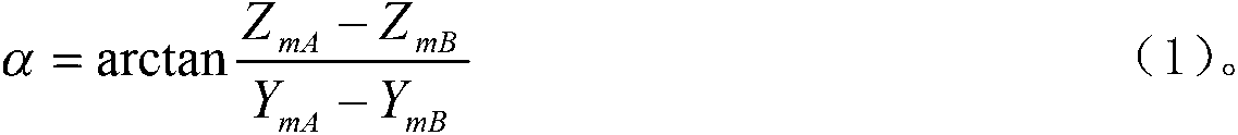
[0025] Step 2, measure the direction angle of the selected facade direction line segment on the building, which is used to determine the azimuth rotation angle of the three-dimensional model, and measure the length of the direction direction line segment of the facade, wh...


PUM


Abstract

The invention discloses a streetscape image stereoscopic model space orientation method based on a direction line segment. The method includes the following steps: using a digital camera to collect stereoscopic image pairs of a street building, collecting vertical structure line information of the surface of the street building and horizontal structure line information of the surface of the street building to be used for determining an inclined rotary angle of an image stereoscopic model; measuring a running angle of a selected vertical face running line segment on the building to be used for determining a stereoscopic model orientation rotary angle; measuring the length of the vertical face running line segment to be used for determining a stereoscopic model scaling measuring scale, conducting image orientation treatment which comprises image distortion correction, image relative orientation, model coordinate calculation, module space orientating rotary angle step-by-step calculation, model scaling coefficient calculation, and model space translation amount calculation, and each image point corresponding coordinate calculation. The method is free of arranging object space control points, quick in working speed, convenient and easy to operate, and capable of largely improving working efficiency of streetscape photogrammetry and three-dimensional reconstruction field collection work.

Description

technical field [0001] The invention relates to the technical field of photogrammetry, in particular to a spatial orientation method for a three-dimensional model of a street view image based on azimuth line segments. Background technique [0002] In the work of photogrammetry, in order to determine the position, shape, size and other information of the researched object from the image, the analytical relationship between the object space and the image space is mainly used to obtain it through calculation. For a stereo image pair, after the relative orientation is completed, the relative orientation between the two photos has been determined, and the model coordinates can be calculated point by point through the forward intersection formula to obtain a three-dimensional model similar to the ground, but the scale of the three-dimensional model is relatively free and in the ground coordinates The orientation in the system is unknown. [0003] At present, the existing absolute...

Claims


Application Information

Patent Timeline
Patent Type & Authority Applications(China)
IPC IPC(8): G01C11/00
Inventor 李浩杨彪毛羽丰刘晓燕张荣春吴铭飞
Owner HOHAI UNIV
Why Eureka
Try Eureka