Airborne interference synthetic aperture radar (SAR) shadow estimate and plane route design method

A technology of route design and shadow, applied in the field of radar detection

Active Publication Date: 2013-06-05
INST OF ELECTRONICS CHINESE ACAD OF SCI
View PDF3 Cites 6 Cited by
  • Summary
  • Abstract
  • Description
  • Claims
  • Application Information

AI Technical Summary

Problems solved by technology

[0007] In order to solve the problem of airborne interferometric SAR shadow estimation in low signal-to-noise ratio area and route design basis, the present invention proposes an airborne interferometric SAR shadow estimation and route design method, which not only considers the shadow brought by radar imaging geometry, but also considers the For the shadows caused by low signal-to...

Method used


Image

  • Airborne interference synthetic aperture radar (SAR) shadow estimate and plane route design method
  • Airborne interference synthetic aperture radar (SAR) shadow estimate and plane route design method
  • Airborne interference synthetic aperture radar (SAR) shadow estimate and plane route design method

Examples


Embodiment Construction

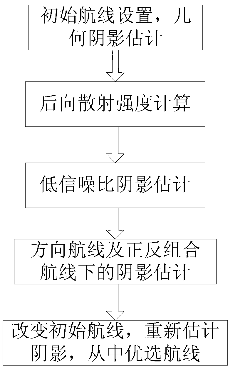
[0022] like figure 2 As shown, an airborne interferometric SAR shadow estimation and route design method consists of 5 steps, and the specific steps are implemented as follows:

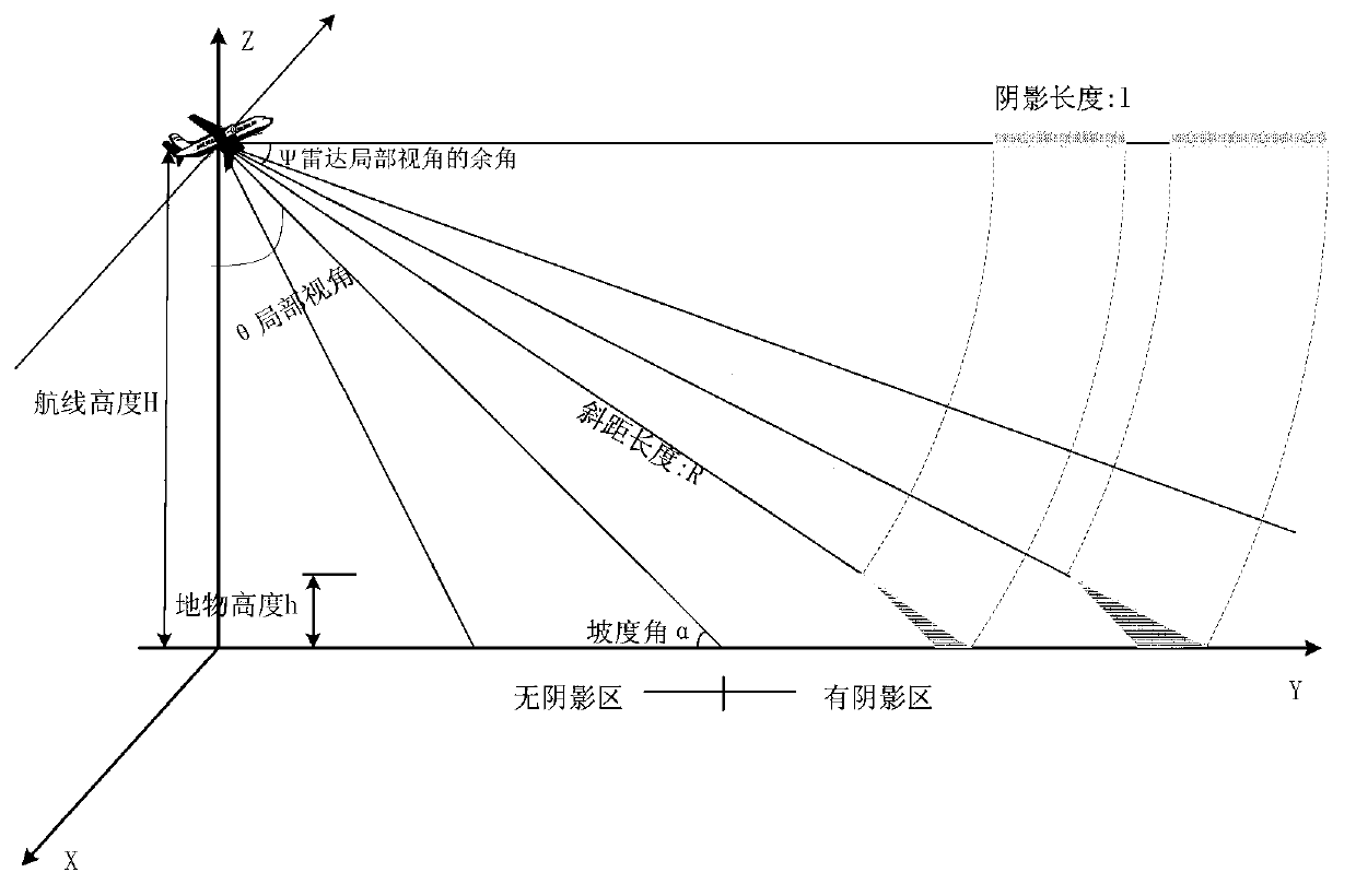
[0023] Step 1: Firstly, according to the position of the survey area, the angle of view of the center of the radar, and the width of the beam in the range direction, an initial route that can cover the survey area is set according to the traditional method, and the survey area is divided into grid units by means of a rough DEM of the survey area. Calculate the slope angle, radar local viewing angle, and shadow length of each grid unit one by one from the beginning, judge whether the grid unit is a geometric shadow, and count the proportion of the geometric shadow to the area of ​​the survey area;

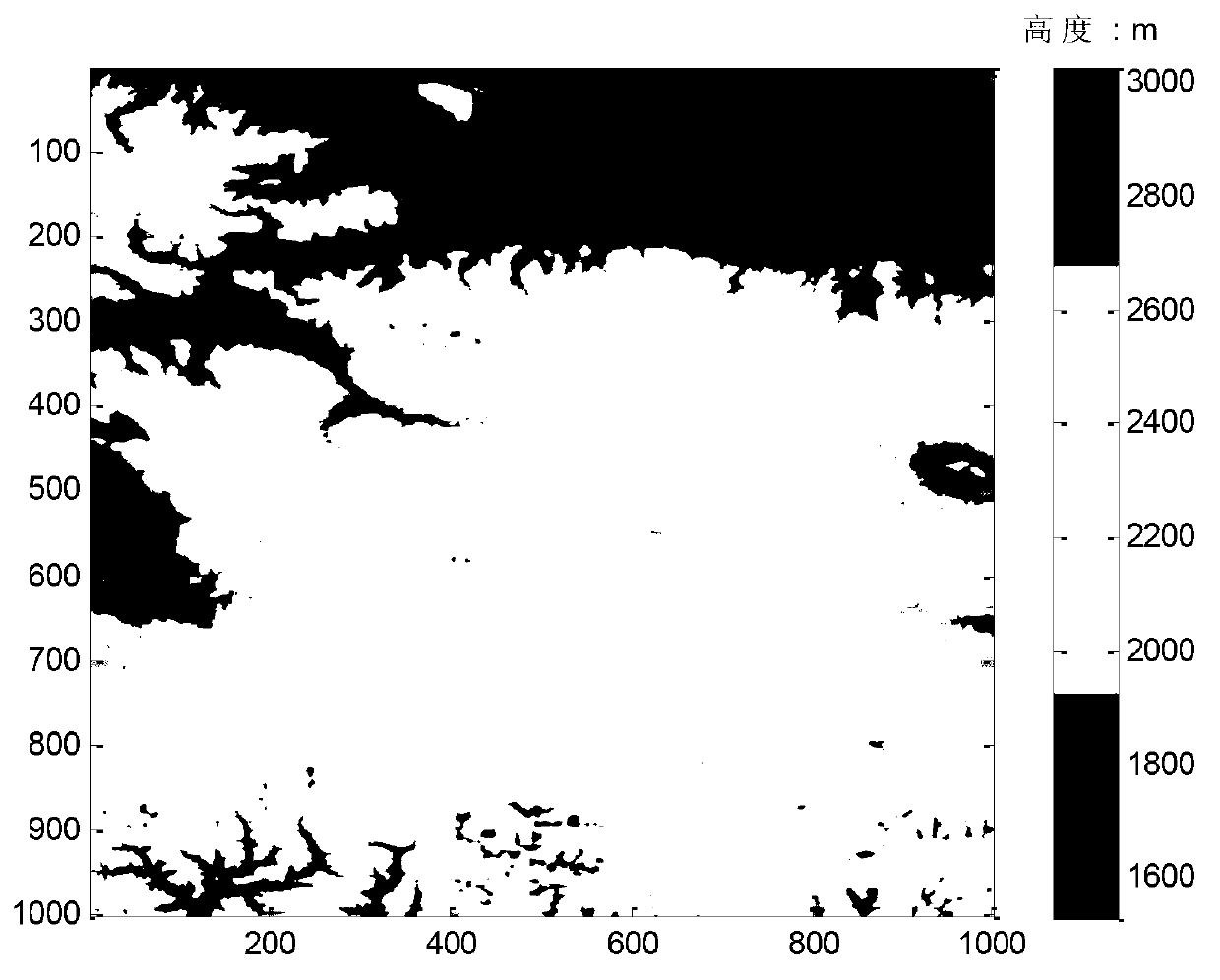
[0024] For example, assume that the center of the survey area is located at N30° north latitude, E89° east longitude, the area is 3km*3km, the rough DEM of the survey area is known (1600m~3000m), and the a...


PUM


Abstract

The invention provides an airborne interference synthetic aperture radar (SAR) shadow estimate and plane route design method for resolving the problems of an airborne SAR low signal-to-noise ratio zone shadow estimate basis and a plane route design basis. The airborne interference SAR shadow estimate and plane route design method comprises the steps: step1, providing an initial plane route which can cover a measuring zone, and calculating a gradient angle, a radar part view angle, and a shadow length of each grid unit; step2, utilizing a backscattering coefficient model to calculate ground backscattering strength inside each grid unit under each ground covering condition; step3, calculating the low signal-to-noise ratio zone shadow estimate basis, distinguishing and marking whether the unit is low signal-to-noise ratio or not, and counting the proportion of the area in which the low signal-to-noise ratio shadow zone occupies the measuring zone; step4; judging and marking a geometry shadow and the low signal-to-noise ratio zone shadow in the plane route direction, and counting a proportion of the area in which the two shadows occupy the measuring zone; step 5, changing the initial plane route which is set in the step 1, repeating step1-step4, and selecting a plane route which is smallest in shadow proportion after the shadows are combined.

Description

technical field [0001] The invention belongs to the technical field of radar detection, and in particular relates to an airborne interferometric SAR shadow estimation and route design method. Background technique [0002] In interferometric synthetic aperture radar (Synthesis Aperture Radar: SAR) radar mapping applications, it is usually desired to reduce shadows, thereby reducing invalid data and improving the quality of interferometric SAR mapping data. Shadows are the main component of geometric distortion of interferometric SAR images. [0003] In traditional SAR shadow analysis, usually only the geometric relationship of radar imaging is considered, that is, under a certain radar viewing angle, the area that is not illuminated by the radar beam is called shadow (a part of geometric distortion). For the application of interferometric SAR mapping, not only traditional SAR shadows (or called geometric shadows) need to be considered, but also some areas with weak scattering...

Claims


Application Information

Patent Timeline
IPC IPC(8): G01C21/00G01S13/90G06T5/00G06T7/00
Inventor 陈龙永王宇汪丙南梁兴东丁赤飚
Owner INST OF ELECTRONICS CHINESE ACAD OF SCI
Why Eureka
Try Eureka