Three-dimensional modeling method for achieving building inside and outside integration in digital map

A digital map and three-dimensional modeling technology, applied in 3D modeling, image data processing, instruments, etc., can solve problems that are difficult to realize, and achieve the effects of reducing costs, improving efficiency, and strong operability

Active Publication Date: 2013-06-12
江苏易图地理信息科技有限公司
View PDF5 Cites 54 Cited by
  • Summary
  • Abstract
  • Description
  • Claims
  • Application Information

AI Technical Summary

Problems solved by technology

However, in this case, when using the blueprint to input information, it needs to be based on complex rules and use the rules to perform conversions
That means a lot of manual data entry is required.
This technology is feasible for a single building, but for the field of large-scale digital maps, modeling a large number of buildings on the map one by one has an unimaginable workload, which is actually difficult to achieve

Method used


Image

  • Three-dimensional modeling method for achieving building inside and outside integration in digital map
  • Three-dimensional modeling method for achieving building inside and outside integration in digital map
  • Three-dimensional modeling method for achieving building inside and outside integration in digital map

Examples


Embodiment Construction

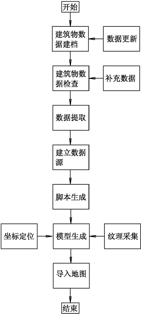
[0032] Such as figure 1 , for realizing the flowchart of the three-dimensional modeling method of building inside and outside integration in digital map, this method is carried out as follows:

[0033] Step 1, building data files:

[0034] Collect the CAD drawings of building construction in the target area, and put the CAD drawings of the same coordinates into the same named folder; in this embodiment, the CAD drawings of Tianzheng Architecture are collected, and the CAD drawings are derived from the planning and construction project data, such as the approved Documents, general plans, construction drawings, etc. When building a file, the construction drawing data is the basis, and the planning application documents and table data are auxiliary.

[0035] The following is an example of the construction application data for construction project planning permits.

[0036] A. Building construction drawing CAD data

[0037] The CAD data of the planning report generally provide...


PUM


Abstract

The invention discloses a three-dimensional modeling method for achieving building inside and outside integration in a digital map and belongs to the technical field of digital map manufacture. The three-dimensional modeling method comprises the steps of firstly, filing building data; then checking building data; extracting data until all data are right; building a data source; generating a MAXScript script according to the data source and using 3DMAX to convert a MAXScript script file into a three-dimensional model; and finally guiding into a map to finish three-dimensional modeling of the building inside and outside integration in the digital map. The three-dimensional modeling method can economically and quickly achieve a three-dimensional digital map with building information and provides decision basis for urban construction and management.

Description

technical field [0001] The present invention relates to a digital map, in particular to a method for batch modeling and updating of buildings integrated inside and outside in the digital map. Background technique [0002] With the deepening of digital city construction, "virtual city" and "three-dimensional planning" provide people with a new concept and means of urban planning, construction and management. Compared with the traditional use of graphic design drawings, data tables, and sand table models for urban planning management, "3D planning" based on 3D virtual reality technology has many advantages, especially in the stages of planning and design, planning approval, and architectural design. Technology can enable people to conduct an immersive and comprehensive inspection of future planning buildings or areas in a virtual three-dimensional environment in a dynamic and interactive way. Therefore, "three-dimensional planning" will gradually become an important means of u...

Claims


Application Information

Patent Timeline
Patent Type & Authority Applications(China)
IPC IPC(8): G06T17/00G06T19/00
Inventor 陈正富熊焰袁志和赵志强李学锡王山扣沈刚
Owner 江苏易图地理信息科技有限公司
Why Eureka
Try Eureka