
Positioning method and system for real navigation and computer readable storage medium

A positioning method and real scene technology, applied in satellite radio beacon positioning systems, navigation, surveying and navigation, etc., can solve the problems of wrong navigation information, ineffective navigation in real scenes, and inability to navigate, and achieve the effect of improving accuracy

Inactive Publication Date: 2013-10-23
WISTRON CORP
View PDF8 Cites 3 Cited by
  • Summary
  • Abstract
  • Description
  • Claims
  • Application Information

AI Technical Summary

Problems solved by technology

However, when the accuracy of GPS positioning is reduced or the navigation device is in a sheltered environment and cannot locate, the navigation information will be wrong or the navigation cannot be performed, making the real-scene navigation useless

Method used


Image

  • Positioning method and system for real navigation and computer readable storage medium
  • Positioning method and system for real navigation and computer readable storage medium
  • Positioning method and system for real navigation and computer readable storage medium

Examples


Embodiment Construction

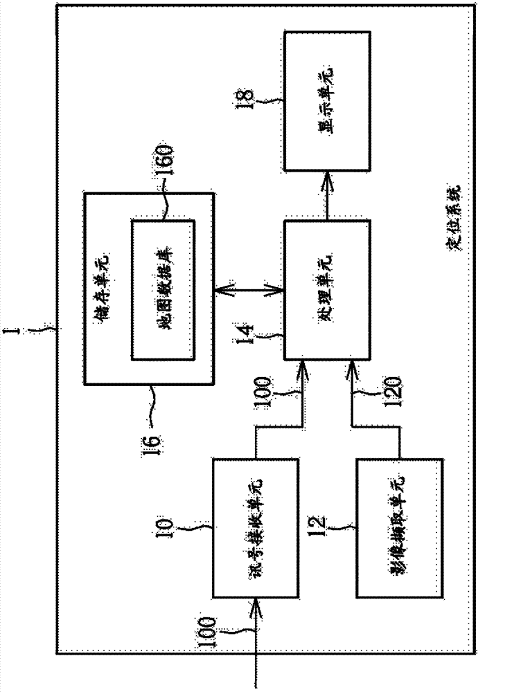
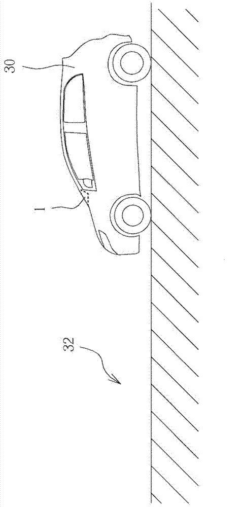
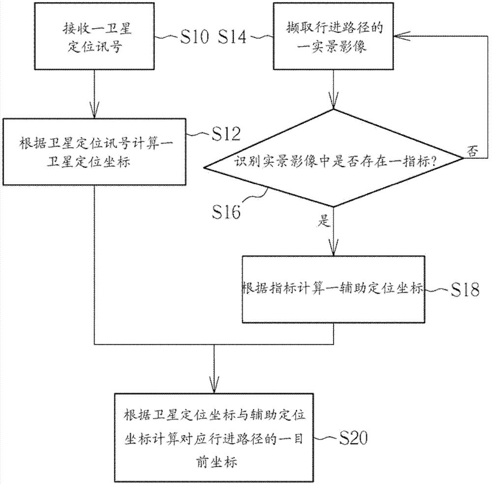
[0036] see Figure 1 to Figure 4 , figure 1 It is a functional block diagram of a positioning system 1 for real scene navigation according to an embodiment of the present invention, figure 2 for figure 1 The schematic diagram of the positioning system 1 installed in the vehicle 3 in image 3 It is a flowchart of a positioning method for real scene navigation according to an embodiment of the present invention, Figure 4 for image 3 The detailed flowchart of step S110 in, wherein image 3 The positioning method in figure 1 The positioning system 1 in is realized.

[0037] Such as figure 1As shown, the positioning system 1 includes a signal receiving unit 10, an image capturing unit 12, a processing unit 14, a storage unit 16 and a display unit 18, wherein the processing unit 14 is electrically connected to the signal receiving unit 10, the image capturing unit fetching unit 12 , storage unit 16 and display unit 18 . In practical applications, the positioning system 1...


PUM


Abstract

Provided are a positioning method and system for real navigation and a computer readable storage medium. The positioning method for real navigation includes steps of receiving a satellite positioning signal; calculating a satellite positioning coordinate according to the satellite positioning signal; capturing a real scene image of a driving path; recognizing whether an indicator exists in the real scene image; if the indicator exists in the real scene image, calculating an auxiliary positioning coordinate according to the indicator; and calculating a current coordinate corresponding to the driving path according to the satellite positioning coordinate and the auxiliary positioning coordinate.

Description

technical field [0001] The invention relates to a positioning method and a positioning system, in particular to a positioning method and a positioning system for real scene navigation. Background technique [0002] With the mature development of the Global Position System (GPS) and various electronic devices (such as smart phones), the functions of car navigation are becoming more and more perfect and diversified. realized in. Most of the electronic devices that support real-world navigation currently on the market use built-in cameras to capture real-world images, and display the captured real-world images in real-time in the navigation software, replacing the maps in the 2D or 3D map database of the original navigation software. . Combined with the navigation information displayed by the original navigation software, the user can more clearly understand the route indicated by the navigation software on the real street, which greatly improves the recognition rate of the n...

Claims


Application Information

Patent Timeline
Patent Type & Authority Applications(China)
IPC IPC(8): G01C21/26G01S19/42
CPCG01S19/45G01C21/3647G01C21/26
Inventor 张志崧
Owner WISTRON CORP
Learn More