
Seabed sand wave geomorphology movement detection method based on MBES (multi-beam echo sounding)

A detection method and motion technology, which is applied in the directions of measuring devices, surveying and navigation, open-air water source surveying, etc.

Active Publication Date: 2013-11-13
SECOND INST OF OCEANOGRAPHY MNR
View PDF4 Cites 23 Cited by
  • Summary
  • Abstract
  • Description
  • Claims
  • Application Information

AI Technical Summary

Problems solved by technology

From the public data analysis of retrieval, still do not have the method fully consistent with the present invention to be applicable to the detection and calculation problem of seabed sand wave topography

Method used


Image

  • Seabed sand wave geomorphology movement detection method based on MBES (multi-beam echo sounding)
  • Seabed sand wave geomorphology movement detection method based on MBES (multi-beam echo sounding)
  • Seabed sand wave geomorphology movement detection method based on MBES (multi-beam echo sounding)

Examples


Embodiment 1

[0058] The detection and calculation method of seabed sand wave geomorphic motion based on MBES is realized according to the following steps.

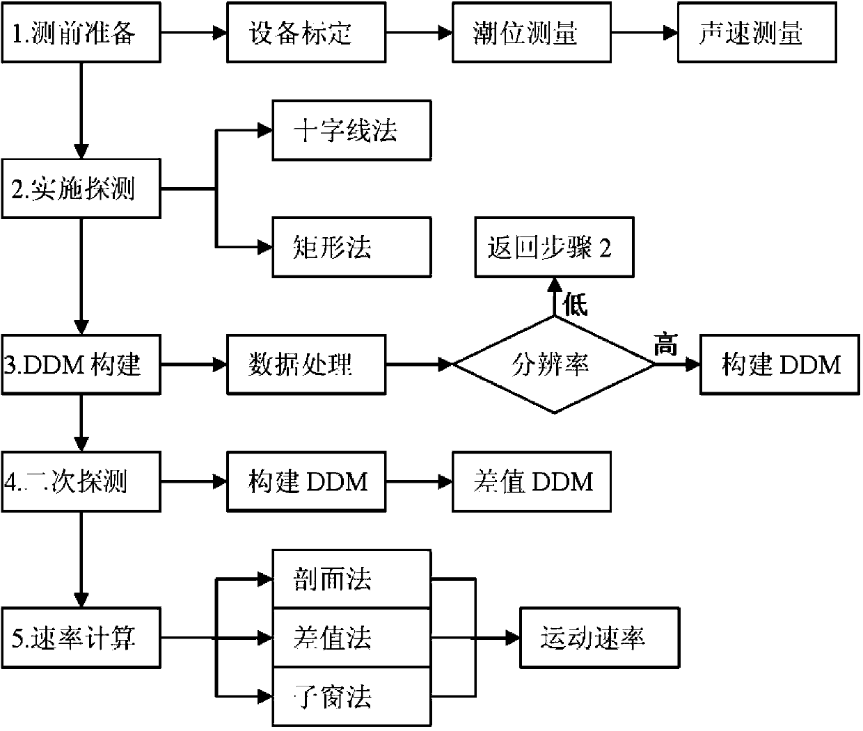
[0059] Detailed steps and flow process of the present invention see figure 1 .

[0060] Step 1: Preparations for MBES-based submarine sand wave detection

[0061] (1) Equipment testing and calibration: The multi-beam bathymetry system is a complex submarine topography detection system. Before the measurement, all instruments and equipment must be self-calibrated in accordance with the national standard GB / T 12763.10-2007 or sent to a legal metrology institution. Calibrate to ensure that all sensors are in normal working condition and that the accuracy of the instrument meets the requirements of the national standard. The depth sounding accuracy of the multi-beam system reaches the decimeter or even centimeter level, and the GPS positioning accuracy reaches the submeter or decimeter level.

[0062] (2) Arrangement of tide level stati...


PUM


Abstract

The invention discloses a method of hydrographic surveying and charting and submarine topography geomorphologic survey research, and particularly discloses a seabed sand wave geomorphology movement detection method based on MBES (multi-beam echo sounding). The method provided by the invention adopts a decimeter grade measurement accuracy multi-beam sounding technology and a sub-meter grade positional accuracy navigational positioning system, the movement rate and direction of the seabed sand wave geomorphology are obtained through preparation before seabed sand wave detection based on the MBES, the detection of the seabed sand wave geomorphology based on the MBES, a DDM (difference of depth of modulation) construction based on the MBES measured data, secondary detection and treatment as well as sand wave movement rate calculation. The invention provides an exquisite detection scheme of a seabed sand wave movement and a rapid construction method of seabed grids and further provides an exact calculating method of the movement rate of the seabed sand wave, the methods have the important application values for hydrographic surveying and charting, oceanographic survey and seabed scientific research in a seabed high active region.

Description

technical field [0001] The invention relates to the technical fields of marine surveying and mapping, investigation and research of seabed topography and geomorphology, seabed science, etc., and specifically refers to an MBES-based method for detecting motion of seabed sand wave geomorphology. Background technique [0002] Multi-Beam Echo Sounding (MBES, Multi-Beam Echo Sounding) technology represents the latest high-tech achievements in the field of contemporary sounding, and is a comprehensive processing system with complex integration of multiple sensors and high fusion of multi-source data. The multi-beam sounding system sprouted in the 1960s from the needs of the US Navy, began commercialization in the 1980s, and was introduced to China in the 1990s and applied on a large scale. Compared with traditional single-beam sounding, multi-beam sounding has remarkable characteristics of high resolution, high precision, high efficiency and full coverage. This technology is curr...

Claims


Application Information

Patent Timeline
IPC IPC(8): G01C13/00
Inventor 吴自银余威李守军尚继宏赵荻能周洁琼金肖兵
Owner SECOND INST OF OCEANOGRAPHY MNR
Learn More