Vision navigating method for movement carrier based on laser plane assistance

A motion carrier and visual navigation technology, applied in directions such as navigation, mapping and navigation, line-of-sight measurement, etc., can solve the problems of ambiguity, distance, and insufficient information in three-dimensional world coordinate space.

Active Publication Date: 2013-12-04
NANJING UNIV OF AERONAUTICS & ASTRONAUTICS
View PDF6 Cites 28 Cited by
  • Summary
  • Abstract
  • Description
  • Claims
  • Application Information

AI Technical Summary

Problems solved by technology

[0005] The technical problem to be solved by the present invention is the spatial ambiguity of the three-dimensional world coordinates obtained through the derivation of the two-dimensional image coordinates in...

Method used


Image

  • Vision navigating method for movement carrier based on laser plane assistance
  • Vision navigating method for movement carrier based on laser plane assistance
  • Vision navigating method for movement carrier based on laser plane assistance

Examples


Embodiment Construction

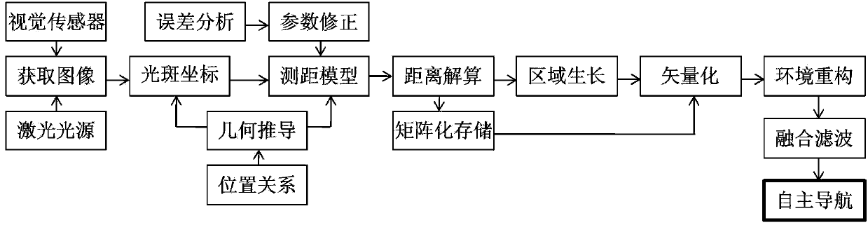
[0035] The laser plane-assisted visual navigation method for moving carriers in this embodiment includes the following steps:

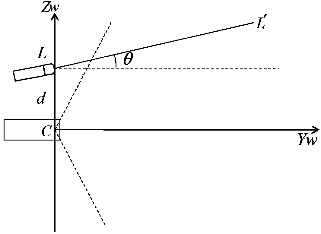
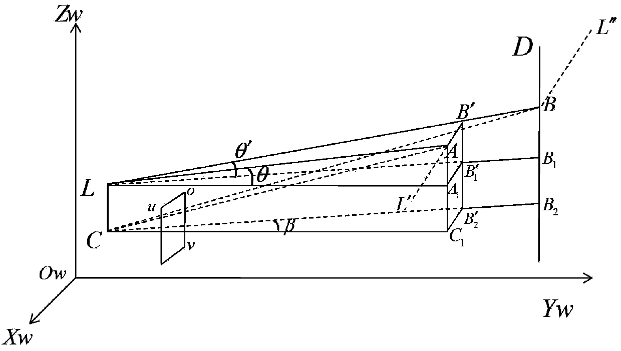
[0036] Step 1: Use the laser light source and vision sensor installed on the moving carrier as a distance measurement and environment construction system. The laser light source is used to emit a laser plane, which is reflected on the object to be measured in front of the carrier to form a linear bright spot, and then the visual image containing the linear bright spot is captured by a visual sensor; Step 2: Determine a spot in the image obtained in Step 1 Group the bright spot to be measured and its coordinate range, and use the template matching method to search and determine the position of the rectangular bright spot to be measured in the image, where:

[0037] R ( i , j ) = Σ m ...


PUM


Abstract

The invention discloses a vision navigating method for a movement carrier based on the laser plane assistance. The method comprises the following steps: building a distance measurement and environment system, determining the position of a rectangular bright spot to be detected in an image, determining the center coordinate of the rectangular bright spot, obtaining a geometric distance measurement model, correcting the distance measurement model, segmenting the visual image, determining a local vectorization environmental space with distance information, positioning the position of the carrier per se, and building a global environmental space. Through the adoption of the method different from the traditional movement carrier autonomous navigation middle distance obtaining method, a laser plane is introduced as an auxiliary means, a single or a plurality of vision sensors are combined, the threadlike bright spot formed by the reflection of the laser plane on an object to be irradiated is fully utilized and taken as an cooperated distance measurement target, and the geometric relationship between the vision sensor and a laser light source is effectively utilized, so that the requirements for the precision, yield ratio and real-time performance of the distance calculating can be met. Therefore, the method is a reliable navigation method, and can be applied to a movement carrier autonomous navigation system.

Description

technical field [0001] The invention relates to a visual navigation method for a moving carrier, in particular to a method for visual rangefinding and navigation with laser plane assistance, and belongs to the field of autonomous navigation of a moving carrier. Background technique [0002] In the absence of high-precision real-time external environmental information input, it is difficult for various moving carriers to achieve autonomous navigation through inertial / GNSS systems. The use of vision technology to realize high-precision perception and avoidance of unknown obstacles by moving carriers can effectively improve the application capabilities of carriers. Monocular or multi-eye vision has broad application prospects in the field of indoor and outdoor navigation due to its simple structure, low power consumption, and small size. Researching the distance measurement technology based on the laser-assisted moving carrier to the obstacle in front and estimating the collis...

Claims


Application Information

Patent Timeline
IPC IPC(8): G01C21/00G01C3/00
Inventor 曾庆化邓孝逸王云舒赵伟刘建业熊智赖际洲李荣冰
Owner NANJING UNIV OF AERONAUTICS & ASTRONAUTICS
Why Eureka
Try Eureka