Method for shortening time to first fix of GNSS receiver and system thereof

A receiving device and positioning time technology, applied in the field of satellite navigation signal processing, to achieve the effects of improving positioning efficiency, reducing resource overhead, and shortening the first positioning time

Active Publication Date: 2013-12-25
TECHTOTOP MICROELECTRONICS
View PDF4 Cites 5 Cited by
  • Summary
  • Abstract
  • Description
  • Claims
  • Application Information

AI Technical Summary

Problems solved by technology

Still another general method is to use a server to continuously (continuously) collect and provide the orbit and clock data of the global navigation satellite system currently in use (it will be valid for an extended period of time in the future), a

Method used


Image

  • Method for shortening time to first fix of GNSS receiver and system thereof
  • Method for shortening time to first fix of GNSS receiver and system thereof
  • Method for shortening time to first fix of GNSS receiver and system thereof

Examples


Embodiment Construction

[0040] In order to make the object, technical solution and advantages of the present invention clearer, the present invention will be further described in detail below in conjunction with the accompanying drawings and embodiments. It should be understood that the specific embodiments described here are only used to explain the present invention, not to limit the present invention.

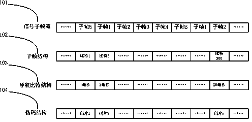
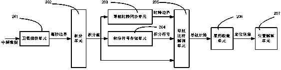
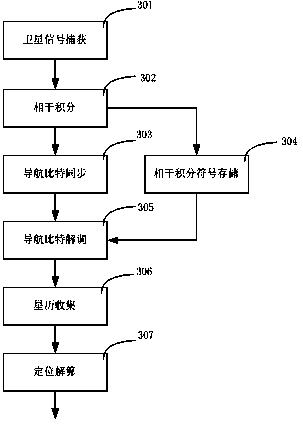
[0041] figure 1 It is a schematic diagram of the general structure of GNSS satellite signals; figure 2 It is a structural block diagram of the implementation device of the embodiment of the present invention; image 3 It is a schematic flow chart of an embodiment of the present invention.

[0042] In the embodiment of the present invention, as attached figure 2 As shown, 201 is a satellite signal acquisition unit, which completes the work of capturing visible satellites and outputs whole millisecond boundary information of the captured satellite signals. This unit can be implemented in variou...


PUM


Abstract

The invention provides a method for shortening Time To First Fix (TTFF) of a GNSS receiver. The method comprises the following steps: a satellite signal is captured and overall millisecond boundary information of the satellite signal is acquired; coherent integration is carried out on data within adjacent overall millisecond boundaries to obtain a coherent integration value; navigation bit boundaries are determined according to the coherent integration value, and simultaneously the coherent integration symbol is stored; after the bit boundaries are determined, navigation bit conciliation is carried out to obtain the final bit symbol; and satellite ephemeris is collected and positioning computing is finished. By the adoption of the technical scheme, on the basis of relatively low resource consumption and no additional construction cost, the TTFF of the GNSS receiver is effectively shortened, and positioning efficiency of the receiver is raised.

Description

technical field [0001] The invention relates to the technical field of satellite navigation signal processing, in particular to a method and system for shortening the first positioning time of a GNSS receiving device. Background technique [0002] GNSS (Global Navigation Satellite System, GNSS) uses navigation satellites for timing, positioning and ranging, and can provide all-weather, all-round and continuous real-time high-precision three-dimensional space for sea, land and air users around the world. , speed and time information. At present, GNSS includes GPS of the United States, GLONASS of Russia, Galileo system of the European Union, and Beidou navigation system of China. Taking the GPS system as an example, the system is mainly composed of three parts, namely the space part, the ground control part and the user device part. The space part is composed of 24 satellites, which are distributed in 6 track planes. The ground control part is composed of the main control st...

Claims


Application Information

Patent Timeline
IPC IPC(8): G01S19/24G01S19/27
Inventor 毛磊
Owner TECHTOTOP MICROELECTRONICS
Why Eureka
Try Eureka