
Geological data information cluster mechanism and interface aggregation model

A technology of interface aggregation and clustering, which is applied in the fields of electrical digital data processing, special data processing applications, instruments, etc., can solve problems such as poor service channels for geological data information, restricting the potential value of geological data information, and not widening the field. Social influence and public service capacity, reducing social investment waste and increasing value-added effects

Inactive Publication Date: 2013-12-25
XIAN CENT OF GEOLOGICAL SURVEY CGS
View PDF5 Cites 6 Cited by
  • Summary
  • Abstract
  • Description
  • Claims
  • Application Information

AI Technical Summary

Problems solved by technology

[0002] For a long time, a large amount of geological data formed by geological work has provided important support for social development and national economic construction, and played a particularly significant guiding role in the exploration and development of mineral resources and earth science research. As a result, many disadvantages such as poor geological data information service channels, weak capabilities, and limited fields are becoming increasingly prominent, which restricts the full play of the potential value of geological data information. Therefore, a cluster sharing service platform is constructed under a unified standard system to realize geological data Diversification of information service channels and service methods is very important

Method used


Image

  • Geological data information cluster mechanism and interface aggregation model
  • Geological data information cluster mechanism and interface aggregation model
  • Geological data information cluster mechanism and interface aggregation model

Examples


Embodiment 1

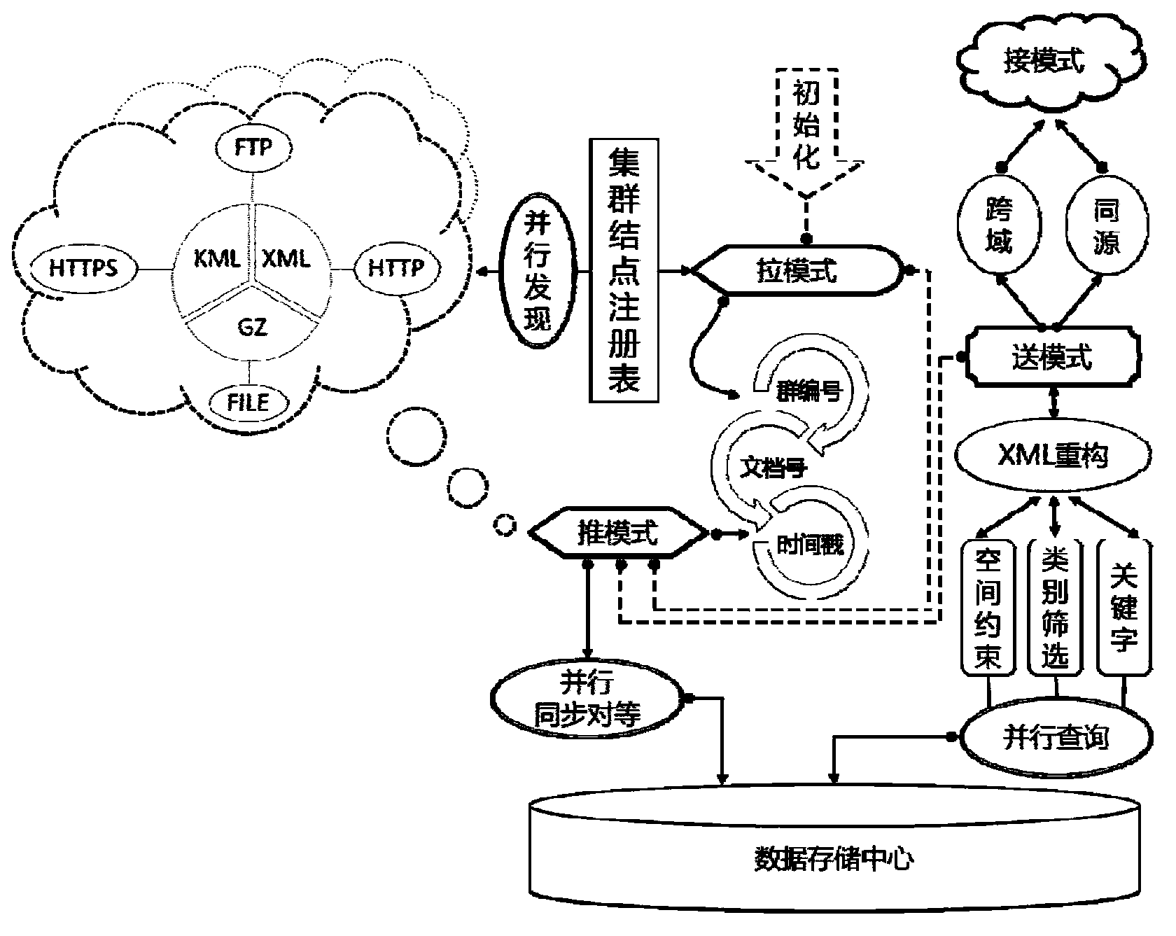
[0028] Such as figure 1 The "push-pull transfer" class system inheritance and coupling relationship diagram of the geological data information cluster mechanism and interface aggregation model of the present invention is shown, and the present invention is divided into four modes of "push-pull transfer" around the cluster mechanism and interface aggregation model as follows:

[0029] 1. Pull mode

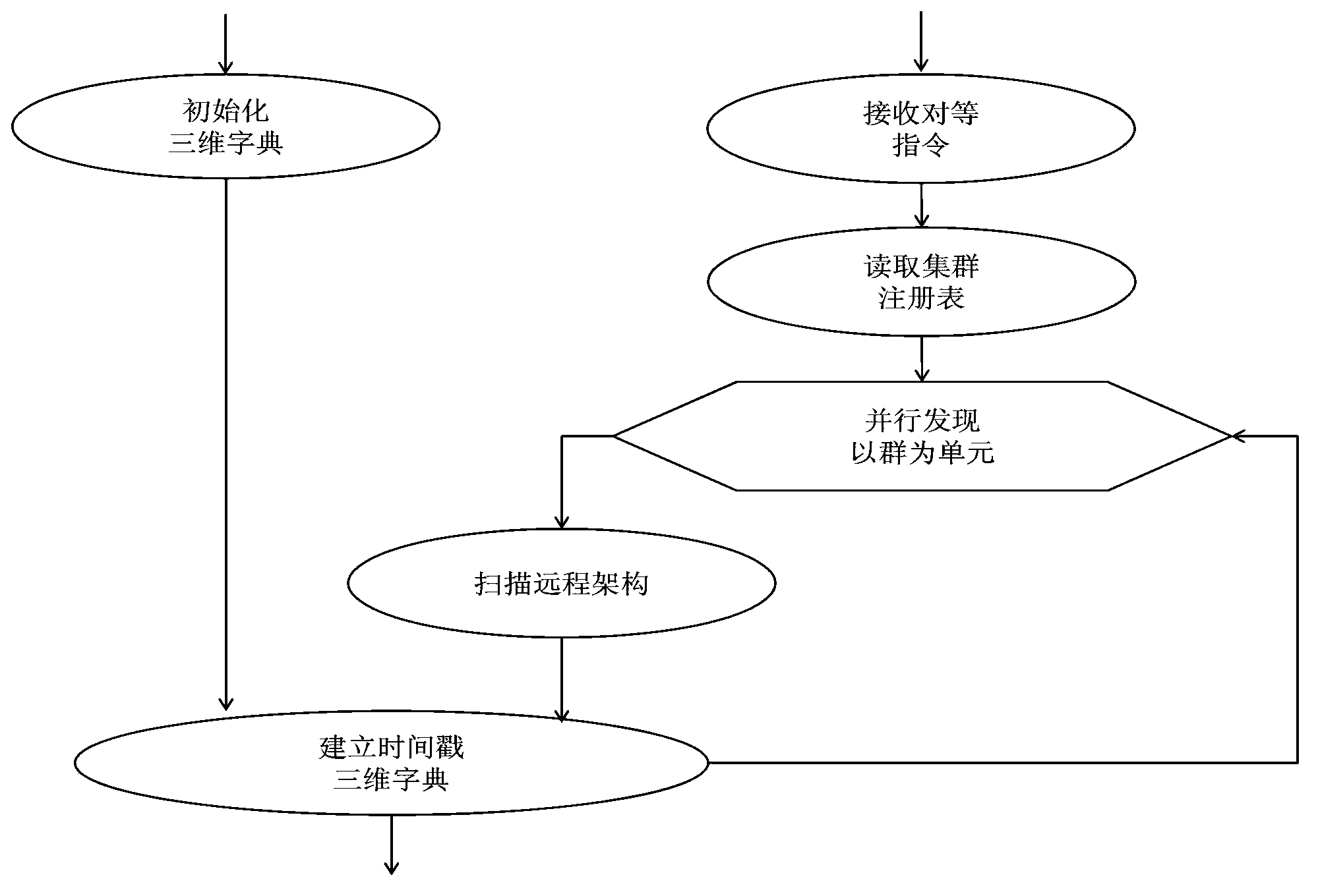
[0030] According to the cluster registry, with the group as the processing unit, CPU multi-core parallel technology is adopted for multi-protocols (such as http, https, ftp, file, etc.) for touch discovery and information capture. A three-dimensional dictionary is established by combining hash key values ​​composed of archive timestamps to form a distributed cluster networking form or architectural mapping tree. Among them, the file protocol forcibly points to the protected path of .\App Data\xmlpublish in order to support the publishing pool (private land).

[0031] The point of ...

Embodiment 2

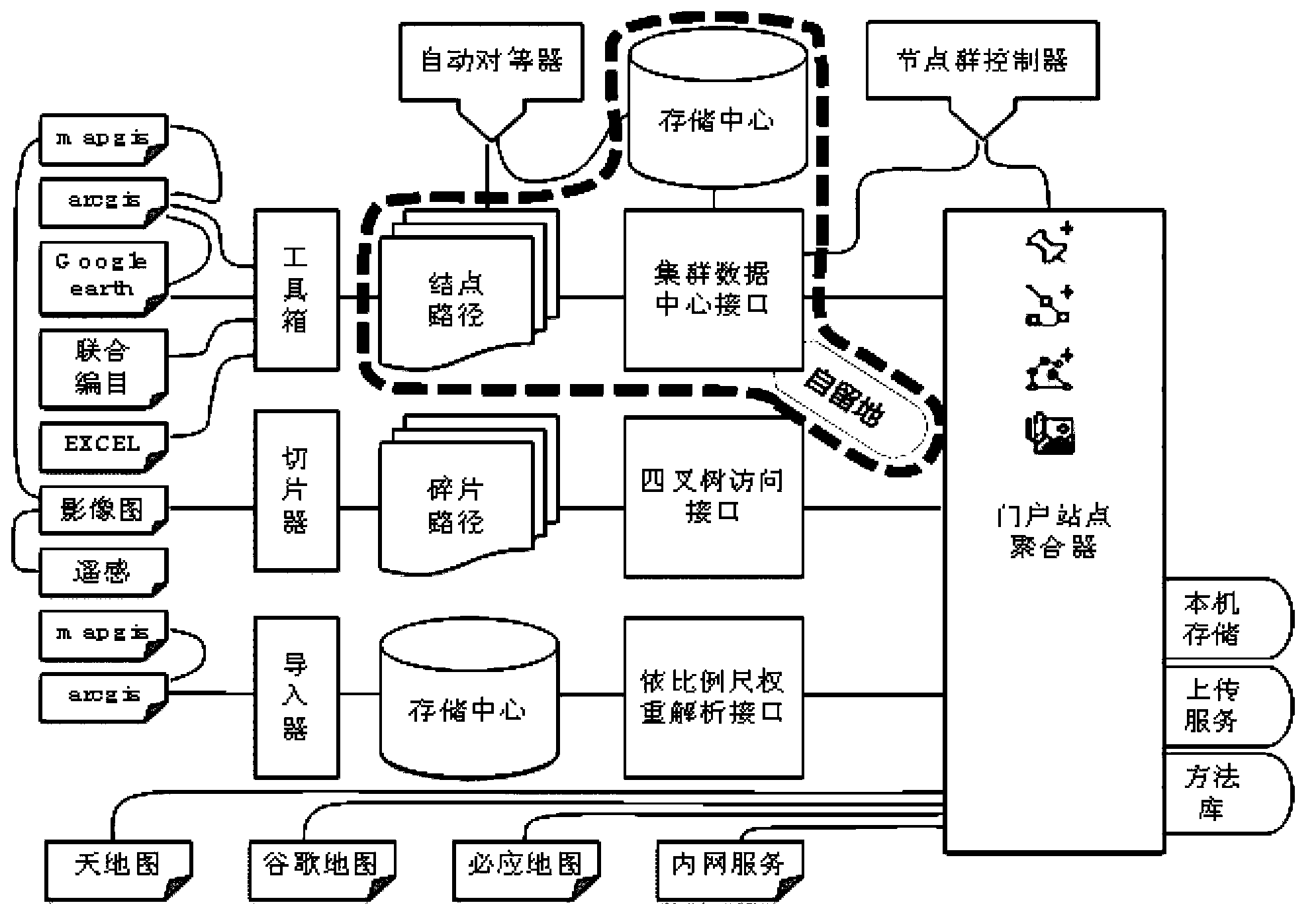
[0049] The present invention adopts the framework idea of ​​facing user groups, facing data resources, and facing collaborative services. On the basis of referring to the OGC international open standard, it uniformly describes the multivariate heterogeneous geological data information with spatial positioning characteristics, making it easy to integrate, Sharing and publishing; relying on efficient parallel computing cutting-edge theory, the node networking model is mapped into a network or tree-like "group" system with loosely coupled (elastic) characteristics, and each independent group or derived group is controlled by a "push-pull" "Transfer" interface aggregator constitutes to present the browsers access situation to the node group (Browser vs Nodes) to the outside world. The workflow is divided into four main stages in chronological order: format formulation, model design, test evaluation, and deployment and operation. The breakdown is as follows:

[0050] 1. Formulatio...


PUM


Abstract

The invention discloses a geological data information cluster mechanism and interface aggregation model, which comprises four modes of a pull mode, a push mode, a pickup mode and a sending mode, wherein the pull mode is characterized in that cluster node registry information is collected to establish a three-dimensional dictionary, and a cluster networking form or a cluster framework mapping tree is established; the push mode is characterized in that a remote path in which a certain cluster is arranged is positioned according to the cluster framework mapping tree, parallel query is carried out, whether the document flow of the remote path can be obtained or not is judged by a query result, and the document flow of the remote path is stored in a data storage center if so; the sending mode is characterized in that a request is invoked by an interface instruction, SQL (structured query language) query operation is executed to data stored in the data storage center, and a query result is sent to an invoking interface; the pickup mode is characterized in that a request is sent to the remote path interface service on a browser side. According to the geological data information cluster mechanism and interface aggregation model disclosed by the invention, an information isolated island is eliminated, and node group interconnection and interworking can be realized, thereby being favorable for avoiding the repeated input of geological work and reducing cost.

Description

technical field [0001] The invention relates to the technical field of geological survey, in particular to a "push-pull pick-up" integrated interface mechanism and aggregation model of geological data information clusters with spatial positions. Background technique [0002] For a long time, a large amount of geological data formed by geological work has provided important support for social development and national economic construction, and played a particularly significant guiding role in the exploration and development of mineral resources and earth science research. As a result, many disadvantages such as poor geological data information service channels, weak capabilities, and limited fields are becoming increasingly prominent, which restricts the full play of the potential value of geological data information. Therefore, a cluster sharing service platform is constructed under a unified standard system to realize geological data Diversification of information service c...

Claims


Application Information

Patent Timeline
Patent Type & Authority Applications(China)
IPC IPC(8): G06F17/30
Inventor 王占昌颜世强丁克永
Owner XIAN CENT OF GEOLOGICAL SURVEY CGS
Learn More