
Linear element spatial index construction method and system and retrieval method and system thereof

A spatial index and construction method technology, applied in the field of spatial information systems, to achieve the effects of reducing invalid operations, improving accuracy, and reducing data

Active Publication Date: 2013-12-25
北京恒达时讯科技股份有限公司
View PDF3 Cites 10 Cited by
  • Summary
  • Abstract
  • Description
  • Claims
  • Application Information

AI Technical Summary

Problems solved by technology

[0005] The technical problem to be solved by the present invention is: how to provide a linear element spatial index construction method, system and its retrieval method and system, so as to reduce the low accuracy of the query results caused by the excessively large area of ​​the circumscribed rectangle of the query in the prior art. technical problem

Method used


Image

  • Linear element spatial index construction method and system and retrieval method and system thereof
  • Linear element spatial index construction method and system and retrieval method and system thereof
  • Linear element spatial index construction method and system and retrieval method and system thereof

Examples


Embodiment Construction

[0051] The specific implementation manners of the present invention will be further described in detail below in conjunction with the accompanying drawings and embodiments. The following examples are only used to illustrate the present invention, but not to limit the scope of the present invention.

[0052] R-tree is an efficient spatial index, but because the basis of indexing is the circumscribed polygon of the geometric object, it is suitable to use area elements.

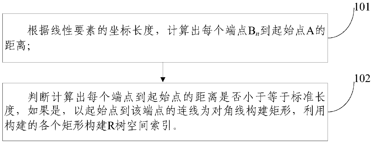
[0053] For the long-length linear element spatial index, the embodiment of the present invention first proposes an R-tree-based linear element spatial index construction method, such as figure 1 As shown, the method includes:

[0054] Step 100: Calculate each end point B according to the coordinate length of the linear element n The distance to the starting point A, the coordinates of the starting point A is (x 0 ,y 0 ), endpoint (x n+1 ,y n1 );

[0055] Calculate according to the following formula:

[0...


PUM


Abstract

The invention discloses a linear element spatial index construction method and system and a retrieval method and a system thereof, relating to the technical field of spatial information systems. The building method comprises the following steps: calculating the distance between each end point Bn and an initial point A according to the coordinate length of a linear element; judging whether the calculated distance between each end point and the initial point is less than or equal to a standard length or not; if so, constructing a rectangle by taking a connection line from the initial point to the end point as a diagonal; and constructing an R tree spatial index by using each constructed rectangle. The invention further discloses a linear element spatial index construction system based on an R tree, a retrieval method and a retrieval system thereof. According to the technical scheme disclosed by the invention, specific to long linear elements, the area of an external rectangle is reduced, the data volume of returned data and invalid operation are reduced, and the query efficiency and accuracy are increased.

Description

technical field [0001] The present invention relates to the technical field of spatial information systems, in particular to a linear element spatial index construction method, system and retrieval method and system. Background technique [0002] The R-tree is a height-balanced tree, which is a natural extension of the B-tree in the k-dimension. The MBR of the spatial object is used to approximate the expression of the spatial object. The R-tree is established according to the MBR of the ground object, and the spatial object occupying a certain range in the space can be directly calculated. to index. Each node of the R tree corresponds to disk page D and area I. If the node is not a leaf node, the areas of all child nodes of the node are within the range of area I and stored in the disk page D. If the node is a leaf node, then what is stored in the disk page D will be a series of sub-areas within the range of area I, and the sub-areas tightly surround the spatial object, g...

Claims


Application Information

Patent Timeline
Patent Type & Authority Applications(China)
IPC IPC(8): G06F17/30
Inventor 蔡越王翔王玫
Owner 北京恒达时讯科技股份有限公司
Learn More