Public space positioning and navigation method and system based on two-dimension code and intelligent terminal

An intelligent terminal and spatial positioning technology, applied in the physical field, can solve problems such as unsatisfactory large-scale indoor space navigation technology, and achieve good economic and social benefits, convenient use, and good feasibility.

Inactive Publication Date: 2014-01-01
SHANGHAI POSTS & TELECOMM DESIGNING CONSULTING INST
View PDF9 Cites 31 Cited by
  • Summary
  • Abstract
  • Description
  • Claims
  • Application Information

AI Technical Summary

Problems solved by technology

[0006] The purpose of the present invention is to provide a public space positioning and navigation method based on two-dimensional codes and intelligent terminals. Technical issues with suboptimal navigation technology

Method used


Image

  • Public space positioning and navigation method and system based on two-dimension code and intelligent terminal

Examples


Embodiment 1

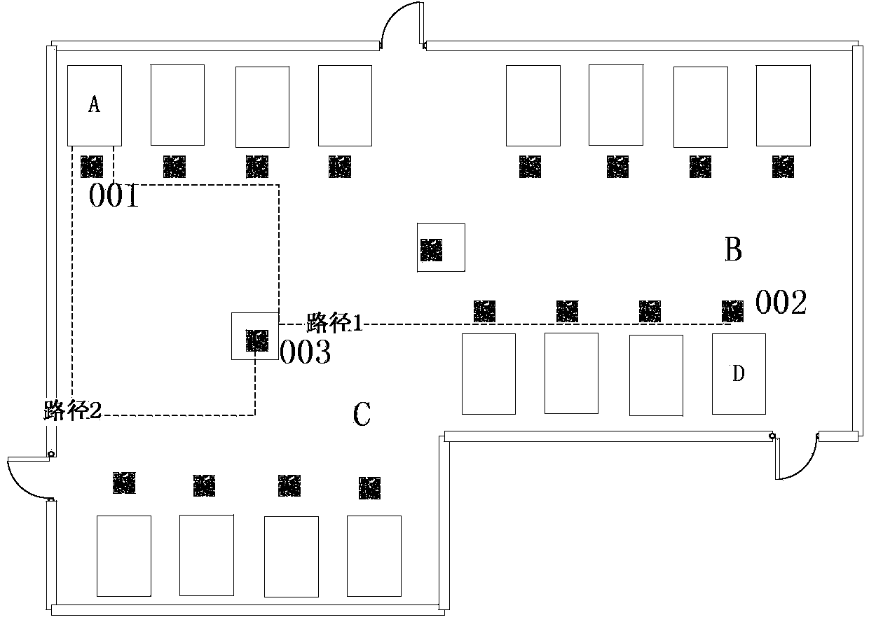
[0022] Such as figure 1 As shown, in an embodiment that realizes car search in a parking lot,

[0023] First make a map of the parking lot space, including parking spaces, pillars, walls, doors and other fixed objects;

[0024] Two-dimensional code signs are pasted on different positions in the space (in front of the parking space, on the pillars), and the two-dimensional code position numbers (001, 002, 003...) are set on the corresponding positions on the map. One-to-one correspondence between code position numbers;

[0025] The user installs the spatial map software containing the location number of the QR code (001, 002, 003...) on the smart terminal;

[0026] After parking the car in the parking space A, the user scans the two-dimensional code logo on the location A through the space map software installed on the smart terminal, so that the two-dimensional code position number corresponding to the two-dimensional code logo on the space map software will be one-to-one. ...


PUM


Abstract

The invention relates to a public space positioning and navigation method based on a two-dimension code and an intelligent terminal. The public space positioning and navigation method comprises the following steps of firstly making a map of a public space; respectively arranging two-dimension code identifiers in the public space; arranging two-dimension code position numbers at the corresponding positions of the map; installing the map in the intelligent terminal; scanning the two-dimension code identifier closest to one position in the public space as a destination by virtue of the intelligent terminal, and saving the two-dimension code identifier in the intelligent terminal; after moving to another position, scanning the two-dimension code identifier closest to the current position as a starting point; and counting to obtain a navigation route from the starting point to the destination, and displaying the navigation route. According to the public space positioning and navigation method, the positioning and navigation of the public space are realized by virtue of the two-dimension code and the intelligent terminal, and a user can be assisted to carry out quick positioning, navigation, vehicle searching and the like in a complex public space range; meanwhile, the public space positioning and navigation method is convenient for the user to use, has the characteristics of convenience in use and maintain, simplicity and easiness in implementation and good feasibility and can bring good economic and social benefits.

Description

Technical field: [0001] The present invention relates to the field of physics, in particular to positioning and navigation technology, in particular to a public space positioning and navigation method and system based on a two-dimensional code and an intelligent terminal. Background technique: [0002] In the prior art, people often get lost in large public spaces, for example, they cannot find the store they want to go to in a large shopping mall; [0003] Chinese patent CN102840864A introduces a method and device for positioning and navigation through two-dimensional codes. By deploying two-dimensional codes at bus stops, the two-dimensional codes correspond to information such as bus stops and bus lines, thereby helping users calculate transfer navigation through the system routes and rides. However, this invention is not based on path navigation between any two actual locations, and has relatively large limitations. [0004] Chinese patent CN103165025A introduces a two...

Claims


Application Information

Patent Timeline
Patent Type & Authority Applications(China)
IPC IPC(8): G01C21/34
CPCG01C21/34G01C21/3623
Inventor 黄军政胡建忠朱文琦吴震亚杨海燕王永利钱虹王润垠
Owner SHANGHAI POSTS & TELECOMM DESIGNING CONSULTING INST
Why Eureka
Try Eureka