Method for determining side slope critical drainage water line on basis of monitoring

A water level line and slope technology, applied in the satellite radio beacon positioning system, displaying liquid level indicators, measuring devices and other directions through pressure measurement, can solve the problem of difficult to obtain physical and mechanical parameters of rock and soil, and difficult to truly reflect landslide slopes The actual situation, the cumbersome calculation process and other problems

Inactive Publication Date: 2014-01-15
QINGDAO TECHNOLOGICAL UNIVERSITY +1
View PDF5 Cites 15 Cited by
  • Summary
  • Abstract
  • Description
  • Claims
  • Application Information

AI Technical Summary

Problems solved by technology

The determination of the critical groundwater level by such methods is based on the determination of reasonable constitutive relations and accurate physical and mechanical parameters of the soil layer, but it is difficult to obtain accurate physical and mechanical parameters of rock and soil due to the limitations of sampling and test conditions. It is difficult to truly reflect the actual situation of the landslide slope, and the results are prone to large errors due to the above factors, the "black box" of the finite element software and human factors, and there are also limitations such as cumbersome calculation process, large calculation amount and long calculation time sexual problems

Method used


Image

  • Method for determining side slope critical drainage water line on basis of monitoring
  • Method for determining side slope critical drainage water line on basis of monitoring
  • Method for determining side slope critical drainage water line on basis of monitoring

Examples


Embodiment Construction

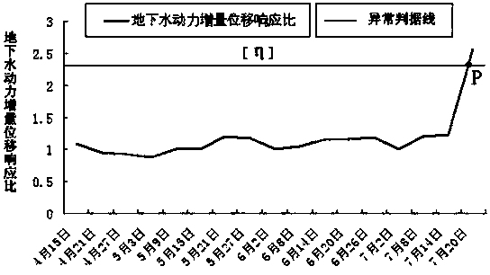
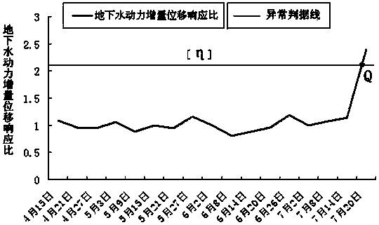
[0043] In order to better illustrate the present invention, a landslide is taken as an example for detailed description below. The landslide is a landslide of accumulative layers along the Yangtze River. The monitoring period of this landslide is from mid-April to the end of July. During this period, the groundwater level rises and is in the loading stage. After that, the groundwater level drops and unloading occurs, which is not considered. Its main steps are as follows:

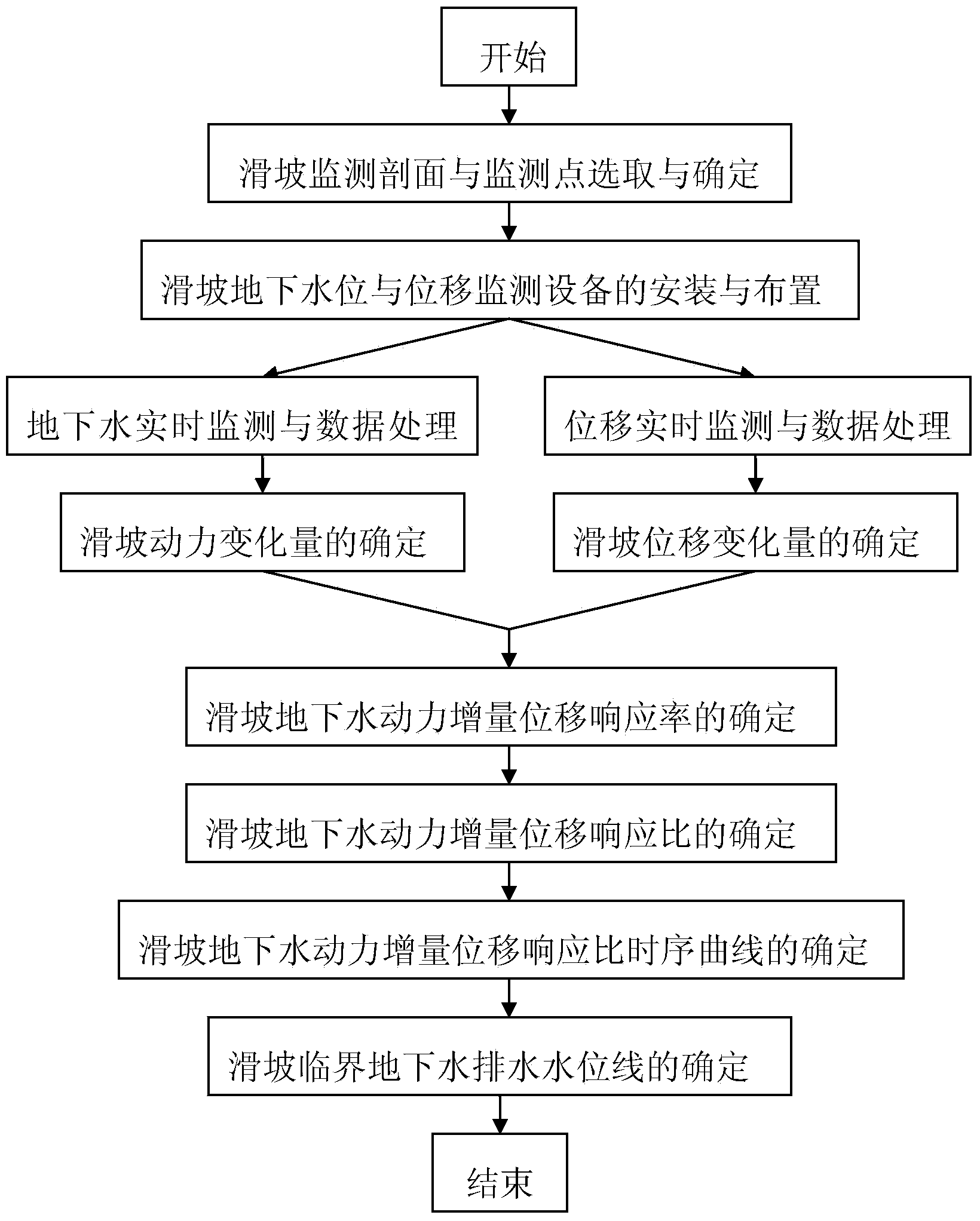
[0044] Step 1: Selection and determination of landslide monitoring profile and monitoring points

[0045] The landslide permanent groundwater distribution area and the significant deformation area are selected as the landslide monitoring area, and the main monitoring section and two monitoring points of the slope, namely A and B, are determined according to the law of groundwater and displacement changes. Groundwater level and displacement monitoring holes 3 are arranged at two monitoring points on the mai...


PUM


Abstract

The invention relates to a treatment method for determining the position of a landslide drainage water line simultaneously on the basis of the underground water level and displacement monitoring data and coupling analysis. The method for determining the side slope critical drainage water line on the basis of monitoring comprises a first step of landslide monitoring section and monitoring point selection and determination, a second step of installation and arrangement of landslide underground water level and displacement monitoring devices, a third step of real-time monitoring and treatment of the underground water level and displacement, a fourth step of determination of the landslide underground water dynamic increment displacement response rate, a fifth step of determination of a landslide underground water dynamic increment displacement response ratio and a time sequence curve of the landslide underground water dynamic increment displacement response ratio and a sixth step of determination of the landslide critical underground water drainage water line. The landslide drainage water line is obtained by utilizing underground water dynamic increment displacement response ratio parameters so as to treat landslide with underground water serving as a leading trigger factor, the relations between the real landslide water line and a landslide stability state can be reflected visually, and effectiveness and practicality of the method are embodied.

Description

technical field [0001] The invention relates to a treatment method for determining the position of a landslide drainage water level based on groundwater level and displacement monitoring data and coupled analysis, in particular to a method for determining and controlling the critical water level of groundwater drainage under the condition of ensuring the stability of the landslide. Background technique [0002] As one of the most destructive and dangerous geological disasters, landslides are the key to disaster reduction and prevention in a timely and effective manner. Among them, selecting and determining feasible and effective prevention and control programs and measures is the primary task in the process of landslide control. Water-induced landslides account for a large proportion of landslide disasters, and they are very sudden and destructive. Therefore, how to scientifically and effectively prevent and control such landslides has extremely important significance and va...

Claims


Application Information

Patent Timeline
Patent Type & Authority Applications(China)
IPC IPC(8): G01F23/14G01B21/32G01S19/14G08C17/02
Inventor 贺可强刘晓红崔宪丽张娟王海艇
Owner QINGDAO TECHNOLOGICAL UNIVERSITY
Why Eureka
Try Eureka