Method for line laying operation guided through image

An image and image display technology, which is applied in the field of image-guided pay-off, can solve the problems of low precision and low work efficiency.

Inactive Publication Date: 2014-02-19
罗建刚
View PDF2 Cites 7 Cited by
  • Summary
  • Abstract
  • Description
  • Claims
  • Application Information

AI Technical Summary

Problems solved by technology

Existing method of laying out wires, useful theodolite or total station to carry out fixed direction, fixed distance wire method, and the wire method of using GPS or other satellite positioning facilities to carry out, its common defect is that the release of single plane coordinate data At the beginning of the work, since the theodolite has not been used to measure and guide, or the theodolite has not been used to guide a direction and a far distance after measurement, the front-view personnel generally cannot clearly know where the plane coordinate data corresponds to the real point. It takes more t

Method used


Image

  • Method for line laying operation guided through image
  • Method for line laying operation guided through image
  • Method for line laying operation guided through image

Examples


Embodiment Construction

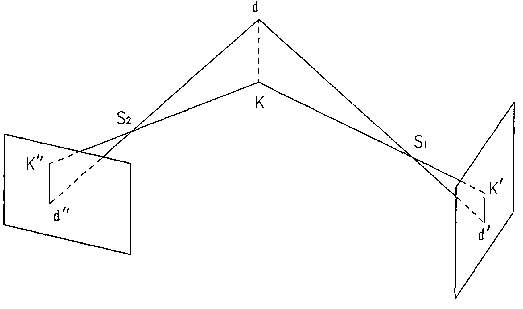
[0007] figure 1 Among them, this figure is a schematic diagram not to scale. In order to make the view clear, the photosensitive surface and the main distance of the image are enlarged. Space real point, d is the highest hypothetical space real point, k is the lowest hypothetical space real point, when these two space real points are preset, their elevation estimates are reasonable, so that the benchmark can be placed on the surface of the plane coordinate data corresponding to the real point Can be coincident with the connection of d and k (if there is coincidence, it can be coincidence or partial coincidence), d and k are in S 1 , S 2 The images on the image plane captured by the two photographic devices in the photography center are respectively d', k' and d", k", and the line segment connecting d', k', d', k' is the plane coordinate data in S 1 It is the pile line on the image plane of the photography center, connecting d", k", and the line segment between d", k" is the...


PUM


Abstract

The invention discloses a method for line laying operation guided through an image. According to the method, a hypothetic elevation, a hypothetic spatial point, an azimuth angle and a vertical angle are adopted to reckon the theoretical imaging position of a spatial real point in an image. Through the method, a theoretical real plumb line or part of the plumb line (namely pile line or independent image point) of to-be-laid plane coordinate data is plotted in an image shot for a area for allowing a line to be laid; foresight staff hold a surveying rod to a line laying site and erect the surveying rod at a site position where the central axes of the shadow of the surveying rod in the images shot by multiple photographic devices overlaps with the independent image points in the images where the shadow of surveying rod is positioned, or overlaps with pile lines of the images where the shadow of the surveying rod is positioned, and the site position is the accurate position of the laid line on the spot.

Description

Technical field [0001] The invention relates to an image-guided setting out method, which belongs to the field of surveying and mapping, and relates to photographic surveying and mapping and surveying and mapping setting out (that is, releasing theoretical plane coordinate data to the field, both setting out and setting out points are the same meaning). Background technique [0002] Have not yet consulted the existing background technical materials of the method for setting out the wire with image guidance. Existing method of laying out wires, useful theodolite or total station to carry out fixed direction, fixed distance wire method, and the wire method of using GPS or other satellite positioning facilities to carry out, its common defect is that the release of single plane coordinate data At the beginning of the work, since the theodolite has not been used to measure and guide, or the theodolite has not been used to guide a direction and a far distance after measurement, t...

Claims


Application Information

Patent Timeline
IPC IPC(8): G01C15/00
CPCG01C15/00G01C11/08
Inventor 罗建刚
Owner 罗建刚
Why Eureka
Try Eureka