Method for showing real live-action space by navigation map

A navigation map and real technology, applied in the field of navigation, can solve problems such as excessive amount of raw data, and achieve the effect of improving efficiency, improving performance and improving utilization rate

Active Publication Date: 2014-02-19
SHENYANG MXNAVI CO LTD
View PDF3 Cites 4 Cited by
  • Summary
  • Abstract
  • Description
  • Claims
  • Application Information

AI Technical Summary

Problems solved by technology

[0006] The present invention provides a method for displaying a real scene space on a navigation map, which is characterized in that: in the method for displaying a real scene space on a navigation map, the data storage and processing method is as follows, and the data part is input from the outside, in order to solve the original The problem of excessive data volume requires data compression after data entry. The basic idea of ​​the solution proposed here is to reorganize and sort the original data, and it is necessary to ensure that the data is not damaged

Method used


Image

  • Method for showing real live-action space by navigation map
  • Method for showing real live-action space by navigation map
  • Method for showing real live-action space by navigation map

Examples


Embodiment 1

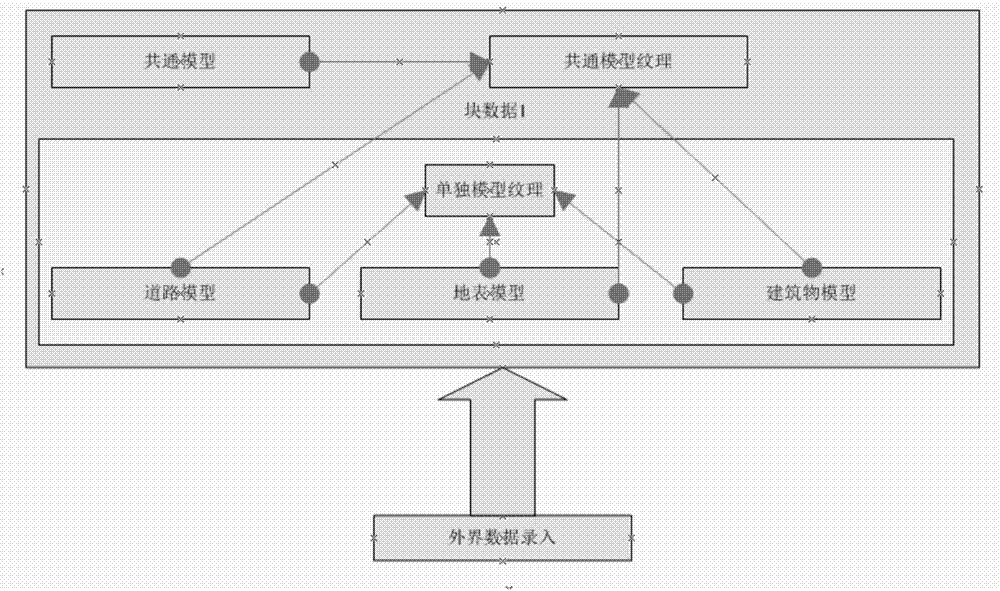
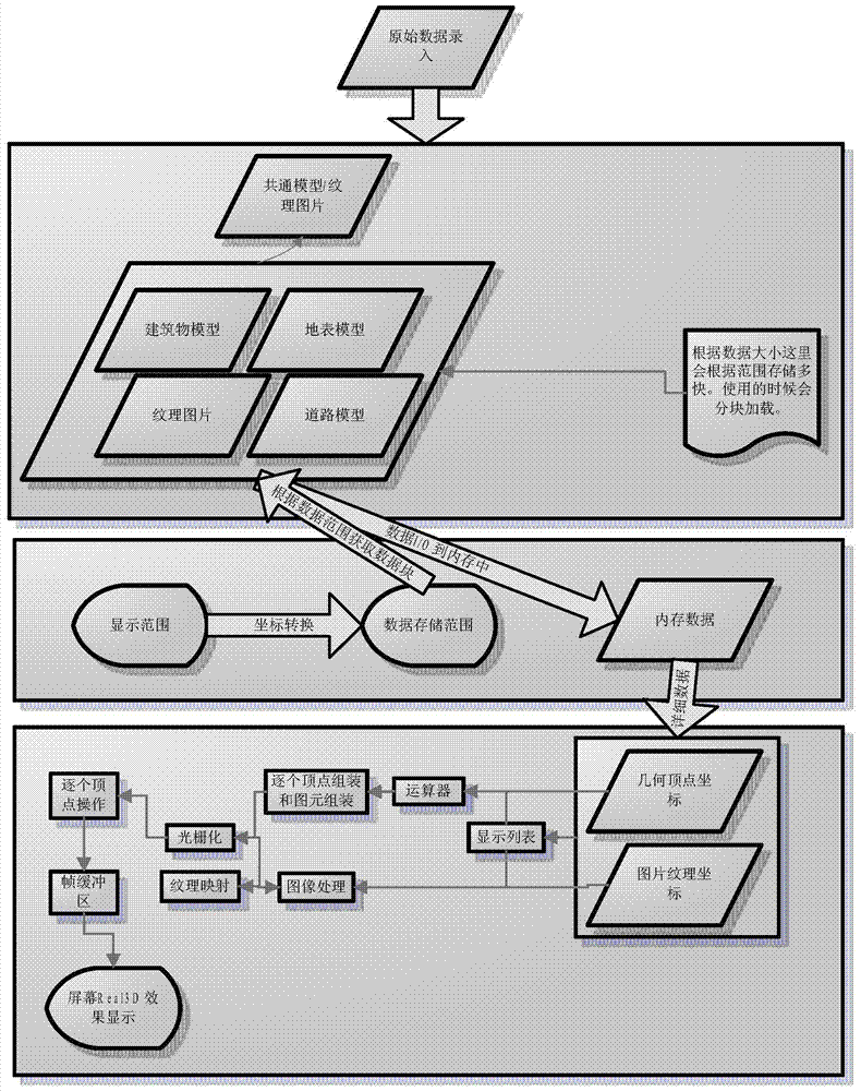
[0020] This embodiment provides a method for a navigation map to display a real real-world space, characterized in that: the method for the navigation map to display a real real-world space, the data storage and processing method is as follows, the data part is entered from the outside, in order to solve The problem of excessive amount of original data requires data compression after data entry. The basic idea of ​​the solution proposed here is to reorganize and sort the original data and ensure that the data is not damaged. Data mainly consists of two parts: object model and model texture;

[0021] The object model is divided into two parts, one part is a separate model that has no commonality, such as road model, ground model, and building model. One part is a common model with commonality, such as street lights, guardrails, etc. In the data storage process, the common model is proposed as one copy, and the individual models continue to maintain independence, so that the repea...


PUM


Abstract

The invention relates to a method for showing real live-action space by a navigation map. A storing and processing mode of data is that: a part of the data is inputted from the external part, the data needs to be compressed after being inputted in order to solve a problem that the amount of original data is too large. Basic ideas of the solution provided by the invention are that: the original data is organized and ranked again, and the data is ensured not to be damaged; the data is mainly composed of two parts which are object models and model textures, wherein the object models are divided into two parts, one part is single models having no commonality, and the other part is common models having the commonality; original vertex coordinates and texture coordinates are stored by floating-point numbers. The method provided by the invention has the advantages that a problem that the storage medium capacity is restricted is solved through compression of the data, and the utilization rate of the storage medium is improved. The method improves the efficiency of data reading of programs, has an especially obvious effect on guidance and prompts for a complex intersection, and is an essential live-action display technology for navigation in metropolis in the future.

Description

technical field [0001] The invention relates to the field of navigation, in particular to a method for displaying a real real scene space on a navigation map. Background technique [0002] With the rise of the automotive electronics industry, car navigation systems have begun to come into people's sight. Car navigation system is a complex that provides drivers with services such as electronic maps, vehicle positioning, real-time voice guidance, and real-time screen guidance based on embedded hardware, global GPS positioning, and geographic information data. Although automotive electronic navigation products have been developed for decades, all areas of navigation have made unprecedented progress, such as the improvement of GPS accuracy, the rise of voice navigation, the application of positioning and locking technology, the application of dual-page technology, etc. , but in terms of map display, it is still limited to the basic drawing of points, lines, and planes, which is...

Claims


Application Information

Patent Timeline
Patent Type & Authority Applications(China)
IPC IPC(8): G06T17/05
Inventor 郭瑞瑞王海世赖克朱小莹
Owner SHENYANG MXNAVI CO LTD
Why Eureka
Try Eureka