Graded slope SCS+C model mountainous topographic correction method
A terrain correction and slope grade technology, applied in image data processing, instruments, calculations, etc., to achieve the effects of simple terrain correction, improved work efficiency, and convenient operation
- Summary
- Abstract
- Description
- Claims
- Application Information
AI Technical Summary
Problems solved by technology
Method used
Image
Examples
specific Embodiment approach
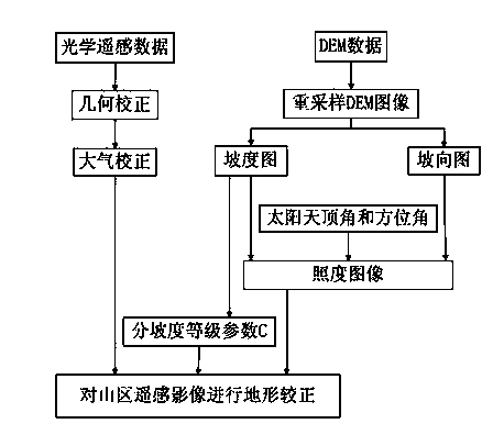
[0018] The sub-slope level SCS+C terrain correction is composed of the sub-slope level coefficient C and the SCS model, where the sub-slope level coefficient C is 1-5, 5-10, 10-15, 15-20, 20-25, 25-30, 30-35, 35-40, 40-45, 45- the maximum slope, one grade every 5 degrees (except 0-1 degree), the sub-slope grade coefficient C is calculated with the SCS model, and the sub-slope grade coefficient C is divided into The section calculates the relationship between the coefficient C and the SCS model. Sub-slope grade coefficient C and SCS model compose sub-slope grade SCS+C terrain correction. The specific implementation is as follows:
[0019] In the topographic correction of remote sensing images in mountainous areas with complex terrain conditions, there is a steep or gentle slope in the remote sensing image processing area that cannot be followed by a standard, as shown in the figure: First, according to the solar zenith angle and solar azimuth angle of the remote sensing image ...
PUM
 Abstract
Description
Claims
Application Information
 - R&D
- Intellectual Property
- Life Sciences
- Materials
- Tech Scout
- Unparalleled Data Quality
- Higher Quality Content
- 60% Fewer Hallucinations
Browse by: Latest US Patents, China's latest patents, Technical Efficacy Thesaurus, Application Domain, Technology Topic, Popular Technical Reports.
© 2025 PatSnap. All rights reserved.Legal|Privacy policy|Modern Slavery Act Transparency Statement|Sitemap|About US| Contact US: help@patsnap.com

