Method for analyzing influences of background ionosphere on GEO SAR imaging

A background ionosphere and analysis method technology, applied in the field of geosynchronous orbit synthetic aperture radar ionosphere effect analysis, can solve the problem that the ionosphere cannot be ignored, and achieve the effect of improving the accuracy of analysis and accurate modeling

Active Publication Date: 2014-03-26
BEIJING INSTITUTE OF TECHNOLOGYGY
View PDF3 Cites 19 Cited by
  • Summary
  • Abstract
  • Description
  • Claims
  • Application Information

AI Technical Summary

Problems solved by technology

Compared with traditional low-orbit SAR, since the aperture time of GEO SAR is as long as a thousand seconds (low-orbit SAR is only about one second), the change of the ionosphere during the aperture time will become non-negligible, and the freezing in traditional low-orbit SAR Model assumptions will be invalid, and the impact of ionosphere changes on GEO SAR imaging must be considered
None of this has been covered in existing GEO SAR studies

Method used


Image

  • Method for analyzing influences of background ionosphere on GEO SAR imaging
  • Method for analyzing influences of background ionosphere on GEO SAR imaging
  • Method for analyzing influences of background ionosphere on GEO SAR imaging

Examples


Embodiment Construction

[0111] The present invention will be described in detail below with reference to the accompanying drawings and examples.

[0112] In this example, the relevant parameters are as follows:

[0113] Orbital semi-major axis: 42164.17Km, orbital inclination: 53 0 , orbit eccentricity: 0.07, argument of perigee: 270 0

[0114] Ascending node right ascension: 265 0 , Antenna size: 30m, frequency band: L band (0.24m wavelength), bandwidth: 80MHz, 120MHz, aperture time: 500 seconds, 1000 seconds, 1500 seconds.

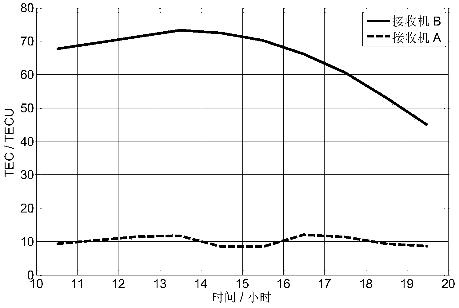
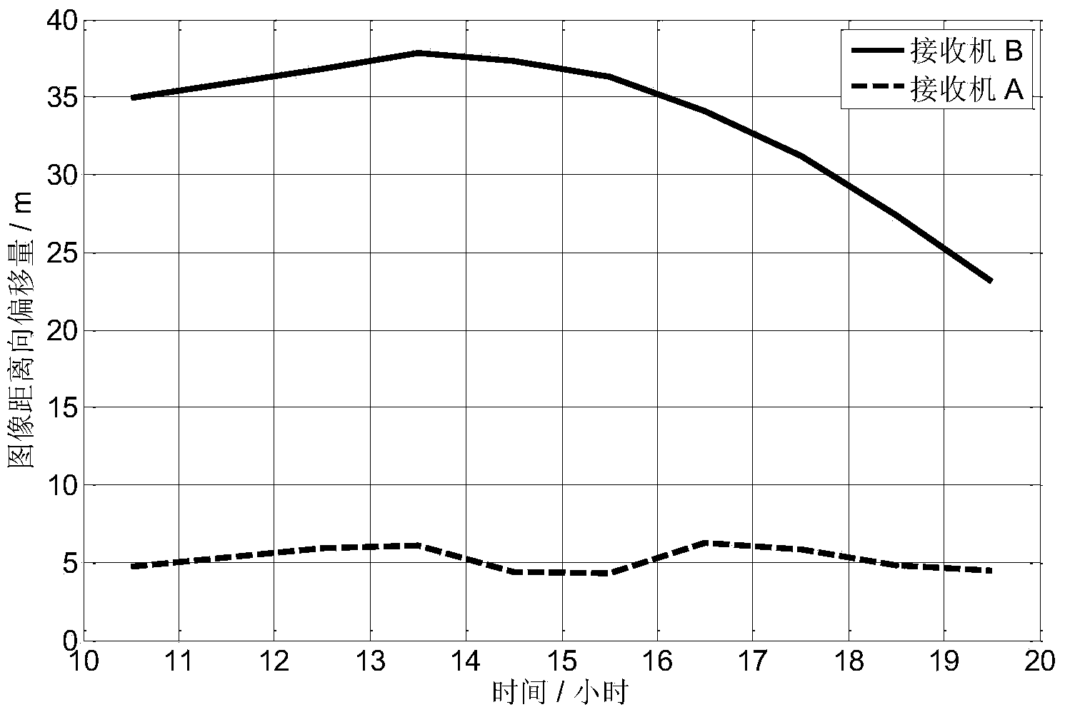
[0115] At the same time, the Klobuchar model and the Beidou navigation satellite are used to obtain ionospheric data, and two receivers are set up, which are respectively located in the mid-latitude region, and the geographical coordinates are 43°34' north latitude and 120°16' east longitude; in the equatorial region, the geographical coordinates are 3° north latitude 52', 120 E °4'. The obtained TEC data on August 29, 2013 is as follows figure 2 shown.

[0116] Adopt ...


PUM


Abstract

The invention discloses a method for analyzing influences of a background ionosphere on GEO SAR imaging. The method includes the steps that a GEO SAR echo signal model influenced by a time-varying ionosphere is established, image offset and defocusing phase which are used for analyzing influences on imaging are derived on the basis of the model, and then judgment of the influences on imaging is performed; during analysis, GEO SAR echo signals influenced by the time-varying ionosphere and the measuring data of the ionosphere total electron content TEC on the propagation paths of the GEO SAR signals are obtained, polynomial fitting is performed on the TEC measuring data three times, a constant term and coefficients of first three items are obtained, echo signal parameters and TEC coefficients are substituted into a derived expression of the image offset and the defocusing phase, and compared with a threshold value, the influences of the background ionosphere on GEO SAR imaging are obtained. According to the method, modeling is performed specifically and is accurate, and imaging analysis is performed on the basis of the accurate model so that the analysis accuracy can be improved.

Description

technical field [0001] The invention relates to an ionospheric effect analysis method of a geosynchronous orbit synthetic aperture radar, which belongs to the technical field of synthetic aperture radar. Background technique [0002] Synthetic Aperture Radar (SAR) is an all-weather, all-time high-resolution microwave remote sensing imaging radar that can be installed on aircraft, satellites, missiles and other flying platforms. Since its invention in the 1950s, it has been widely used in many fields, such as disaster control, vegetation analysis, microwave remote sensing and other fields. [0003] Geosynchronous Orbit Synthetic Aperture Radar (GEO SAR) is a SAR satellite operating on a geosynchronous elliptical orbit at a height of 36000km. Compared with low-orbit SAR (LEO SAR, the orbit height is lower than 1000Km), GEO SAR has the characteristics of large imaging range, short revisit time, and strong anti-strike and anti-destruction capabilities. It has become a research ...

Claims


Application Information

Patent Timeline
Patent Type & Authority Applications(China)
IPC IPC(8): G01S7/40
CPCG01S7/02G01S7/40G01S13/90G01S13/9058
Inventor 胡程龙腾田野曾涛李元昊
Owner BEIJING INSTITUTE OF TECHNOLOGYGY
Why Eureka
Try Eureka