
Method and system for splicing images of unmanned aircrafts in real time

An unmanned aerial vehicle and real-time image technology, applied in the field of image processing, can solve the problems of poor real-time image stitching and obvious stitching traces, and achieve excellent real-time performance, good stitching effect, and the effect of eliminating stitching lines

Active Publication Date: 2014-03-26
SPACE STAR TECH CO LTD
View PDF5 Cites 34 Cited by
  • Summary
  • Abstract
  • Description
  • Claims
  • Application Information

AI Technical Summary

Problems solved by technology

[0013] The problem solved by the technology of the present invention is: to overcome the deficiencies of the prior art, to provide a real-time image stitching method and system for an unmanned aerial vehicle, and to solve the problems of poor real-time image stitching and obvious stitching traces in the prior art

Method used


Image

  • Method and system for splicing images of unmanned aircrafts in real time
  • Method and system for splicing images of unmanned aircrafts in real time
  • Method and system for splicing images of unmanned aircrafts in real time

Examples


Embodiment Construction

[0061] The technical scheme of the present invention is described in detail below in conjunction with accompanying drawing:

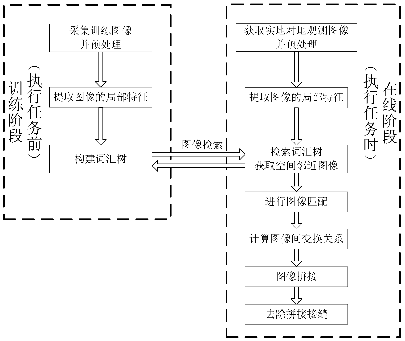
[0062] Such as figure 1 As shown, the present invention discloses a real-time image mosaic method and system of an unmanned aerial vehicle. The method includes two stages: the training stage, that is, before the unmanned aerial vehicle performs a task, the training image is collected and the local features of the training image are extracted, and a vocabulary tree is constructed. ;

[0063] training phase

[0064] Before the unmanned aerial vehicle performs the task, collect the training image and extract the local features of the training image, and construct the vocabulary tree; the process only needs to be carried out once, and the constructed vocabulary tree can be used in different tasks; it is realized by the following steps:

[0065] 1. Collect training images and preprocess them

[0066] Collect training images and extract training image inte...


PUM


Abstract

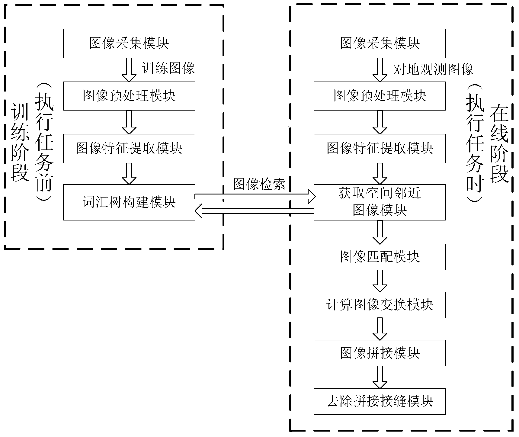
The invention discloses a method and a system for splicing images of unmanned aircrafts in real time. The method and the system mainly solve the problem of poor image splicing real-time performance or obvious splicing traces in the prior art. The method includes a training stage: acquiring training images before the unmanned aircrafts execute tasks, extracting local features of the training images and building vocabulary trees; an online stage: acquiring practical earth observation images when the unmanned aircrafts execute the tasks, extracting local features of the images, retrieving the vocabulary trees to quickly search spatially adjacent images, matching the spatially adjacent images, computing transformation relations among the images, splicing the images according to the transformation relations and removing splicing joints. The method and the system have the advantages that the images of the unmanned aircrafts can be spliced by the aid of the method and the system, and broad vision field ranges can be provided for users; the method and the system are high in real-time performance and good in splicing effect, and requirements of application places in multiple fields can be met.

Description

technical field [0001] The invention relates to a real-time image mosaic method and system of an unmanned aerial vehicle, belonging to the field of image processing. Background technique [0002] A large number of aerial remote sensing images can be obtained by the multi-modal CCD camera carried by the unmanned aerial vehicle for earth observation. When the UAV remote sensing platform acquires images, it is limited by the flying height of the UAV and the focal length of the digital camera, so it is difficult for a single image to completely contain the region of interest. In order to obtain more information of the target area, it is necessary to further expand the field of view. Images obtained from different angles can be smoothly and seamlessly spliced ​​and fused to construct a mosaic map to achieve the purpose of expanding the field of view. [0003] In the patent application document with the application number 200810237427.8 and the invention name "Image Mosaic Method...

Claims


Application Information

Patent Timeline
IPC IPC(8): G06T5/50G06T7/00
Inventor 安山王婷张宏张春泽
Owner SPACE STAR TECH CO LTD
Learn More